Property Record
Mem Pkwy S, Huntsville, AL 35803
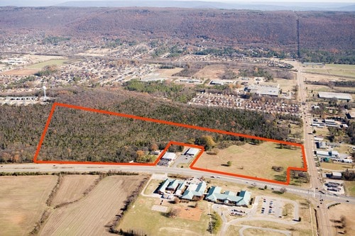
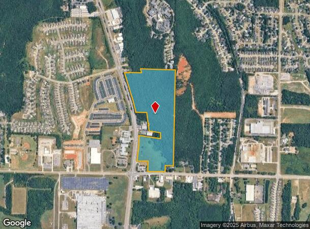
This Property Is For Sale
NEARBY LISTINGS FOR SALE OR LEASE
Property Detail
Mem Pkwy S
Huntsville, AL
Amsouth Subdivision
23-04-18-0-001-022.000
LOT 1 AMSOUTH SUBDIVISION PB # 20050616000390350
Pasture
Madison
X
Alabama
01089C0456G
1
2025
19.14 AC
2025
South Madison County
002924
Huntsville
DEMOGRAPHICS near Mem Pkwy S
1 Mile
3 Mile
5 Mile
2024 Total Population
5,616
27,909
54,769
2029 Population
6,634
32,575
63,931
Pop Growth 2024-2029
+ 18.13%
+ 16.72%
+ 16.73%
Average Age
41
43
42
2024 Total Households
2,285
11,458
22,659
HH Growth 2024-2029
+ 18.56%
+ 17.16%
+ 17.08%
Median Household Inc
$95,084
$93,551
$95,420
Avg Household Size
2.30
2.40
2.40
2024 Avg HH Vehicles
2.00
2.00
2.00
Median Home Value
$257,671
$245,474
$267,736
Median Year Built
1997
1986
1986
Nearby Places
- Restaurants
- Banks
- Shops
- Fitness
- Groceries
PUBLIC TRANSPORTATION
AIRPORT
Huntsville International-Carl T Jones Field
DRIVE
WALK
Distance
Huntsville International-Carl T Jones Field
34 min
22.3 mi
Freight Ports
Port of Mobile
DRIVE
WALK
Distance
Port of Mobile
395 min
350.7 mi
Nearby Properties
Address
Land Use
TOTAL SIZE
Lot Size
Zoning
Address
Land Use
TOTAL SIZE
Lot Size
Zoning
Address
Land Use
TOTAL SIZE
Lot Size
Zoning
21,361 SF
10.99 AC
Address
Land Use
TOTAL SIZE
Lot Size
Zoning
83,720 SF
109 AC
Address
Land Use
TOTAL SIZE
Lot Size
Zoning
4,954 SF
14 AC
Address
Land Use
TOTAL SIZE
Lot Size
Zoning
1,740 SF
9.50 AC
Address
Land Use
TOTAL SIZE
Lot Size
Zoning
1,565 SF
11.18 AC
Address
Land Use
TOTAL SIZE
Lot Size
Zoning
Address
Land Use
TOTAL SIZE
Lot Size
Zoning
198,119 SF
21.01 AC
Address
Land Use
TOTAL SIZE
Lot Size
Zoning
29,984 SF
23 AC
Address
Land Use
TOTAL SIZE
Lot Size
Zoning
84,320 SF
7.73 AC
Address
Land Use
TOTAL SIZE
Lot Size
Zoning
32,400 SF
5.34 AC
Address
Land Use
TOTAL SIZE
Lot Size
Zoning
8,317 SF
1.17 AC
Address
Land Use
TOTAL SIZE
Lot Size
Zoning
128,296 SF
13.25 AC
Address
Land Use
TOTAL SIZE
Lot Size
Zoning
10,836 SF
10 AC
Address
Land Use
TOTAL SIZE
Lot Size
Zoning
7,200 SF
4.90 AC
Address
Land Use
TOTAL SIZE
Lot Size
Zoning
45,369 SF
6.03 AC
Address
Land Use
TOTAL SIZE
Lot Size
Zoning
87,406 SF
7.71 AC
Address
Land Use
TOTAL SIZE
Lot Size
Zoning
27,400 SF
4.78 AC
Address
Land Use
TOTAL SIZE
Lot Size
Zoning
8,190 SF
18.58 AC
Address
Land Use
TOTAL SIZE
Lot Size
Zoning
5,184 SF
5 AC
Address
Land Use
TOTAL SIZE
Lot Size
Zoning
68,069 SF
6.98 AC
Address
Land Use
TOTAL SIZE
Lot Size
Zoning
55,875 SF
4.50 AC
Address
Land Use
TOTAL SIZE
Lot Size
Zoning
8,625 SF
2.26 AC
Address
Land Use
TOTAL SIZE
Lot Size
Zoning
8,898 SF
4.10 AC
Address
Land Use
TOTAL SIZE
Lot Size
Zoning
35.22 AC
Address
Land Use
TOTAL SIZE
Lot Size
Zoning
Address
Land Use
TOTAL SIZE
Lot Size
Zoning
Address
Land Use
TOTAL SIZE
Lot Size
Zoning
2,375 SF
6.30 AC
Address
Land Use
TOTAL SIZE
Lot Size
Zoning
Address
Land Use
TOTAL SIZE
Lot Size
Zoning
1,665 SF
4.72 AC
The World's #1 Commercial Real Estate Marketplace
Connect with us
© 2025 CoStar Group
The information above has been obtained from sources believed reliable. While we do not doubt its accuracy we have not verified it and make no guarantee, warranty or representation about it. It is your responsibility to independently confirm its accuracy and completeness. Any projections, opinions, assumptions, or estimates used are for example only and do not represent the current or future performance of the property. The value of this transaction to you depends on tax and other factors which should be evaluated by your tax, financial, and legal advisors. You and your advisors should conduct a careful, independent investigation of the property to determine to your satisfaction the suitability of the property for your needs.