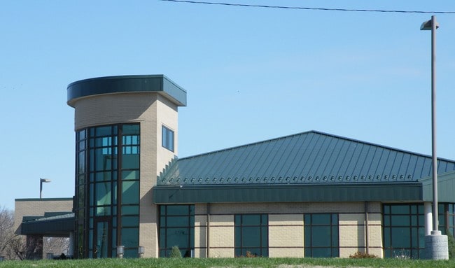
Property Record
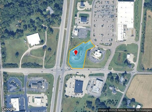
12717 Highway 41 N, Evansville, IN 47725
NEARBY LISTINGS FOR SALE OR LEASE
Property Detail
12717 Highway 41 N
Evansville, IN-KY
Schnucks North Sub
82-04-08-009-385.004-030
SCHNUCKS NORTH SUB LOT 4
Financialbuilding
Vanderburgh
X
Indiana
18163C0106D
4
2024
1.45 AC
2024
Northside/Airport
010702
Evansville
3,443 SF
DEMOGRAPHICS near 12717 Highway 41 N
1 Mile
3 Mile
5 Mile
2024 Total Population
1,105
14,900
35,184
2029 Population
1,103
14,819
34,968
Pop Growth 2024-2029
(0.18%)
(0.54%)
(0.61%)
Average Age
44
41
41
2024 Total Households
423
5,527
13,368
HH Growth 2024-2029
(0.24%)
(0.54%)
(0.62%)
Median Household Inc
$100,521
$97,542
$86,952
Avg Household Size
2.60
2.70
2.60
2024 Avg HH Vehicles
2.00
2.00
2.00
Median Home Value
$284,506
$258,576
$212,785
Median Year Built
1989
1995
1991
Nearby Places
Map Layers
Map Styles
 Street
 Aerial
- Restaurants
- Banks
- Shops
- Fitness
- Groceries
PUBLIC TRANSPORTATION
AIRPORT
Evansville Regional
DRIVE
WALK
Distance
Evansville Regional
11 min
5.9 mi
Freight Ports
Port of Toledo
DRIVE
WALK
Distance
Port of Toledo
449 min
385.9 mi
Nearby Properties
Address
Land Use
TOTAL SIZE
Lot Size
Zoning
Address
Land Use
TOTAL SIZE
Lot Size
Zoning
1,785 SF
70.87 AC
5
Address
Land Use
TOTAL SIZE
Lot Size
Zoning
253,580 SF
41.82 AC
5
Address
Land Use
TOTAL SIZE
Lot Size
Zoning
990 SF
48.21 AC
Address
Land Use
TOTAL SIZE
Lot Size
Zoning
73,423 SF
9.97 AC
Address
Land Use
TOTAL SIZE
Lot Size
Zoning
55,870 SF
6.30 AC
Address
Land Use
TOTAL SIZE
Lot Size
Zoning
31,669 SF
8.55 AC
Address
Land Use
TOTAL SIZE
Lot Size
Zoning
227,968 SF
11.05 AC
Address
Land Use
TOTAL SIZE
Lot Size
Zoning
9,250 SF
8.57 AC
Address
Land Use
TOTAL SIZE
Lot Size
Zoning
46,876 SF
12.78 AC
Address
Land Use
TOTAL SIZE
Lot Size
Zoning
50,751 SF
7.04 AC
4
Address
Land Use
TOTAL SIZE
Lot Size
Zoning
22,794 SF
6.39 AC
Address
Land Use
TOTAL SIZE
Lot Size
Zoning
143,507 SF
27.98 AC
55
Address
Land Use
TOTAL SIZE
Lot Size
Zoning
18,117 SF
12.41 AC
Address
Land Use
TOTAL SIZE
Lot Size
Zoning
1,200 SF
26 AC
Address
Land Use
TOTAL SIZE
Lot Size
Zoning
8,740 SF
5.97 AC
4
Address
Land Use
TOTAL SIZE
Lot Size
Zoning
30,270 SF
2.84 AC
Address
Land Use
TOTAL SIZE
Lot Size
Zoning
22,964 SF
15.73 AC
Address
Land Use
TOTAL SIZE
Lot Size
Zoning
3,591 SF
1.62 AC
Address
Land Use
TOTAL SIZE
Lot Size
Zoning
40,713 SF
16.45 AC
Address
Land Use
TOTAL SIZE
Lot Size
Zoning
34,020 SF
2.67 AC
Address
Land Use
TOTAL SIZE
Lot Size
Zoning
15,359 SF
2.43 AC
Address
Land Use
TOTAL SIZE
Lot Size
Zoning
49,160 SF
12.42 AC
4
Address
Land Use
TOTAL SIZE
Lot Size
Zoning
13,334 SF
1.69 AC
1
Address
Land Use
TOTAL SIZE
Lot Size
Zoning
15,210 SF
7.22 AC
Address
Land Use
TOTAL SIZE
Lot Size
Zoning
26,000 SF
8.29 AC
Address
Land Use
TOTAL SIZE
Lot Size
Zoning
22,562 SF
9.28 AC
Address
Land Use
TOTAL SIZE
Lot Size
Zoning
31,005 SF
3.31 AC
Address
Land Use
TOTAL SIZE
Lot Size
Zoning
5,626 SF
1.91 AC
Address
Land Use
TOTAL SIZE
Lot Size
Zoning
45,000 SF
3.87 AC
5
The World's #1 Commercial Real Estate Marketplace
Connect with us
© 2025 CoStar Group
The information above has been obtained from sources believed reliable. While we do not doubt its accuracy we have not verified it and make no guarantee, warranty or representation about it. It is your responsibility to independently confirm its accuracy and completeness. Any projections, opinions, assumptions, or estimates used are for example only and do not represent the current or future performance of the property. The value of this transaction to you depends on tax and other factors which should be evaluated by your tax, financial, and legal advisors. You and your advisors should conduct a careful, independent investigation of the property to determine to your satisfaction the suitability of the property for your needs.