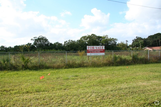
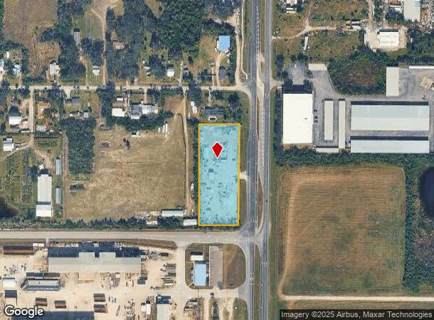
Property Record
12719 S 41 Hwy, Gibsonton, FL 33534
NEARBY LISTINGS FOR SALE OR LEASE
Property Detail
12719 S 41 Hwy
Tampa-St. Petersburg-Clearwater, FL
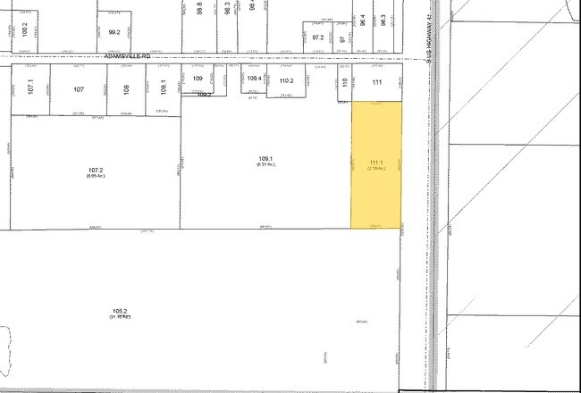
Florida Garden Lands Revised Map Of
U-03-31-19-1RR-000000-00111.1
FLORIDA GARDEN LANDS REVISED MAP OF S 490 FT OF N 653.5 FT OF LOT 111 LESS HWY
Privatepreserveopenspacevacantlandforestlandconservation
Hillsborough
AE
Florida
12057C0492J
111
2024
2.19 AC
2024
Southeast Hillsborough
013804
Tampa/St Petersburg
296 SF
DEMOGRAPHICS near 12719 S 41 Hwy
1 Mile
3 Mile
5 Mile
2024 Total Population
1,542
35,016
125,672
2029 Population
1,689
38,673
139,520
Pop Growth 2024-2029
+ 9.53%
+ 10.44%
+ 11.02%
Average Age
34
36
37
2024 Total Households
500
11,957
43,926
HH Growth 2024-2029
+ 9.80%
+ 10.75%
+ 11.24%
Median Household Inc
$64,459
$85,776
$88,185
Avg Household Size
3.00
2.90
2.80
2024 Avg HH Vehicles
2.00
2.00
2.00
Median Home Value
$208,500
$271,512
$289,955
Median Year Built
1992
2006
2008
Nearby Places
Map Layers
Map Styles
 Street
 Aerial
- Restaurants
- Banks
- Shops
- Fitness
- Groceries
PUBLIC TRANSPORTATION
AIRPORT
Tampa International
DRIVE
WALK
Distance
Tampa International
35 min
22.5 mi
St Pete-Clearwater International
DRIVE
WALK
Distance
St Pete-Clearwater International
52 min
31.7 mi
Freight Ports
Port of Tampa Bay
DRIVE
WALK
Distance
Port of Tampa Bay
19 min
11.8 mi
Nearby Properties
Address
Land Use
TOTAL SIZE
Lot Size
Zoning
Address
Land Use
TOTAL SIZE
Lot Size
Zoning
647,720 SF
68.52 AC
PD
Address
Land Use
TOTAL SIZE
Lot Size
Zoning
503,703 SF
21 AC
PD
Address
Land Use
TOTAL SIZE
Lot Size
Zoning
493,204 SF
65.35 AC
M
Address
Land Use
TOTAL SIZE
Lot Size
Zoning
593,167 SF
416.07 AC
M
Address
Land Use
TOTAL SIZE
Lot Size
Zoning
334,871 SF
15 AC
PD
Address
Land Use
TOTAL SIZE
Lot Size
Zoning
347,147 SF
258.94 AC
PD
Address
Land Use
TOTAL SIZE
Lot Size
Zoning
425,231 SF
23.78 AC
M
Address
Land Use
TOTAL SIZE
Lot Size
Zoning
146,440 SF
18.56 AC
PD
Address
Land Use
TOTAL SIZE
Lot Size
Zoning
48,968 SF
10 AC
PD
Address
Land Use
TOTAL SIZE
Lot Size
Zoning
520,366 SF
122.24 AC
PD
Address
Land Use
TOTAL SIZE
Lot Size
Zoning
441,257 SF
107.09 AC
AR
Address
Land Use
TOTAL SIZE
Lot Size
Zoning
178,496 SF
17.63 AC
PD
Address
Land Use
TOTAL SIZE
Lot Size
Zoning
64,512 SF
22.33 AC
PD
Address
Land Use
TOTAL SIZE
Lot Size
Zoning
93,256 SF
14.82 AC
PD
Address
Land Use
TOTAL SIZE
Lot Size
Zoning
108,036 SF
11.70 AC
PD
Address
Land Use
TOTAL SIZE
Lot Size
Zoning
88,445 SF
14.41 AC
PD
Address
Land Use
TOTAL SIZE
Lot Size
Zoning
81,193 SF
11.41 AC
PD
Address
Land Use
TOTAL SIZE
Lot Size
Zoning
110,148 SF
23.04 AC
M
Address
Land Use
TOTAL SIZE
Lot Size
Zoning
924 SF
563.45 AC
AR
Address
Land Use
TOTAL SIZE
Lot Size
Zoning
40,676 SF
8.56 AC
M
Address
Land Use
TOTAL SIZE
Lot Size
Zoning
76,280 SF
3.87 AC
PD
Address
Land Use
TOTAL SIZE
Lot Size
Zoning
123,538 SF
8.88 AC
M
Address
Land Use
TOTAL SIZE
Lot Size
Zoning
57,822 SF
47.69 AC
AR
Address
Land Use
TOTAL SIZE
Lot Size
Zoning
35,795 SF
48.06 AC
AI
Address
Land Use
TOTAL SIZE
Lot Size
Zoning
78,323 SF
7.19 AC
IPD-1
Address
Land Use
TOTAL SIZE
Lot Size
Zoning
122.18 AC
PD
Address
Land Use
TOTAL SIZE
Lot Size
Zoning
87,068 SF
24.86 AC
PD
Address
Land Use
TOTAL SIZE
Lot Size
Zoning
86,761 SF
13.92 AC
M
Address
Land Use
TOTAL SIZE
Lot Size
Zoning
49,279 SF
3.73 AC
PD
The World's #1 Commercial Real Estate Marketplace
Connect with us
© 2025 CoStar Group
The information above has been obtained from sources believed reliable. While we do not doubt its accuracy we have not verified it and make no guarantee, warranty or representation about it. It is your responsibility to independently confirm its accuracy and completeness. Any projections, opinions, assumptions, or estimates used are for example only and do not represent the current or future performance of the property. The value of this transaction to you depends on tax and other factors which should be evaluated by your tax, financial, and legal advisors. You and your advisors should conduct a careful, independent investigation of the property to determine to your satisfaction the suitability of the property for your needs.