Property Record
12719 W H, Biola, CA 93606
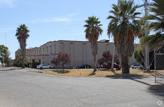


Property Detail
12719 W H
016-190-63
3.25 ACS IN BLK 50 & 53 BIOLA ACRES
Warehouse
FRESNO
M1
California
B and X Area of moderate flood hazard, usually the area between the limits of the 100-year and 500-year floods.
1
2025
3.25 AC
2025
Outlying Fresno Cnty
004100
Fresno
44,739 SF
Fresno, CA
NEARBY LISTINGS FOR SALE OR LEASE
-
-
View all Biola listings for sale on LoopNet.com
DEMOGRAPHICS near 12719 W H
1 mile
3 mile
5 mile
2025 Total Population
1,044
2,308
5,037
2030 Population
965
2,186
4,909
Pop Growth 2025-2030
(7.57%)
(5.29%)
(2.54%)
Average Age
33
36
37
2025 Total Households
262
642
1,489
HH Growth 2025-2030
(8.02%)
(5.30%)
(2.48%)
Median Household Inc
$43,308
$58,614
$64,741
Avg Household Size
3.70
3.40
3.30
2025 Avg HH Vehicles
2.00
2.00
2.00
Median Home Value
$311,111
$413,095
$457,257
Median Year Built
2002
1982
1979
Nearby Places
Map Layers
Map Styles
 Street
 Aerial
Transit
 Traffic
 Biking
Places
Listings with unknown addresses are not visible on the map
- Restaurants
- Banks
- Shops
- Fitness
- Groceries
PUBLIC TRANSPORTATION
AIRPORT
Fresno Yosemite International
Drive
Walk
Distance
Fresno Yosemite International
38 min
18.3 mi
Freight Ports
Port of Stockton
Drive
Walk
Distance
Port of Stockton
149 min
118.8 mi
Nearby Properties
Address
Land Use
TOTAL SIZE
Lot Size
Zoning
Address
Land Use
TOTAL SIZE
Lot Size
Zoning
44,635 SF
8.10 AC
M3
Address
Land Use
TOTAL SIZE
Lot Size
Zoning
11,107 SF
3.92 AC
M1
Address
Land Use
TOTAL SIZE
Lot Size
Zoning
8,800 SF
16.12 AC
AE20
Address
Land Use
TOTAL SIZE
Lot Size
Zoning
1,125 SF
27.40 AC
AE20
Address
Land Use
TOTAL SIZE
Lot Size
Zoning
2,036 SF
317.51 AC
AE20
Address
Land Use
TOTAL SIZE
Lot Size
Zoning
51,268 SF
4.83 AC
R2
Address
Land Use
TOTAL SIZE
Lot Size
Zoning
103,686 SF
9.30 AC
AE20
Address
Land Use
TOTAL SIZE
Lot Size
Zoning
1,729 SF
78.20 AC
ARE-20
Address
Land Use
TOTAL SIZE
Lot Size
Zoning
37.53 AC
AE20
Address
Land Use
TOTAL SIZE
Lot Size
Zoning
3,885 SF
3.30 AC
ARE-20
Address
Land Use
TOTAL SIZE
Lot Size
Zoning
6,898 SF
38.48 AC
AE20
Address
Land Use
TOTAL SIZE
Lot Size
Zoning
19,584 SF
2.77 AC
Address
Land Use
TOTAL SIZE
Lot Size
Zoning
28.92 AC
Address
Land Use
TOTAL SIZE
Lot Size
Zoning
810 SF
40 AC
AE20
Address
Land Use
TOTAL SIZE
Lot Size
Zoning
1,680 SF
80 AC
AE20
Address
Land Use
TOTAL SIZE
Lot Size
Zoning
3,303 SF
22.92 AC
AE20
Address
Land Use
TOTAL SIZE
Lot Size
Zoning
5,468 SF
5 AC
Address
Land Use
TOTAL SIZE
Lot Size
Zoning
1,954 SF
51.26 AC
AE20
Address
Land Use
TOTAL SIZE
Lot Size
Zoning
44.13 AC
ARE-20
Address
Land Use
TOTAL SIZE
Lot Size
Zoning
1,984 SF
64.93 AC
ARE-20
Address
Land Use
TOTAL SIZE
Lot Size
Zoning
1,977 SF
40 AC
AE20
Address
Land Use
TOTAL SIZE
Lot Size
Zoning
52.48 AC
ARE-40
Address
Land Use
TOTAL SIZE
Lot Size
Zoning
1,110 SF
34.98 AC
AE20
Address
Land Use
TOTAL SIZE
Lot Size
Zoning
1,056 SF
50.04 AC
AE20
Address
Land Use
TOTAL SIZE
Lot Size
Zoning
2,172 SF
52.14 AC
ARE-20
Address
Land Use
TOTAL SIZE
Lot Size
Zoning
1,358 SF
40 AC
AE20
Address
Land Use
TOTAL SIZE
Lot Size
Zoning
2,862 SF
18.49 AC
ARE-20
Address
Land Use
TOTAL SIZE
Lot Size
Zoning
2,002 SF
33.93 AC
ARE-20
Address
Land Use
TOTAL SIZE
Lot Size
Zoning
1,092 SF
155.40 AC
AE20
The World's #1 Commercial Real Estate Marketplace
Connect with us
© 2026 CoStar Group
The information above has been obtained from sources believed reliable. While we do not doubt its accuracy we have not verified it and make no guarantee, warranty or representation about it. It is your responsibility to independently confirm its accuracy and completeness. Any projections, opinions, assumptions, or estimates used are for example only and do not represent the current or future performance of the property. The value of this transaction to you depends on tax and other factors which should be evaluated by your tax, financial, and legal advisors. You and your advisors should conduct a careful, independent investigation of the property to determine to your satisfaction the suitability of the property for your needs.