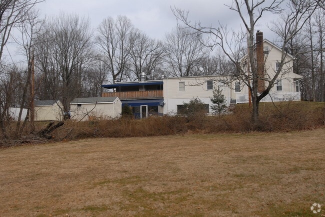
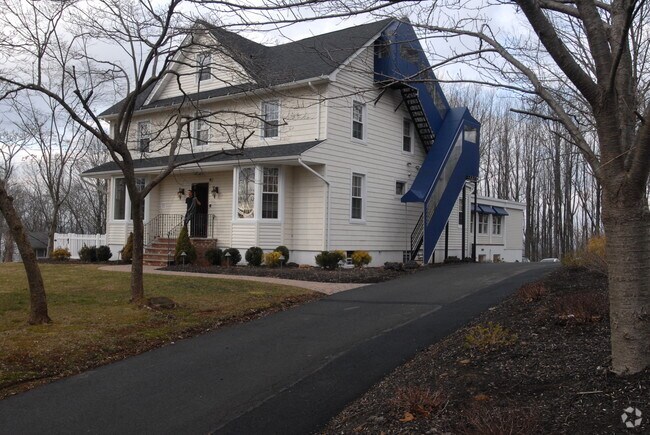
Property Record
1272 Long Hill Rd, Stirling, NJ 07980

NEARBY LISTINGS FOR SALE OR LEASE
Property Detail
1272 Long Hill Rd
Newark, NJ-PA
Morris
30-14204-0000-00070
New Jersey
Hospitalpublic
70
2024
1.45 AC
2025
Morristown Region
044101
Northern New Jersey
6,618 SF
DEMOGRAPHICS near 1272 Long Hill Rd
1 Mile
3 Mile
5 Mile
2024 Total Population
2,925
23,875
82,879
2029 Population
2,923
23,956
82,880
Pop Growth 2024-2029
(0.07%)
+ 0.34%
0.00%
Average Age
42
43
43
2024 Total Households
1,053
8,588
29,688
HH Growth 2024-2029
0.00%
+ 0.30%
(0.11%)
Median Household Inc
$140,099
$151,503
$148,810
Avg Household Size
2.80
2.70
2.70
2024 Avg HH Vehicles
2.00
2.00
2.00
Median Home Value
$683,159
$700,716
$722,687
Median Year Built
1960
1977
1973
Nearby Places
Map Layers
Map Styles
 Street
 Aerial
- Restaurants
- Banks
- Shops
- Fitness
- Groceries
PUBLIC TRANSPORTATION
COMMUTER RAIL
Stirling (Morris & Essex Gladstone Branch - NJ Transit Commuter Rail (NJ Transit))
DRIVE
WALK
Distance
Stirling (Morris & Essex Gladstone Branch - NJ Transit Commuter Rail (NJ Transit))
2 min
11 min
0.6 mi
Millington (Morris & Essex Gladstone Branch - NJ Transit Commuter Rail (NJ Transit))
DRIVE
WALK
Distance
Millington (Morris & Essex Gladstone Branch - NJ Transit Commuter Rail (NJ Transit))
3 min
1.6 mi
AIRPORT
Newark Liberty International
DRIVE
WALK
Distance
Newark Liberty International
33 min
23.6 mi
Freight Ports
New York Container Terminal
DRIVE
WALK
Distance
New York Container Terminal
43 min
26.6 mi
Nearby Properties
Address
Land Use
TOTAL SIZE
Lot Size
Zoning
Address
Land Use
TOTAL SIZE
Lot Size
Zoning
52.31 AC
OR
Address
Land Use
TOTAL SIZE
Lot Size
Zoning
1,976 SF
22.03 AC
B5
Address
Land Use
TOTAL SIZE
Lot Size
Zoning
67.22 AC
R65
Address
Land Use
TOTAL SIZE
Lot Size
Zoning
839.97 AC
P1
Address
Land Use
TOTAL SIZE
Lot Size
Zoning
23.93 AC
B2
Address
Land Use
TOTAL SIZE
Lot Size
Zoning
34.78 AC
P3
Address
Land Use
TOTAL SIZE
Lot Size
Zoning
8.64 AC
AH-4
Address
Land Use
TOTAL SIZE
Lot Size
Zoning
11.66 AC
R6
Address
Land Use
TOTAL SIZE
Lot Size
Zoning
1,096 SF
15.12 AC
R5
Address
Land Use
TOTAL SIZE
Lot Size
Zoning
8.09 AC
B3
Address
Land Use
TOTAL SIZE
Lot Size
Zoning
30.84 AC
OR
Address
Land Use
TOTAL SIZE
Lot Size
Zoning
2,765 SF
9.10 AC
R6
Address
Land Use
TOTAL SIZE
Lot Size
Zoning
40.73 AC
OR
Address
Land Use
TOTAL SIZE
Lot Size
Zoning
1,950 SF
10.56 AC
CR
Address
Land Use
TOTAL SIZE
Lot Size
Zoning
2.71 AC
CR
Address
Land Use
TOTAL SIZE
Lot Size
Zoning
5,120 SF
179.76 AC
M-1
Address
Land Use
TOTAL SIZE
Lot Size
Zoning
6.92 AC
B2
Address
Land Use
TOTAL SIZE
Lot Size
Zoning
18.30 AC
R6
Address
Land Use
TOTAL SIZE
Lot Size
Zoning
7.46 AC
BR80
Address
Land Use
TOTAL SIZE
Lot Size
Zoning
30.26 AC
C
Address
Land Use
TOTAL SIZE
Lot Size
Zoning
21.30 AC
OL
Address
Land Use
TOTAL SIZE
Lot Size
Zoning
4.42 AC
C
Address
Land Use
TOTAL SIZE
Lot Size
Zoning
1,038 SF
18.68 AC
P1
Address
Land Use
TOTAL SIZE
Lot Size
Zoning
22,056 SF
5.22 AC
R6
Address
Land Use
TOTAL SIZE
Lot Size
Zoning
14.22 AC
B3
Address
Land Use
TOTAL SIZE
Lot Size
Zoning
22,391 SF
28.31 AC
P1
Address
Land Use
TOTAL SIZE
Lot Size
Zoning
2.13 AC
RMF3
Address
Land Use
TOTAL SIZE
Lot Size
Zoning
2.30 AC
RMF3
Address
Land Use
TOTAL SIZE
Lot Size
Zoning
11.90 AC
LI2
Address
Land Use
TOTAL SIZE
Lot Size
Zoning
2.83 AC
NB
The World's #1 Commercial Real Estate Marketplace
Connect with us
© 2025 CoStar Group
The information above has been obtained from sources believed reliable. While we do not doubt its accuracy we have not verified it and make no guarantee, warranty or representation about it. It is your responsibility to independently confirm its accuracy and completeness. Any projections, opinions, assumptions, or estimates used are for example only and do not represent the current or future performance of the property. The value of this transaction to you depends on tax and other factors which should be evaluated by your tax, financial, and legal advisors. You and your advisors should conduct a careful, independent investigation of the property to determine to your satisfaction the suitability of the property for your needs.