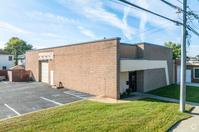
Property Record
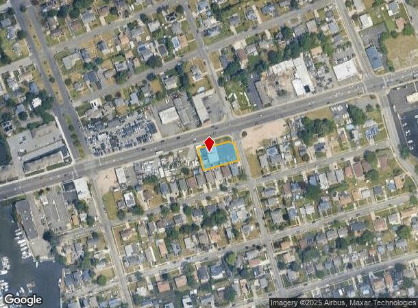
1272 Merrick Rd, Copiague, NY 11726
NEARBY LISTINGS FOR SALE OR LEASE
Property Detail
1272 Merrick Rd
Nassau County-Suffolk County, NY
Map Amending Section #1 Map American Ven
0100-189-00-01-00-117-003
FM 224 SEC 1 BL 1 P/O LTS 23-30 INC
Commercialnec
Suffolk
X
New York
36103C0842H
117
2024
0.33 AC
2024
Southwest Suffolk
123802
Long Island (New York)
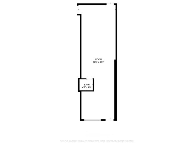
5,661 SF
DEMOGRAPHICS near 1272 Merrick Rd
1 Mile
3 Mile
5 Mile
2024 Total Population
19,642
104,137
226,099
2029 Population
19,075
101,744
221,267
Pop Growth 2024-2029
(2.89%)
(2.30%)
(2.14%)
Average Age
42
42
41
2024 Total Households
6,879
34,858
75,285
HH Growth 2024-2029
(3.01%)
(2.51%)
(2.33%)
Median Household Inc
$97,831
$104,577
$114,883
Avg Household Size
2.80
2.90
2.90
2024 Avg HH Vehicles
2.00
2.00
2.00
Median Home Value
$426,133
$452,407
$488,650
Median Year Built
1960
1961
1958
Nearby Places
- Restaurants
- Banks
- Shops
- Fitness
- Groceries
PUBLIC TRANSPORTATION
COMMUTER RAIL
Copiague Station (Babylon Branch - Long Island Rail Road)
DRIVE
WALK
Distance
Copiague Station (Babylon Branch - Long Island Rail Road)
2 min
1.4 mi
Lindenhurst Station (Babylon Branch - Long Island Rail Road)
DRIVE
WALK
Distance
Lindenhurst Station (Babylon Branch - Long Island Rail Road)
4 min
2.4 mi
AIRPORT
Long Island MacArthur
DRIVE
WALK
Distance
Long Island MacArthur
30 min
20.2 mi
John F Kennedy International
DRIVE
WALK
Distance
John F Kennedy International
35 min
24.4 mi
LaGuardia
DRIVE
WALK
Distance
LaGuardia
46 min
31.4 mi
Freight Ports
NY - Red Hook Container Terminal
DRIVE
WALK
Distance
NY - Red Hook Container Terminal
56 min
35.9 mi
SALE & LEASE HISTORY
LISTING DATE
SALE/LEASE

Jan 21, 2025
For Lease
Dec 27, 2016
For Sale
Dec 18, 2020
For Lease
Apr 17, 2017
For Sale
Nearby Properties
Address
Land Use
TOTAL SIZE
Lot Size
Zoning
Address
Land Use
TOTAL SIZE
Lot Size
Zoning
12,920 SF
1.90 AC
R60
Address
Land Use
TOTAL SIZE
Lot Size
Zoning
9.95 AC
BUS3
Address
Land Use
TOTAL SIZE
Lot Size
Zoning
24.90 AC
B
Address
Land Use
TOTAL SIZE
Lot Size
Zoning
3,518 SF
0.44 AC
VILLA
Address
Land Use
TOTAL SIZE
Lot Size
Zoning
6.37 AC
BUS3
Address
Land Use
TOTAL SIZE
Lot Size
Zoning
2,520 SF
0.89 AC
HC
Address
Land Use
TOTAL SIZE
Lot Size
Zoning
1.70 AC
R40
Address
Land Use
TOTAL SIZE
Lot Size
Zoning
5,010 SF
0.30 AC
R10
Address
Land Use
TOTAL SIZE
Lot Size
Zoning
22.10 AC
Address
Land Use
TOTAL SIZE
Lot Size
Zoning
0.99 AC
HB
Address
Land Use
TOTAL SIZE
Lot Size
Zoning
0.90 AC
HC
Address
Land Use
TOTAL SIZE
Lot Size
Zoning
7.15 AC
Address
Land Use
TOTAL SIZE
Lot Size
Zoning
6,891 SF
0.75 AC
HC
Address
Land Use
TOTAL SIZE
Lot Size
Zoning
13.63 AC
B
Address
Land Use
TOTAL SIZE
Lot Size
Zoning
205,948 SF
15.21 AC
Address
Land Use
TOTAL SIZE
Lot Size
Zoning
3,700 SF
43.04 AC
Address
Land Use
TOTAL SIZE
Lot Size
Zoning
Address
Land Use
TOTAL SIZE
Lot Size
Zoning
44 AC
E
Address
Land Use
TOTAL SIZE
Lot Size
Zoning
9.68 AC
SC
Address
Land Use
TOTAL SIZE
Lot Size
Zoning
0.46 AC
R40
Address
Land Use
TOTAL SIZE
Lot Size
Zoning
97,594 SF
13.53 AC
Address
Land Use
TOTAL SIZE
Lot Size
Zoning
163.50 AC
A
Address
Land Use
TOTAL SIZE
Lot Size
Zoning
1.70 AC
R60
Address
Land Use
TOTAL SIZE
Lot Size
Zoning
49,004 SF
13.34 AC
Address
Land Use
TOTAL SIZE
Lot Size
Zoning
12.50 AC
C
Address
Land Use
TOTAL SIZE
Lot Size
Zoning
18.30 AC
Address
Land Use
TOTAL SIZE
Lot Size
Zoning
Address
Land Use
TOTAL SIZE
Lot Size
Zoning
108,406 SF
10.21 AC
Address
Land Use
TOTAL SIZE
Lot Size
Zoning
135,605 SF
15.05 AC
E
Address
Land Use
TOTAL SIZE
Lot Size
Zoning
1,450 SF
0.08 AC
The World's #1 Commercial Real Estate Marketplace
Connect with us
© 2025 CoStar Group
The information above has been obtained from sources believed reliable. While we do not doubt its accuracy we have not verified it and make no guarantee, warranty or representation about it. It is your responsibility to independently confirm its accuracy and completeness. Any projections, opinions, assumptions, or estimates used are for example only and do not represent the current or future performance of the property. The value of this transaction to you depends on tax and other factors which should be evaluated by your tax, financial, and legal advisors. You and your advisors should conduct a careful, independent investigation of the property to determine to your satisfaction the suitability of the property for your needs.