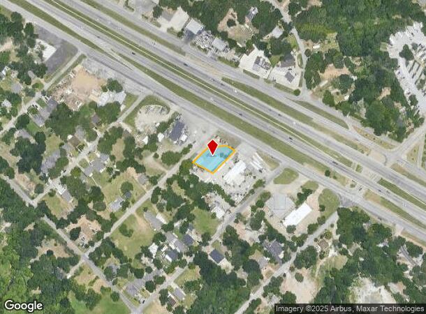
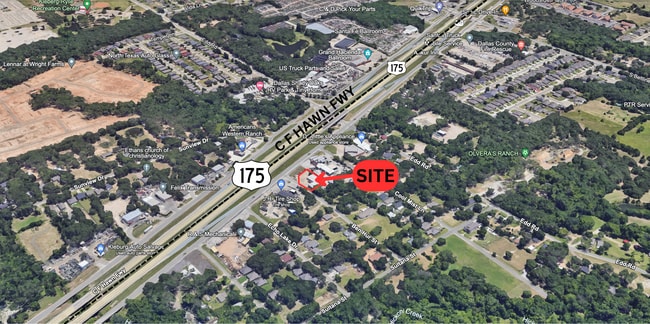
Property Record
12720 C F Hawn Fwy, Dallas, TX 75253
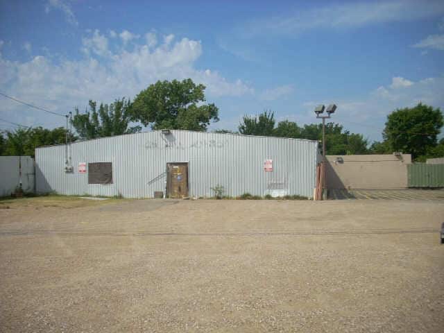

This Property Is For Sale
NEARBY LISTINGS FOR SALE OR LEASE
Property Detail
12720 C F Hawn Fwy
Dallas-Fort Worth-Arlington, TX
Garden Heights Add
00000899752140000
BLK B/8800 LTS 14 & 15 BEN HUR ST INT200900359324 DD1222009 CO-DC 8800 00B 01400 3008800 00B
Autorepair
Dallas
X
Texas
48257C0150E
14,15
2024
0.17 AC
2025
Southeast Outlying
017102
Dallas/Ft Worth
4,125 SF
DEMOGRAPHICS near 12720 C F Hawn Fwy
1 Mile
3 Mile
5 Mile
2024 Total Population
6,390
57,220
129,594
2029 Population
6,386
57,560
129,374
Pop Growth 2024-2029
(0.06%)
+ 0.59%
(0.17%)
Average Age
33
32
33
2024 Total Households
1,839
15,940
36,204
HH Growth 2024-2029
(0.16%)
+ 0.44%
(0.35%)
Median Household Inc
$49,440
$52,540
$53,427
Avg Household Size
3.40
3.50
3.40
2024 Avg HH Vehicles
2.00
2.00
2.00
Median Home Value
$187,527
$168,556
$168,774
Median Year Built
1987
1991
1986
Nearby Places
- Restaurants
- Banks
- Shops
- Fitness
- Groceries
PUBLIC TRANSPORTATION
AIRPORT
Dallas Love Field
DRIVE
WALK
Distance
Dallas Love Field
29 min
19.9 mi
Dallas-Fort Worth International
DRIVE
WALK
Distance
Dallas-Fort Worth International
44 min
35.8 mi
Freight Ports
Port of Shreveport
DRIVE
WALK
Distance
Port of Shreveport
199 min
185.3 mi
Nearby Properties
Address
Land Use
TOTAL SIZE
Lot Size
Zoning
Address
Land Use
TOTAL SIZE
Lot Size
Zoning
457,110 SF
100.05 AC
Z293
Address
Land Use
TOTAL SIZE
Lot Size
Zoning
290,916 SF
8.24 AC
Address
Land Use
TOTAL SIZE
Lot Size
Zoning
257,696 SF
9.62 AC
Address
Land Use
TOTAL SIZE
Lot Size
Zoning
372,456 SF
17.34 AC
Z116
Address
Land Use
TOTAL SIZE
Lot Size
Zoning
400 SF
50.76 AC
MFA
Address
Land Use
TOTAL SIZE
Lot Size
Zoning
141,566 SF
23 AC
Z298
Address
Land Use
TOTAL SIZE
Lot Size
Zoning
238,728 SF
12.31 AC
Z184
Address
Land Use
TOTAL SIZE
Lot Size
Zoning
234,459 SF
9.71 AC
Z138
Address
Land Use
TOTAL SIZE
Lot Size
Zoning
321 SF
40.51 AC
MFA
Address
Land Use
TOTAL SIZE
Lot Size
Zoning
190,150 SF
13.39 AC
Z236
Address
Land Use
TOTAL SIZE
Lot Size
Zoning
215 SF
29.95 AC
A
Address
Land Use
TOTAL SIZE
Lot Size
Zoning
118,237 SF
5.56 AC
Z183
Address
Land Use
TOTAL SIZE
Lot Size
Zoning
123,790 SF
6.68 AC
Z183
Address
Land Use
TOTAL SIZE
Lot Size
Zoning
248 SF
32.79 AC
MFA
Address
Land Use
TOTAL SIZE
Lot Size
Zoning
160,000 SF
9.60 AC
Z250
Address
Land Use
TOTAL SIZE
Lot Size
Zoning
208 SF
24.50 AC
Z06
Address
Land Use
TOTAL SIZE
Lot Size
Zoning
122,352 SF
6.05 AC
Z46
Address
Land Use
TOTAL SIZE
Lot Size
Zoning
183 SF
23.14 AC
Z06
Address
Land Use
TOTAL SIZE
Lot Size
Zoning
70,000 SF
25.26 AC
Z06
Address
Land Use
TOTAL SIZE
Lot Size
Zoning
96,196 SF
8 AC
Z06
Address
Land Use
TOTAL SIZE
Lot Size
Zoning
106,380 SF
15.82 AC
Z139
Address
Land Use
TOTAL SIZE
Lot Size
Zoning
319 SF
37.74 AC
SUP1
Address
Land Use
TOTAL SIZE
Lot Size
Zoning
150,207 SF
9 AC
Z236
Address
Land Use
TOTAL SIZE
Lot Size
Zoning
72,341 SF
13 AC
Z236
Address
Land Use
TOTAL SIZE
Lot Size
Zoning
191 SF
23.10 AC
Z05
Address
Land Use
TOTAL SIZE
Lot Size
Zoning
146 SF
18.02 AC
MFA
Address
Land Use
TOTAL SIZE
Lot Size
Zoning
130,501 SF
10.37 AC
Z236
Address
Land Use
TOTAL SIZE
Lot Size
Zoning
131,821 SF
8.96 AC
Address
Land Use
TOTAL SIZE
Lot Size
Zoning
156 SF
17.11 AC
MFA
Address
Land Use
TOTAL SIZE
Lot Size
Zoning
96 SF
14.18 AC
I2
The World's #1 Commercial Real Estate Marketplace
Connect with us
© 2025 CoStar Group
The information above has been obtained from sources believed reliable. While we do not doubt its accuracy we have not verified it and make no guarantee, warranty or representation about it. It is your responsibility to independently confirm its accuracy and completeness. Any projections, opinions, assumptions, or estimates used are for example only and do not represent the current or future performance of the property. The value of this transaction to you depends on tax and other factors which should be evaluated by your tax, financial, and legal advisors. You and your advisors should conduct a careful, independent investigation of the property to determine to your satisfaction the suitability of the property for your needs.