No Photo
Property Record
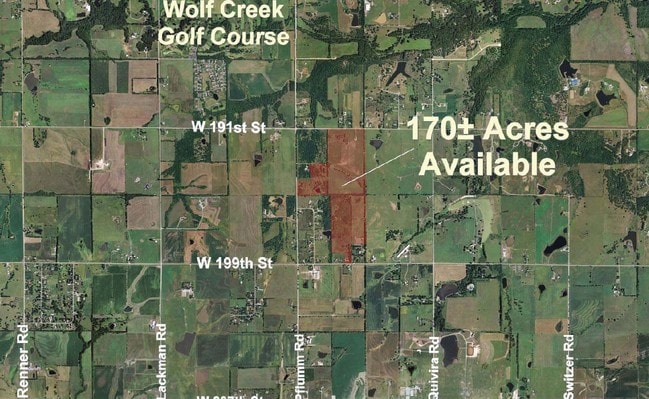
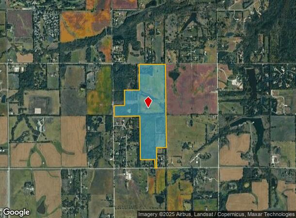
12725 W 191St St, Spring Hill, KS 66083
NEARBY LISTINGS FOR SALE OR LEASE
Property Detail
12725 W 191St St
1F241503-1004
3-15-24 BG NE CR NW1/4 W 1327.31 S 1310.13 W 760.34 S 762.30 W 564.54 S 538.40 E 1322.16 S 2197.96 E 729 S 466.93 E 89.15 N 1045.40 E 500 N 1604.58& 2600.87 TO POB EX .494 AC IN RD 169.6015 ACS M/L
Farms
Johnson
X
Kansas
20091C0141G
168.96 AC
2024
South Johnson County
2024
Kansas City
053804
Kansas City, MO-KS
DEMOGRAPHICS near 12725 W 191St St
1 Mile
3 Mile
5 Mile
2024 Total Population
214
4,876
34,928
2029 Population
227
5,347
37,452
Pop Growth 2024-2029
+ 6.07%
+ 9.66%
+ 7.23%
Average Age
42
41
37
2024 Total Households
71
1,652
11,062
HH Growth 2024-2029
+ 5.63%
+ 9.93%
+ 7.37%
Median Household Inc
$167,307
$157,864
$163,436
Avg Household Size
3.10
2.90
3.10
2024 Avg HH Vehicles
3.00
3.00
3.00
Median Home Value
$586,207
$559,899
$490,959
Median Year Built
1997
2011
2010
Nearby Places
Map Layers
Map Styles
 Street
 Aerial
- Restaurants
- Banks
- Shops
- Fitness
- Groceries
Nearby Properties
Address
Land Use
TOTAL SIZE
Lot Size
Zoning
Address
Land Use
TOTAL SIZE
Lot Size
Zoning
320,892 SF
74.58 AC
R-1
Address
Land Use
TOTAL SIZE
Lot Size
Zoning
143,207 SF
16.19 AC
R-1
Address
Land Use
TOTAL SIZE
Lot Size
Zoning
73,085 SF
18.66 AC
PRN
Address
Land Use
TOTAL SIZE
Lot Size
Zoning
23,766 SF
19.91 AC
RUR
Address
Land Use
TOTAL SIZE
Lot Size
Zoning
7,297 SF
151.69 AC
RURJ
Address
Land Use
TOTAL SIZE
Lot Size
Zoning
163.65 AC
RURJ
Address
Land Use
TOTAL SIZE
Lot Size
Zoning
7,726 SF
4.63 AC
RURJ
Address
Land Use
TOTAL SIZE
Lot Size
Zoning
2,250 SF
91.10 AC
RN1
Address
Land Use
TOTAL SIZE
Lot Size
Zoning
138.23 AC
RURJ
Address
Land Use
TOTAL SIZE
Lot Size
Zoning
5.23 AC
RUR
Address
Land Use
TOTAL SIZE
Lot Size
Zoning
3,456 SF
78.05 AC
RURJ
Address
Land Use
TOTAL SIZE
Lot Size
Zoning
21 AC
R-1
Address
Land Use
TOTAL SIZE
Lot Size
Zoning
79.99 AC
RN1
Address
Land Use
TOTAL SIZE
Lot Size
Zoning
7,860 SF
220.49 AC
RUR
Address
Land Use
TOTAL SIZE
Lot Size
Zoning
1,808 SF
66.42 AC
RN1
Address
Land Use
TOTAL SIZE
Lot Size
Zoning
11.29 AC
R-1
Address
Land Use
TOTAL SIZE
Lot Size
Zoning
4,438 SF
2.83 AC
RLD
Address
Land Use
TOTAL SIZE
Lot Size
Zoning
10,709 SF
2.41 AC
R1
Address
Land Use
TOTAL SIZE
Lot Size
Zoning
11,568 SF
3.99 AC
RUR
Address
Land Use
TOTAL SIZE
Lot Size
Zoning
11,320 SF
154.68 AC
RURJ
Address
Land Use
TOTAL SIZE
Lot Size
Zoning
44.80 AC
RUR
Address
Land Use
TOTAL SIZE
Lot Size
Zoning
20,056 SF
11.64 AC
PRB1J
Address
Land Use
TOTAL SIZE
Lot Size
Zoning
6,500 SF
1.70 AC
CP-2
Address
Land Use
TOTAL SIZE
Lot Size
Zoning
20,415 SF
4.55 AC
PRB1J
Address
Land Use
TOTAL SIZE
Lot Size
Zoning
16,180 SF
30.49 AC
RUR
Address
Land Use
TOTAL SIZE
Lot Size
Zoning
12,854 SF
37.91 AC
RUR
Address
Land Use
TOTAL SIZE
Lot Size
Zoning
11,736 SF
20.06 AC
RUR
Address
Land Use
TOTAL SIZE
Lot Size
Zoning
13,285 SF
31.51 AC
RURJ
Address
Land Use
TOTAL SIZE
Lot Size
Zoning
29.13 AC
RURJ
Address
Land Use
TOTAL SIZE
Lot Size
Zoning
14,284 SF
10.21 AC
RURJ
The World's #1 Commercial Real Estate Marketplace
Connect with us
© 2025 CoStar Group
The information above has been obtained from sources believed reliable. While we do not doubt its accuracy we have not verified it and make no guarantee, warranty or representation about it. It is your responsibility to independently confirm its accuracy and completeness. Any projections, opinions, assumptions, or estimates used are for example only and do not represent the current or future performance of the property. The value of this transaction to you depends on tax and other factors which should be evaluated by your tax, financial, and legal advisors. You and your advisors should conduct a careful, independent investigation of the property to determine to your satisfaction the suitability of the property for your needs.