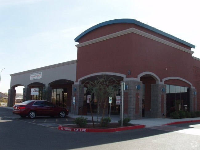
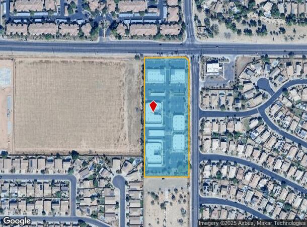
Property Record
12725 W Indian School Rd, Avondale, AZ 85392
NEARBY LISTINGS FOR SALE OR LEASE
Property Detail
12725 W Indian School Rd
501-72-933B
TH PT N2 SEC 26 DAF BEG N4 COR SD SEC TH S 55F TO TPOB TH S 773.25F TH W 289.74F TH N 775.73F TH E 289.75F TO TPOB EX RD P/F 05-1327414
Commercialnec
Maricopa
X
Arizona
04013C2155M
5.15 AC
2025
N Goodyear/Litchfield
2025
Phoenix
061014
Phoenix-Mesa-Scottsdale, AZ
48,981 SF
DEMOGRAPHICS near 12725 W Indian School Rd
1 Mile
3 Mile
5 Mile
2024 Total Population
13,852
94,092
219,968
2029 Population
14,825
102,128
240,554
Pop Growth 2024-2029
+ 7.02%
+ 8.54%
+ 9.36%
Average Age
35
37
36
2024 Total Households
4,612
30,830
71,181
HH Growth 2024-2029
+ 6.96%
+ 8.61%
+ 9.57%
Median Household Inc
$89,398
$89,891
$80,332
Avg Household Size
2.90
3.00
3.00
2024 Avg HH Vehicles
2.00
2.00
2.00
Median Home Value
$344,257
$367,595
$348,229
Median Year Built
2004
2001
2002
Nearby Places
Map Layers
Map Styles
 Street
 Aerial
- Restaurants
- Banks
- Shops
- Fitness
- Groceries
PUBLIC TRANSPORTATION
AIRPORT
Phoenix Sky Harbor International
DRIVE
WALK
Distance
Phoenix Sky Harbor International
35 min
23.7 mi
SALE & LEASE HISTORY
LISTING DATE
SALE/LEASE

Sep 25, 2016
For Lease
Jan 17, 2019
For Lease
Feb 04, 2019
For Lease
Nearby Properties
Address
Land Use
TOTAL SIZE
Lot Size
Zoning
Address
Land Use
TOTAL SIZE
Lot Size
Zoning
Address
Land Use
TOTAL SIZE
Lot Size
Zoning
12.04 AC
Address
Land Use
TOTAL SIZE
Lot Size
Zoning
49,475 SF
5.70 AC
PAD
Address
Land Use
TOTAL SIZE
Lot Size
Zoning
324,374 SF
18.26 AC
PAD
Address
Land Use
TOTAL SIZE
Lot Size
Zoning
52.99 AC
Address
Land Use
TOTAL SIZE
Lot Size
Zoning
401,714 SF
100.01 AC
PAD
Address
Land Use
TOTAL SIZE
Lot Size
Zoning
287,294 SF
67.46 AC
PAD
Address
Land Use
TOTAL SIZE
Lot Size
Zoning
296,791 SF
35 AC
PAD
Address
Land Use
TOTAL SIZE
Lot Size
Zoning
185,870 SF
125.41 AC
S1
Address
Land Use
TOTAL SIZE
Lot Size
Zoning
295,014 SF
37.63 AC
PAD
Address
Land Use
TOTAL SIZE
Lot Size
Zoning
282,993 SF
14.16 AC
PF
Address
Land Use
TOTAL SIZE
Lot Size
Zoning
353,155 SF
16.80 AC
M-H
Address
Land Use
TOTAL SIZE
Lot Size
Zoning
340,061 SF
15.50 AC
M-H
Address
Land Use
TOTAL SIZE
Lot Size
Zoning
328,244 SF
18.44 AC
PAD
Address
Land Use
TOTAL SIZE
Lot Size
Zoning
106,351 SF
20 AC
PAD
Address
Land Use
TOTAL SIZE
Lot Size
Zoning
6,472 SF
1.14 AC
PAD
Address
Land Use
TOTAL SIZE
Lot Size
Zoning
116,236 SF
12.68 AC
PAD
Address
Land Use
TOTAL SIZE
Lot Size
Zoning
109,856 SF
25.18 AC
R-43
Address
Land Use
TOTAL SIZE
Lot Size
Zoning
232,797 SF
25.43 AC
PAD
Address
Land Use
TOTAL SIZE
Lot Size
Zoning
102,431 SF
17.63 AC
R-10
Address
Land Use
TOTAL SIZE
Lot Size
Zoning
181,897 SF
16.71 AC
R-43AG
Address
Land Use
TOTAL SIZE
Lot Size
Zoning
120,289 SF
13.69 AC
C-S
Address
Land Use
TOTAL SIZE
Lot Size
Zoning
291,119 SF
15.38 AC
PAD
Address
Land Use
TOTAL SIZE
Lot Size
Zoning
450,240 SF
25.56 AC
Address
Land Use
TOTAL SIZE
Lot Size
Zoning
299,050 SF
16.29 AC
A1
Address
Land Use
TOTAL SIZE
Lot Size
Zoning
389,952 SF
22.15 AC
Address
Land Use
TOTAL SIZE
Lot Size
Zoning
241,536 SF
7.62 AC
C2
Address
Land Use
TOTAL SIZE
Lot Size
Zoning
132,435 SF
17.43 AC
PAD
Address
Land Use
TOTAL SIZE
Lot Size
Zoning
3,237 SF
1.09 AC
I-1
Address
Land Use
TOTAL SIZE
Lot Size
Zoning
104,974 SF
13.35 AC
PF
The World's #1 Commercial Real Estate Marketplace
Connect with us
© 2026 CoStar Group
The information above has been obtained from sources believed reliable. While we do not doubt its accuracy we have not verified it and make no guarantee, warranty or representation about it. It is your responsibility to independently confirm its accuracy and completeness. Any projections, opinions, assumptions, or estimates used are for example only and do not represent the current or future performance of the property. The value of this transaction to you depends on tax and other factors which should be evaluated by your tax, financial, and legal advisors. You and your advisors should conduct a careful, independent investigation of the property to determine to your satisfaction the suitability of the property for your needs.