Property Record
1147 Butterfield Rd, Wheaton, IL 60189


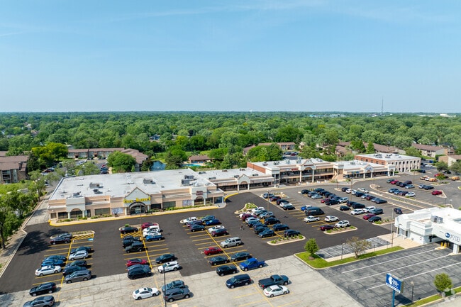
Property Detail
1147 Butterfield Rd
05-27-317-022
BRIARBROOK COMMONS RESUB OF LOT 1 ALL
Commercialnec
DUPAGE
C
Illinois
B and X Area of moderate flood hazard, usually the area between the limits of the 100-year and 500-year floods.
1
2024
5.61 AC
2024
Western East/West Corr
842702
Chicago
80,465 SF
Chicago-Naperville-Elgin, IL-IN
NEARBY LISTINGS FOR SALE OR LEASE
DEMOGRAPHICS near 1147 Butterfield Rd
1 mile
3 mile
5 mile
2025 Total Population
9,979
81,107
244,619
2030 Population
10,079
81,943
247,917
Pop Growth 2025-2030
+ 1.00%
+ 1.03%
+ 1.35%
Average Age
41
41
41
2025 Total Households
4,091
31,233
95,558
HH Growth 2025-2030
+ 0.81%
+ 1.03%
+ 1.42%
Median Household Inc
$118,762
$115,530
$113,195
Avg Household Size
2.40
2.50
2.40
2025 Avg HH Vehicles
2.00
2.00
2.00
Median Home Value
$467,326
$457,331
$440,778
Median Year Built
1978
1975
1976
Nearby Places
Map Layers
Map Styles
 Street
 Aerial
Transit
 Traffic
 Biking
Places
Listings with unknown addresses are not visible on the map
- Restaurants
- Banks
- Shops
- Fitness
- Groceries
PUBLIC TRANSPORTATION
COMMUTER RAIL
Wheaton Station (Union Pacific West Line - Northeast Illinois Regional Commuter Railroad (Metra))
Drive
Walk
Distance
Wheaton Station (Union Pacific West Line - Northeast Illinois Regional Commuter Railroad (Metra))
8 min
3.8 mi
Lisle Station (Burlington Northern-Santa Fe Railway Line - Northeast Illinois Regional Commuter Railroad (Metra))
Drive
Walk
Distance
Lisle Station (Burlington Northern-Santa Fe Railway Line - Northeast Illinois Regional Commuter Railroad (Metra))
11 min
4.0 mi
AIRPORT
Chicago Midway International
Drive
Walk
Distance
Chicago Midway International
36 min
21.6 mi
Chicago O'Hare International
Drive
Walk
Distance
Chicago O'Hare International
35 min
22.5 mi
Freight Ports
Port Milwaukee
Drive
Walk
Distance
Port Milwaukee
117 min
94.2 mi
SALE & LEASE HISTORY
LISTING DATE
SALE/LEASE

Sep 24, 2016
For Lease
Oct 29, 2018
For Lease
Nov 07, 2017
For Sale
Jul 05, 2020
For Sale
Dec 06, 2021
For Lease
Aug 29, 2018
For Lease
Aug 28, 2019
For Lease
Apr 20, 2021
For Sale
Apr 09, 2019
For Lease
Apr 08, 2019
For Sale
Nearby Properties
Address
Land Use
TOTAL SIZE
Lot Size
Zoning
Address
Land Use
TOTAL SIZE
Lot Size
Zoning
818,262 SF
13.70 AC
M
Address
Land Use
TOTAL SIZE
Lot Size
Zoning
83.99 AC
Address
Land Use
TOTAL SIZE
Lot Size
Zoning
594,125 SF
2.60 AC
Address
Land Use
TOTAL SIZE
Lot Size
Zoning
534,583 SF
16.04 AC
C
Address
Land Use
TOTAL SIZE
Lot Size
Zoning
376,629 SF
16.26 AC
C
Address
Land Use
TOTAL SIZE
Lot Size
Zoning
Address
Land Use
TOTAL SIZE
Lot Size
Zoning
8.08 AC
C
Address
Land Use
TOTAL SIZE
Lot Size
Zoning
Address
Land Use
TOTAL SIZE
Lot Size
Zoning
295,773 SF
17.45 AC
M
Address
Land Use
TOTAL SIZE
Lot Size
Zoning
264,227 SF
17.12 AC
M
Address
Land Use
TOTAL SIZE
Lot Size
Zoning
254,992 SF
14.21 AC
M
Address
Land Use
TOTAL SIZE
Lot Size
Zoning
300,104 SF
19.49 AC
M
Address
Land Use
TOTAL SIZE
Lot Size
Zoning
254,201 SF
27.84 AC
Address
Land Use
TOTAL SIZE
Lot Size
Zoning
20.05 AC
C
Address
Land Use
TOTAL SIZE
Lot Size
Zoning
9.18 AC
C
Address
Land Use
TOTAL SIZE
Lot Size
Zoning
8.36 AC
C
Address
Land Use
TOTAL SIZE
Lot Size
Zoning
552,111 SF
4.48 AC
C
Address
Land Use
TOTAL SIZE
Lot Size
Zoning
201,048 SF
20.24 AC
Address
Land Use
TOTAL SIZE
Lot Size
Zoning
146,492 SF
0.42 AC
Address
Land Use
TOTAL SIZE
Lot Size
Zoning
259,374 SF
27.66 AC
C
Address
Land Use
TOTAL SIZE
Lot Size
Zoning
2.37 AC
Address
Land Use
TOTAL SIZE
Lot Size
Zoning
13.67 AC
M
Address
Land Use
TOTAL SIZE
Lot Size
Zoning
14.68 AC
I
Address
Land Use
TOTAL SIZE
Lot Size
Zoning
16.26 AC
C
Address
Land Use
TOTAL SIZE
Lot Size
Zoning
13.89 AC
M
Address
Land Use
TOTAL SIZE
Lot Size
Zoning
162,819 SF
19.82 AC
C
Address
Land Use
TOTAL SIZE
Lot Size
Zoning
13.27 AC
M
Address
Land Use
TOTAL SIZE
Lot Size
Zoning
162,815 SF
11.60 AC
M
Address
Land Use
TOTAL SIZE
Lot Size
Zoning
13.44 AC
C
Address
Land Use
TOTAL SIZE
Lot Size
Zoning
240,918 SF
8.13 AC
C
The World's #1 Commercial Real Estate Marketplace
Connect with us
© 2026 CoStar Group
The information above has been obtained from sources believed reliable. While we do not doubt its accuracy we have not verified it and make no guarantee, warranty or representation about it. It is your responsibility to independently confirm its accuracy and completeness. Any projections, opinions, assumptions, or estimates used are for example only and do not represent the current or future performance of the property. The value of this transaction to you depends on tax and other factors which should be evaluated by your tax, financial, and legal advisors. You and your advisors should conduct a careful, independent investigation of the property to determine to your satisfaction the suitability of the property for your needs.