Property Record
1275 E Harvester Rd, Columbia, MO 65202
NEARBY LISTINGS FOR SALE OR LEASE
-
-
View all Columbia listings for lease on LoopNet.com
Property Detail
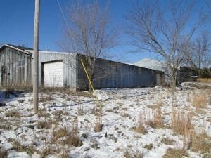
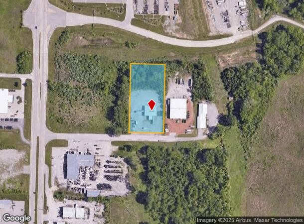
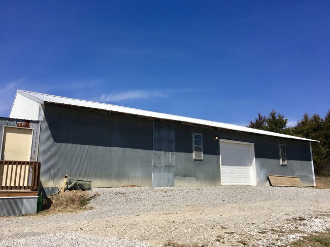
1275 E Harvester Rd
12-417-19-00-007-00-01
PT SW SW (SUR 400-843)
Truckterminal
Boone
X
Missouri
29019C0165D
2 AC
2025
Columbia/Jefferson City
2025
Other Market Areas
001508
Columbia, MO
4,028 SF
DEMOGRAPHICS near 1275 E Harvester Rd
1 Mile
3 Mile
5 Mile
2024 Total Population
5,018
26,368
81,832
2029 Population
5,364
28,076
86,732
Pop Growth 2024-2029
+ 6.90%
+ 6.48%
+ 5.99%
Average Age
35
37
35
2024 Total Households
1,755
10,379
32,630
HH Growth 2024-2029
+ 7.07%
+ 6.66%
+ 6.49%
Median Household Inc
$66,185
$69,442
$49,327
Avg Household Size
2.60
2.40
2.20
2024 Avg HH Vehicles
2.00
2.00
2.00
Median Home Value
$171,936
$180,106
$178,683
Median Year Built
1999
1997
1987
Nearby Places
- Restaurants
- Banks
- Shops
- Fitness
- Groceries
PUBLIC TRANSPORTATION
AIRPORT
Columbia Regional
DRIVE
WALK
Distance
Columbia Regional
23 min
17.7 mi
Freight Ports
Tulsa Port of Inola
DRIVE
WALK
Distance
Tulsa Port of Inola
384 min
340.3 mi
SALE & LEASE HISTORY
LISTING DATE
SALE/LEASE

Apr 24, 2023
For Lease
Apr 24, 2018
For Sale
Nearby Properties
Address
Land Use
TOTAL SIZE
Lot Size
Zoning
Address
Land Use
TOTAL SIZE
Lot Size
Zoning
321,295 SF
79.83 AC
Address
Land Use
TOTAL SIZE
Lot Size
Zoning
134,760 SF
103.42 AC
Address
Land Use
TOTAL SIZE
Lot Size
Zoning
101,072 SF
Address
Land Use
TOTAL SIZE
Lot Size
Zoning
184,413 SF
17.63 AC
CP
Address
Land Use
TOTAL SIZE
Lot Size
Zoning
259,538 SF
26.78 AC
M1
Address
Land Use
TOTAL SIZE
Lot Size
Zoning
56,305 SF
12 AC
CP
Address
Land Use
TOTAL SIZE
Lot Size
Zoning
151,550 SF
53.69 AC
MC
Address
Land Use
TOTAL SIZE
Lot Size
Zoning
83,100 SF
14.96 AC
CP
Address
Land Use
TOTAL SIZE
Lot Size
Zoning
83,978 SF
8.60 AC
C3
Address
Land Use
TOTAL SIZE
Lot Size
Zoning
167,255 SF
14.14 AC
Address
Land Use
TOTAL SIZE
Lot Size
Zoning
63,121 SF
11.28 AC
Address
Land Use
TOTAL SIZE
Lot Size
Zoning
41,600 SF
5.42 AC
Address
Land Use
TOTAL SIZE
Lot Size
Zoning
5,200 SF
11 AC
M1
Address
Land Use
TOTAL SIZE
Lot Size
Zoning
88,738 SF
3.55 AC
CP
Address
Land Use
TOTAL SIZE
Lot Size
Zoning
65,759 SF
4.90 AC
MC
Address
Land Use
TOTAL SIZE
Lot Size
Zoning
51,224 SF
7.42 AC
C1
Address
Land Use
TOTAL SIZE
Lot Size
Zoning
63,165 SF
6.53 AC
M1
Address
Land Use
TOTAL SIZE
Lot Size
Zoning
60,000 SF
6.91 AC
Address
Land Use
TOTAL SIZE
Lot Size
Zoning
36,410 SF
4.40 AC
C3
Address
Land Use
TOTAL SIZE
Lot Size
Zoning
3,078 SF
9.41 AC
R4
Address
Land Use
TOTAL SIZE
Lot Size
Zoning
172,056 SF
31.81 AC
MC
Address
Land Use
TOTAL SIZE
Lot Size
Zoning
100,322 SF
5.67 AC
ML
Address
Land Use
TOTAL SIZE
Lot Size
Zoning
87,408 SF
13.26 AC
Address
Land Use
TOTAL SIZE
Lot Size
Zoning
31,329 SF
8.24 AC
MC
Address
Land Use
TOTAL SIZE
Lot Size
Zoning
58,200 SF
14.68 AC
MC
Address
Land Use
TOTAL SIZE
Lot Size
Zoning
21,120 SF
7.71 AC
Address
Land Use
TOTAL SIZE
Lot Size
Zoning
80,256 SF
10.10 AC
M1
Address
Land Use
TOTAL SIZE
Lot Size
Zoning
72,703 SF
19.99 AC
CP
Address
Land Use
TOTAL SIZE
Lot Size
Zoning
12,052 SF
12.22 AC
C3
Address
Land Use
TOTAL SIZE
Lot Size
Zoning
26,831 SF
5.76 AC
C3
The World's #1 Commercial Real Estate Marketplace
Connect with us
© 2025 CoStar Group
The information above has been obtained from sources believed reliable. While we do not doubt its accuracy we have not verified it and make no guarantee, warranty or representation about it. It is your responsibility to independently confirm its accuracy and completeness. Any projections, opinions, assumptions, or estimates used are for example only and do not represent the current or future performance of the property. The value of this transaction to you depends on tax and other factors which should be evaluated by your tax, financial, and legal advisors. You and your advisors should conduct a careful, independent investigation of the property to determine to your satisfaction the suitability of the property for your needs.