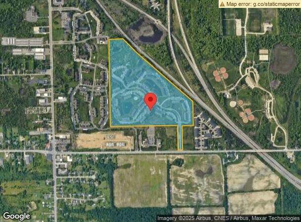
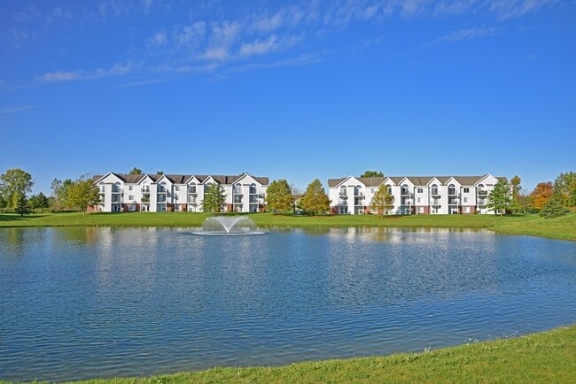
Property Record
1275 Heatherwood Dr, Grand Blanc, MI 48439

NEARBY LISTINGS FOR SALE OR LEASE
-
-
View all Grand Blanc listings for sale on LoopNet.com
Property Detail
1275 Heatherwood Dr
12-18-300-025
A PARCEL OF LAND BEG S 88 DEG 56 MIN 04 SEC E 231.85 FT & N 0 DEG 31 MIN 43 SEC E 50 FT FROM S 1/4 COR OF SEC TH N 0 DEG 31
Commercialnec
Genesee
X
Michigan
26049C0316D
63.88 AC
2024
Grand Blanc/Goodrich
2025
Detroit
011102
Flint, MI
331,630 SF
DEMOGRAPHICS near 1275 Heatherwood Dr
1 Mile
3 Mile
5 Mile
2024 Total Population
3,752
26,790
73,702
2029 Population
3,641
26,128
71,947
Pop Growth 2024-2029
(2.96%)
(2.47%)
(2.38%)
Average Age
40
40
40
2024 Total Households
1,990
11,487
30,682
HH Growth 2024-2029
(3.02%)
(2.61%)
(2.45%)
Median Household Inc
$56,804
$62,271
$58,106
Avg Household Size
1.90
2.30
2.30
2024 Avg HH Vehicles
2.00
2.00
2.00
Median Home Value
$194,299
$189,365
$173,034
Median Year Built
1992
1978
1972
Nearby Places
Map Layers
Map Styles
 Street
 Aerial
- Restaurants
- Banks
- Shops
- Fitness
- Groceries
PUBLIC TRANSPORTATION
COMMUTER RAIL
Flint Amtrak Station (Blue Water - Amtrak)
DRIVE
WALK
Distance
Flint Amtrak Station (Blue Water - Amtrak)
17 min
9.0 mi
AIRPORT
Bishop International
DRIVE
WALK
Distance
Bishop International
22 min
8.0 mi
Freight Ports
Port of Toledo
DRIVE
WALK
Distance
Port of Toledo
131 min
108.3 mi
Nearby Properties
Address
Land Use
TOTAL SIZE
Lot Size
Zoning
Address
Land Use
TOTAL SIZE
Lot Size
Zoning
55,378 SF
23 AC
PO
Address
Land Use
TOTAL SIZE
Lot Size
Zoning
51.26 AC
HDM
Address
Land Use
TOTAL SIZE
Lot Size
Zoning
155,220 SF
33.46 AC
GC
Address
Land Use
TOTAL SIZE
Lot Size
Zoning
295,620 SF
25.62 AC
MDM
Address
Land Use
TOTAL SIZE
Lot Size
Zoning
33.65 AC
MDM
Address
Land Use
TOTAL SIZE
Lot Size
Zoning
86,286 SF
71.83 AC
HCD
Address
Land Use
TOTAL SIZE
Lot Size
Zoning
147,756 SF
59.86 AC
R2
Address
Land Use
TOTAL SIZE
Lot Size
Zoning
210,684 SF
27.06 AC
GC
Address
Land Use
TOTAL SIZE
Lot Size
Zoning
173,074 SF
10 AC
MDM
Address
Land Use
TOTAL SIZE
Lot Size
Zoning
120,487 SF
5.81 AC
PRC
Address
Land Use
TOTAL SIZE
Lot Size
Zoning
223,683 SF
24.88 AC
MDM
Address
Land Use
TOTAL SIZE
Lot Size
Zoning
612,305 SF
116.49 AC
I-2
Address
Land Use
TOTAL SIZE
Lot Size
Zoning
78,517 SF
16.80 AC
GC
Address
Land Use
TOTAL SIZE
Lot Size
Zoning
674,049 SF
24.02 AC
I-2
Address
Land Use
TOTAL SIZE
Lot Size
Zoning
141,748 SF
8.80 AC
MDM
Address
Land Use
TOTAL SIZE
Lot Size
Zoning
315,700 SF
38.97 AC
RM-2
Address
Land Use
TOTAL SIZE
Lot Size
Zoning
64,897 SF
1.86 AC
GC
Address
Land Use
TOTAL SIZE
Lot Size
Zoning
65,746 SF
3.97 AC
C-4
Address
Land Use
TOTAL SIZE
Lot Size
Zoning
45,204 SF
6.43 AC
M-M
Address
Land Use
TOTAL SIZE
Lot Size
Zoning
104,040 SF
17.02 AC
MDM
Address
Land Use
TOTAL SIZE
Lot Size
Zoning
36,638 SF
10.01 AC
GC
Address
Land Use
TOTAL SIZE
Lot Size
Zoning
88,701 SF
10.27 AC
GC
Address
Land Use
TOTAL SIZE
Lot Size
Zoning
75,536 SF
8.97 AC
PRC
Address
Land Use
TOTAL SIZE
Lot Size
Zoning
137,169 SF
18.50 AC
GC
Address
Land Use
TOTAL SIZE
Lot Size
Zoning
210.33 AC
MHP
Address
Land Use
TOTAL SIZE
Lot Size
Zoning
51,625 SF
6 AC
HCD
Address
Land Use
TOTAL SIZE
Lot Size
Zoning
69,232 SF
2.75 AC
C-3A
Address
Land Use
TOTAL SIZE
Lot Size
Zoning
131,682 SF
11.51 AC
MDM
Address
Land Use
TOTAL SIZE
Lot Size
Zoning
15.19 AC
M-M
The World's #1 Commercial Real Estate Marketplace
Connect with us
© 2026 CoStar Group
The information above has been obtained from sources believed reliable. While we do not doubt its accuracy we have not verified it and make no guarantee, warranty or representation about it. It is your responsibility to independently confirm its accuracy and completeness. Any projections, opinions, assumptions, or estimates used are for example only and do not represent the current or future performance of the property. The value of this transaction to you depends on tax and other factors which should be evaluated by your tax, financial, and legal advisors. You and your advisors should conduct a careful, independent investigation of the property to determine to your satisfaction the suitability of the property for your needs.