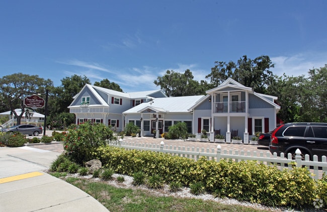
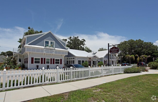
Property Record
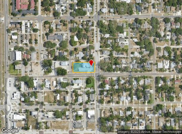
1275 Nebraska Ave, Palm Harbor, FL 34683
NEARBY LISTINGS FOR SALE OR LEASE
Property Detail
1275 Nebraska Ave
Tampa-St. Petersburg-Clearwater, FL
Sutherland, Town Of
01-28-15-88560-068-1800
SUTHERLAND, TOWN OF BLK 68, LOTS 11 THRU 20 (SEE N02-28-15)
Officebuilding
Pinellas
X
Florida
12103C0059H
11-20
2024
0.66 AC
2025
North Pinellas
027206
Tampa/St Petersburg
8,468 SF
DEMOGRAPHICS near 1275 Nebraska Ave
1 Mile
3 Mile
5 Mile
2024 Total Population
8,308
59,599
145,833
2029 Population
8,092
59,016
145,484
Pop Growth 2024-2029
(2.60%)
(0.98%)
(0.24%)
Average Age
44
49
49
2024 Total Households
3,308
26,737
67,542
HH Growth 2024-2029
(3.08%)
(1.04%)
(0.34%)
Median Household Inc
$86,946
$69,178
$64,093
Avg Household Size
2.40
2.10
2.10
2024 Avg HH Vehicles
2.00
2.00
2.00
Median Home Value
$372,949
$346,524
$316,513
Median Year Built
1982
1983
1982
Nearby Places
Map Layers
Map Styles
 Street
 Aerial
- Restaurants
- Banks
- Shops
- Fitness
- Groceries
PUBLIC TRANSPORTATION
AIRPORT
St Pete-Clearwater International
DRIVE
WALK
Distance
St Pete-Clearwater International
25 min
15.7 mi
Tampa International
DRIVE
WALK
Distance
Tampa International
35 min
19.4 mi
Freight Ports
Port of Tampa Bay
DRIVE
WALK
Distance
Port of Tampa Bay
49 min
27.9 mi
Nearby Properties
Address
Land Use
TOTAL SIZE
Lot Size
Zoning
Address
Land Use
TOTAL SIZE
Lot Size
Zoning
535,063 SF
34.58 AC
RPD5
Address
Land Use
TOTAL SIZE
Lot Size
Zoning
270,606 SF
53.27 AC
AE
Address
Land Use
TOTAL SIZE
Lot Size
Zoning
242,708 SF
26.17 AC
RPD10
Address
Land Use
TOTAL SIZE
Lot Size
Zoning
208,427 SF
12.11 AC
Address
Land Use
TOTAL SIZE
Lot Size
Zoning
239,480 SF
18.89 AC
RPD5
Address
Land Use
TOTAL SIZE
Lot Size
Zoning
188,845 SF
33.69 AC
RPD5
Address
Land Use
TOTAL SIZE
Lot Size
Zoning
117,024 SF
56.52 AC
Address
Land Use
TOTAL SIZE
Lot Size
Zoning
161,404 SF
18.48 AC
CP2
Address
Land Use
TOTAL SIZE
Lot Size
Zoning
199,825 SF
22.75 AC
R2
Address
Land Use
TOTAL SIZE
Lot Size
Zoning
151,398 SF
15.55 AC
CP1
Address
Land Use
TOTAL SIZE
Lot Size
Zoning
311,414 SF
15.59 AC
RPD75
Address
Land Use
TOTAL SIZE
Lot Size
Zoning
116,975 SF
9 AC
AE
Address
Land Use
TOTAL SIZE
Lot Size
Zoning
137,649 SF
8.08 AC
Address
Land Use
TOTAL SIZE
Lot Size
Zoning
173,160 SF
5.39 AC
Address
Land Use
TOTAL SIZE
Lot Size
Zoning
273,134 SF
1.44 AC
RPD5
Address
Land Use
TOTAL SIZE
Lot Size
Zoning
446,974 SF
11.32 AC
AE
Address
Land Use
TOTAL SIZE
Lot Size
Zoning
94,029 SF
19.67 AC
RPD75
Address
Land Use
TOTAL SIZE
Lot Size
Zoning
92,511 SF
18.39 AC
RPD75
Address
Land Use
TOTAL SIZE
Lot Size
Zoning
99,361 SF
12.64 AC
CP1
Address
Land Use
TOTAL SIZE
Lot Size
Zoning
92,817 SF
6.42 AC
PC
Address
Land Use
TOTAL SIZE
Lot Size
Zoning
112,719 SF
9.36 AC
CP1
Address
Land Use
TOTAL SIZE
Lot Size
Zoning
36,668 SF
65.18 AC
AE
Address
Land Use
TOTAL SIZE
Lot Size
Zoning
93,413 SF
12.35 AC
RPD10
Address
Land Use
TOTAL SIZE
Lot Size
Zoning
93,840 SF
8.66 AC
CP1
Address
Land Use
TOTAL SIZE
Lot Size
Zoning
105,830 SF
10.84 AC
CP2
Address
Land Use
TOTAL SIZE
Lot Size
Zoning
117,262 SF
15.32 AC
CP1
Address
Land Use
TOTAL SIZE
Lot Size
Zoning
65,929 SF
5.96 AC
C2
Address
Land Use
TOTAL SIZE
Lot Size
Zoning
97,776 SF
9.63 AC
Address
Land Use
TOTAL SIZE
Lot Size
Zoning
103,393 SF
17.68 AC
R4
Address
Land Use
TOTAL SIZE
Lot Size
Zoning
101,243 SF
5.36 AC
M1
The World's #1 Commercial Real Estate Marketplace
Connect with us
© 2025 CoStar Group
The information above has been obtained from sources believed reliable. While we do not doubt its accuracy we have not verified it and make no guarantee, warranty or representation about it. It is your responsibility to independently confirm its accuracy and completeness. Any projections, opinions, assumptions, or estimates used are for example only and do not represent the current or future performance of the property. The value of this transaction to you depends on tax and other factors which should be evaluated by your tax, financial, and legal advisors. You and your advisors should conduct a careful, independent investigation of the property to determine to your satisfaction the suitability of the property for your needs.