Property Record
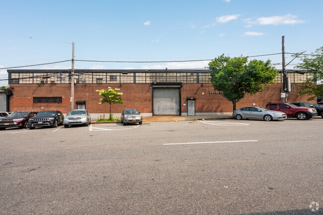
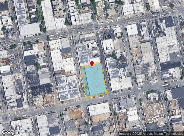
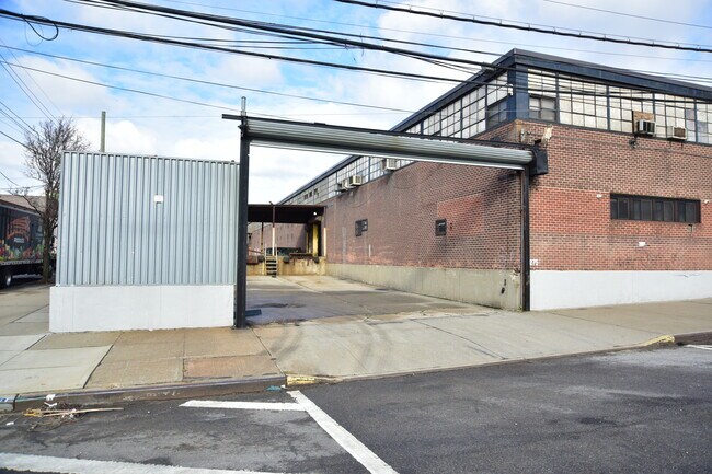
1265 Oakpoint Ave, Bronx, NY 10474

Current Lease Availabilities
NEARBY LISTINGS FOR SALE OR LEASE
Property Detail
1265 Oakpoint Ave
02768-0305
Bronx
Warehouse
New York
X
305
3604970092F
1.38 AC
2024
Bronx
2025
Westchester/So Connecticut
009301
New York-Jersey City-White Plains, NY-NJ
50,000 SF
DEMOGRAPHICS near 1265 Oakpoint Ave
1 mile
3 mile
5 mile
2024 Total Population
51,910
833,291
2,634,480
2029 Population
48,314
772,289
2,444,864
Pop Growth 2024-2029
(6.93%)
(7.32%)
(7.20%)
Average Age
37
37
40
2024 Total Households
17,798
297,862
1,002,644
HH Growth 2024-2029
(7.78%)
(7.96%)
(7.62%)
Median Household Inc
$37,288
$38,701
$54,714
Avg Household Size
2.70
2.60
2.50
2024 Avg HH Vehicles
.00
.00
.00
Median Home Value
$385,199
$574,583
$709,309
Median Year Built
1962
1957
1952
Nearby Places
Map Layers
Map Styles
 Street
 Aerial
Transit
 Traffic
 Biking
Places
Listings with unknown addresses are not visible on the map
- Restaurants
- Banks
- Shops
- Fitness
- Groceries
PUBLIC TRANSPORTATION
TRANSIT/SUBWAY
Longwood Avenue (6 - New York MTA Subway (The Subway))
Drive
Walk
Distance
Longwood Avenue (6 - New York MTA Subway (The Subway))
1 min
13 min
0.7 mi
Hunts Point Avenue (6 - New York MTA Subway (The Subway))
Drive
Walk
Distance
Hunts Point Avenue (6 - New York MTA Subway (The Subway))
2 min
14 min
0.7 mi
East 149 Street (6 - New York MTA Subway (The Subway))
Drive
Walk
Distance
East 149 Street (6 - New York MTA Subway (The Subway))
2 min
19 min
1.0 mi
Simpson Street (2 - New York MTA Subway (The Subway), 5 - New York MTA Subway (The Subway))
Drive
Walk
Distance
Simpson Street (2 - New York MTA Subway (The Subway), 5 - New York MTA Subway (The Subway))
3 min
20 min
1.1 mi
COMMUTER RAIL
Melrose Station (Harlem Line - Metro-North Commuter Railroad Company (Metro-North))
Drive
Walk
Distance
Melrose Station (Harlem Line - Metro-North Commuter Railroad Company (Metro-North))
7 min
2.4 mi
Yankees-E 153Rd Street Station (Hudson Line - Metro-North Commuter Railroad Company (Metro-North))
Drive
Walk
Distance
Yankees-E 153Rd Street Station (Hudson Line - Metro-North Commuter Railroad Company (Metro-North))
6 min
3.9 mi
AIRPORT
LaGuardia
Drive
Walk
Distance
LaGuardia
15 min
7.3 mi
John F Kennedy International
Drive
Walk
Distance
John F Kennedy International
28 min
18.5 mi
Newark Liberty International
Drive
Walk
Distance
Newark Liberty International
32 min
25.7 mi
Freight Ports
NY - Red Hook Container Terminal
Drive
Walk
Distance
NY - Red Hook Container Terminal
27 min
15.4 mi
Nearby Properties
Address
Land Use
TOTAL SIZE
Lot Size
Zoning
Address
Land Use
TOTAL SIZE
Lot Size
Zoning
5,519,372 SF
409.21 AC
C8-2
Address
Land Use
TOTAL SIZE
Lot Size
Zoning
2,278,432 SF
5.99 AC
R7-2
Address
Land Use
TOTAL SIZE
Lot Size
Zoning
11.92 AC
R7-2
Address
Land Use
TOTAL SIZE
Lot Size
Zoning
11.92 AC
R7-2
Address
Land Use
TOTAL SIZE
Lot Size
Zoning
11.92 AC
R7-2
Address
Land Use
TOTAL SIZE
Lot Size
Zoning
11.92 AC
R7-2
Address
Land Use
TOTAL SIZE
Lot Size
Zoning
11.92 AC
R7-2
Address
Land Use
TOTAL SIZE
Lot Size
Zoning
11.92 AC
R7-2
Address
Land Use
TOTAL SIZE
Lot Size
Zoning
11.92 AC
R7-2
Address
Land Use
TOTAL SIZE
Lot Size
Zoning
11.92 AC
R7-2
Address
Land Use
TOTAL SIZE
Lot Size
Zoning
11.92 AC
R7-2
Address
Land Use
TOTAL SIZE
Lot Size
Zoning
11.92 AC
R7-2
Address
Land Use
TOTAL SIZE
Lot Size
Zoning
11.92 AC
R7-2
Address
Land Use
TOTAL SIZE
Lot Size
Zoning
11.92 AC
R7-2
Address
Land Use
TOTAL SIZE
Lot Size
Zoning
11.92 AC
R7-2
Address
Land Use
TOTAL SIZE
Lot Size
Zoning
11.92 AC
R7-2
Address
Land Use
TOTAL SIZE
Lot Size
Zoning
11.92 AC
R7-2
Address
Land Use
TOTAL SIZE
Lot Size
Zoning
11.92 AC
R7-2
Address
Land Use
TOTAL SIZE
Lot Size
Zoning
11.92 AC
R7-2
Address
Land Use
TOTAL SIZE
Lot Size
Zoning
11.92 AC
R7-2
Address
Land Use
TOTAL SIZE
Lot Size
Zoning
11.92 AC
R7-2
Address
Land Use
TOTAL SIZE
Lot Size
Zoning
11.92 AC
R7-2
Address
Land Use
TOTAL SIZE
Lot Size
Zoning
11.92 AC
R7-2
Address
Land Use
TOTAL SIZE
Lot Size
Zoning
11.92 AC
R7-2
Address
Land Use
TOTAL SIZE
Lot Size
Zoning
11.92 AC
R7-2
Address
Land Use
TOTAL SIZE
Lot Size
Zoning
11.92 AC
R7-2
Address
Land Use
TOTAL SIZE
Lot Size
Zoning
11.92 AC
R7-2
Address
Land Use
TOTAL SIZE
Lot Size
Zoning
11.92 AC
R7-2
Address
Land Use
TOTAL SIZE
Lot Size
Zoning
11.92 AC
R7-2
Address
Land Use
TOTAL SIZE
Lot Size
Zoning
11.92 AC
R7-2
The World's #1 Commercial Real Estate Marketplace
Connect with us
© 2026 CoStar Group
The information above has been obtained from sources believed reliable. While we do not doubt its accuracy we have not verified it and make no guarantee, warranty or representation about it. It is your responsibility to independently confirm its accuracy and completeness. Any projections, opinions, assumptions, or estimates used are for example only and do not represent the current or future performance of the property. The value of this transaction to you depends on tax and other factors which should be evaluated by your tax, financial, and legal advisors. You and your advisors should conduct a careful, independent investigation of the property to determine to your satisfaction the suitability of the property for your needs.