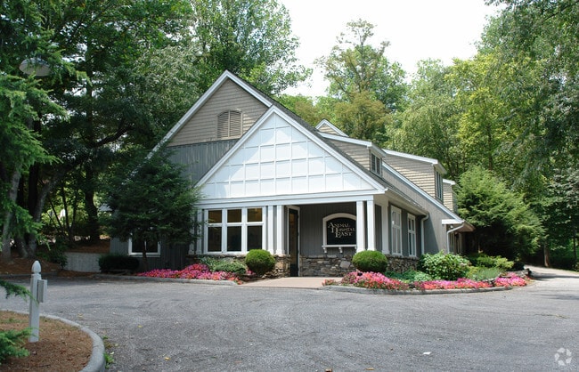
Property Record
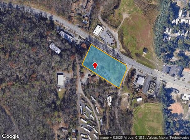
1275 Tunnel Rd, Asheville, NC 28805
This Property Is For Sale
NEARBY LISTINGS FOR SALE OR LEASE
Property Detail
1275 Tunnel Rd
9668-75-5822-00000
SUBDIV: BLOCK: LOT: SECTION: PLAT: 0000-0000
Animalhospitalvet
Buncombe
X
North Carolina
3700966800J
2.36 AC
0
East Asheville
2025
Asheville
003003
Asheville, NC
3,313 SF
DEMOGRAPHICS near 1275 Tunnel Rd
1 Mile
3 Mile
5 Mile
2024 Total Population
3,090
25,017
64,371
2029 Population
3,157
25,917
66,936
Pop Growth 2024-2029
+ 2.17%
+ 3.60%
+ 3.98%
Average Age
46
45
44
2024 Total Households
1,463
11,480
29,764
HH Growth 2024-2029
+ 1.57%
+ 3.02%
+ 3.51%
Median Household Inc
$57,642
$63,744
$63,326
Avg Household Size
2.00
2.10
2.10
2024 Avg HH Vehicles
2.00
2.00
2.00
Median Home Value
$264,207
$322,142
$348,000
Median Year Built
1981
1986
1983
Nearby Places
Map Layers
Map Styles
 Street
 Aerial
- Restaurants
- Banks
- Shops
- Fitness
- Groceries
PUBLIC TRANSPORTATION
AIRPORT
Asheville Regional
DRIVE
WALK
Distance
Asheville Regional
24 min
14.1 mi
Nearby Properties
Address
Land Use
TOTAL SIZE
Lot Size
Zoning
Address
Land Use
TOTAL SIZE
Lot Size
Zoning
316,968 SF
102.56 AC
PS
Address
Land Use
TOTAL SIZE
Lot Size
Zoning
323,429 SF
1,005.50 AC
PS
Address
Land Use
TOTAL SIZE
Lot Size
Zoning
426,688 SF
40.88 AC
UP
Address
Land Use
TOTAL SIZE
Lot Size
Zoning
93,321 SF
30.95 AC
NS
Address
Land Use
TOTAL SIZE
Lot Size
Zoning
79,701 SF
15.26 AC
RM16
Address
Land Use
TOTAL SIZE
Lot Size
Zoning
74,409 SF
22.20 AC
NS
Address
Land Use
TOTAL SIZE
Lot Size
Zoning
45.86 AC
INST
Address
Land Use
TOTAL SIZE
Lot Size
Zoning
100,643 SF
15.06 AC
INST
Address
Land Use
TOTAL SIZE
Lot Size
Zoning
130,636 SF
13.19 AC
UP
Address
Land Use
TOTAL SIZE
Lot Size
Zoning
90,832 SF
1,103.09 AC
CR
Address
Land Use
TOTAL SIZE
Lot Size
Zoning
153,820 SF
13.79 AC
UP
Address
Land Use
TOTAL SIZE
Lot Size
Zoning
47,416 SF
7 AC
RS8
Address
Land Use
TOTAL SIZE
Lot Size
Zoning
75,979 SF
10.40 AC
R-3
Address
Land Use
TOTAL SIZE
Lot Size
Zoning
141,911 SF
51.27 AC
RM16
Address
Land Use
TOTAL SIZE
Lot Size
Zoning
118,407 SF
11 AC
UP
Address
Land Use
TOTAL SIZE
Lot Size
Zoning
220,408 SF
21.03 AC
UP
Address
Land Use
TOTAL SIZE
Lot Size
Zoning
100,124 SF
50.50 AC
RIVER
Address
Land Use
TOTAL SIZE
Lot Size
Zoning
70,025 SF
22.85 AC
RS4
Address
Land Use
TOTAL SIZE
Lot Size
Zoning
41,751 SF
10.05 AC
RS4
Address
Land Use
TOTAL SIZE
Lot Size
Zoning
14,056 SF
3.49 AC
HB
Address
Land Use
TOTAL SIZE
Lot Size
Zoning
40,735 SF
4.67 AC
UP
Address
Land Use
TOTAL SIZE
Lot Size
Zoning
24,136 SF
6.07 AC
HB
Address
Land Use
TOTAL SIZE
Lot Size
Zoning
66,858 SF
10.24 AC
RM16
Address
Land Use
TOTAL SIZE
Lot Size
Zoning
115,530 SF
15.06 AC
RIVER
Address
Land Use
TOTAL SIZE
Lot Size
Zoning
119,054 SF
12.06 AC
CI
Address
Land Use
TOTAL SIZE
Lot Size
Zoning
68,662 SF
7.58 AC
RM16
Address
Land Use
TOTAL SIZE
Lot Size
Zoning
52,382 SF
12.50 AC
INST
Address
Land Use
TOTAL SIZE
Lot Size
Zoning
32,620 SF
2.76 AC
CBI
Address
Land Use
TOTAL SIZE
Lot Size
Zoning
134,900 SF
15.58 AC
RB
Address
Land Use
TOTAL SIZE
Lot Size
Zoning
125,482 SF
12.07 AC
CI
The World's #1 Commercial Real Estate Marketplace
Connect with us
© 2026 CoStar Group
The information above has been obtained from sources believed reliable. While we do not doubt its accuracy we have not verified it and make no guarantee, warranty or representation about it. It is your responsibility to independently confirm its accuracy and completeness. Any projections, opinions, assumptions, or estimates used are for example only and do not represent the current or future performance of the property. The value of this transaction to you depends on tax and other factors which should be evaluated by your tax, financial, and legal advisors. You and your advisors should conduct a careful, independent investigation of the property to determine to your satisfaction the suitability of the property for your needs.