Property Record
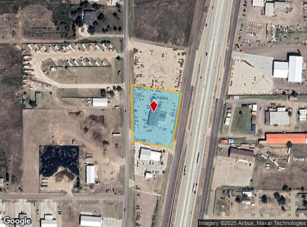
12760 Interstate 27, Amarillo, TX 79119
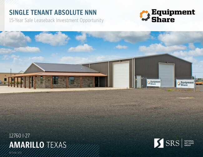

Property Detail
12760 Interstate 27
Amarillo, TX
Mathes Acres # 4
R-044-8590-0510
MATHES ACRES # 4, LOT 23B, 2.3400 ACRES
Warehouse
Randall
X
Texas
48381C0210E
23b
2024
2.34 AC
2025
Amarillo
021707
Other Market Areas
9,020 SF
NEARBY LISTINGS FOR SALE OR LEASE
DEMOGRAPHICS near 12760 Interstate 27
1 mile
3 mile
5 mile
2024 Total Population
1,632
10,705
46,390
2029 Population
1,820
11,938
51,209
Pop Growth 2024-2029
+ 11.52%
+ 11.52%
+ 10.39%
Average Age
37
38
39
2024 Total Households
590
3,800
17,588
HH Growth 2024-2029
+ 11.69%
+ 11.68%
+ 10.46%
Median Household Inc
$74,186
$81,807
$89,076
Avg Household Size
2.80
2.70
2.60
2024 Avg HH Vehicles
2.00
2.00
2.00
Median Home Value
$164,795
$247,314
$239,467
Median Year Built
2000
2000
2001
Nearby Places
Map Layers
Map Styles
 Street
 Aerial
Transit
 Traffic
 Biking
Places
Listings with unknown addresses are not visible on the map
- Restaurants
- Banks
- Shops
- Fitness
- Groceries
PUBLIC TRANSPORTATION
AIRPORT
Rick Husband Amarillo International
Drive
Walk
Distance
Rick Husband Amarillo International
28 min
19.5 mi
Freight Ports
Tulsa Port Of Catoosa
Drive
Walk
Distance
Tulsa Port Of Catoosa
410 min
387.5 mi
SALE & LEASE HISTORY
LISTING DATE
SALE/LEASE

Nov 05, 2021
For Sale
Jun 20, 2023
For Sale
Jan 17, 2024
For Sale
Feb 08, 2022
For Sale
Aug 18, 2021
For Sale
Aug 09, 2024
For Sale
Nearby Properties
Address
Land Use
TOTAL SIZE
Lot Size
Zoning
Address
Land Use
TOTAL SIZE
Lot Size
Zoning
258,757 SF
22.78 AC
A
Address
Land Use
TOTAL SIZE
Lot Size
Zoning
148,486 SF
20.66 AC
Address
Land Use
TOTAL SIZE
Lot Size
Zoning
190,074 SF
12.07 AC
Address
Land Use
TOTAL SIZE
Lot Size
Zoning
161,321 SF
31 AC
A
Address
Land Use
TOTAL SIZE
Lot Size
Zoning
84,200 SF
7.99 AC
Address
Land Use
TOTAL SIZE
Lot Size
Zoning
42,306 SF
8 AC
Address
Land Use
TOTAL SIZE
Lot Size
Zoning
243,210 SF
20.11 AC
Address
Land Use
TOTAL SIZE
Lot Size
Zoning
56,248 SF
39.09 AC
Address
Land Use
TOTAL SIZE
Lot Size
Zoning
59,625 SF
12 AC
Address
Land Use
TOTAL SIZE
Lot Size
Zoning
266,593 SF
26.42 AC
Address
Land Use
TOTAL SIZE
Lot Size
Zoning
74,809 SF
12.56 AC
LC
Address
Land Use
TOTAL SIZE
Lot Size
Zoning
27,005 SF
14.67 AC
Address
Land Use
TOTAL SIZE
Lot Size
Zoning
49,025 SF
4.37 AC
Address
Land Use
TOTAL SIZE
Lot Size
Zoning
42,349 SF
1.72 AC
LC
Address
Land Use
TOTAL SIZE
Lot Size
Zoning
42,597 SF
1.94 AC
LC
Address
Land Use
TOTAL SIZE
Lot Size
Zoning
16,195 SF
4.50 AC
Address
Land Use
TOTAL SIZE
Lot Size
Zoning
44,591 SF
4.24 AC
Address
Land Use
TOTAL SIZE
Lot Size
Zoning
10,968 SF
23.54 AC
Address
Land Use
TOTAL SIZE
Lot Size
Zoning
24,375 SF
6.01 AC
Address
Land Use
TOTAL SIZE
Lot Size
Zoning
25,560 SF
10.02 AC
Address
Land Use
TOTAL SIZE
Lot Size
Zoning
900 SF
13.39 AC
A
Address
Land Use
TOTAL SIZE
Lot Size
Zoning
11,013 SF
4.93 AC
Address
Land Use
TOTAL SIZE
Lot Size
Zoning
22,340 SF
3.07 AC
Address
Land Use
TOTAL SIZE
Lot Size
Zoning
19,040 SF
5.09 AC
Address
Land Use
TOTAL SIZE
Lot Size
Zoning
76,466 SF
2.98 AC
Address
Land Use
TOTAL SIZE
Lot Size
Zoning
29,900 SF
10.01 AC
Address
Land Use
TOTAL SIZE
Lot Size
Zoning
61,004 SF
12.88 AC
Address
Land Use
TOTAL SIZE
Lot Size
Zoning
22,500 SF
6 AC
Address
Land Use
TOTAL SIZE
Lot Size
Zoning
9,750 SF
3.19 AC
Address
Land Use
TOTAL SIZE
Lot Size
Zoning
4,719 SF
1.37 AC
The World's #1 Commercial Real Estate Marketplace
Connect with us
© 2026 CoStar Group
The information above has been obtained from sources believed reliable. While we do not doubt its accuracy we have not verified it and make no guarantee, warranty or representation about it. It is your responsibility to independently confirm its accuracy and completeness. Any projections, opinions, assumptions, or estimates used are for example only and do not represent the current or future performance of the property. The value of this transaction to you depends on tax and other factors which should be evaluated by your tax, financial, and legal advisors. You and your advisors should conduct a careful, independent investigation of the property to determine to your satisfaction the suitability of the property for your needs.