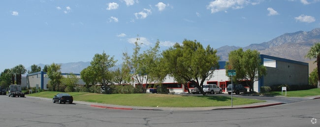
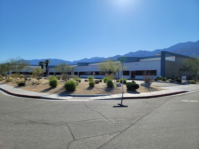
Property Record
1277 N Valdivia Way, Palm Springs, CA 92262


NEARBY LISTINGS FOR SALE OR LEASE
Property Detail
1277 N Valdivia Way
Riverside-San Bernardino-Ontario, CA
Tract No. 12182
677-462-005
2.14 ACRES M/L IN LOTS 1 & 2 MB 100/009 TR 12182
Warehouse
Riverside
X
California
06065C1559G
2
2024
2.14 AC
2025
Coachella Valley
044602
Inland Empire (California)
33,704 SF
DEMOGRAPHICS near 1277 N Valdivia Way
1 Mile
3 Mile
5 Mile
2024 Total Population
3,429
74,208
122,601
2029 Population
3,760
81,168
134,253
Pop Growth 2024-2029
+ 9.65%
+ 9.38%
+ 9.50%
Average Age
52
47
47
2024 Total Households
1,672
33,291
55,299
HH Growth 2024-2029
+ 9.45%
+ 9.66%
+ 9.92%
Median Household Inc
$85,124
$70,235
$65,798
Avg Household Size
2.00
2.10
2.10
2024 Avg HH Vehicles
2.00
2.00
2.00
Median Home Value
$703,736
$611,722
$596,494
Median Year Built
1980
1982
1983
Nearby Places
Map Layers
Map Styles
 Street
 Aerial
- Restaurants
- Banks
- Shops
- Fitness
- Groceries
PUBLIC TRANSPORTATION
COMMUTER RAIL
Palm Springs Amtrak (Sunset Limited - Amtrak, Texas Eagle - Amtrak)
DRIVE
WALK
Distance
Palm Springs Amtrak (Sunset Limited - Amtrak, Texas Eagle - Amtrak)
14 min
6.8 mi
AIRPORT
Palm Springs International
DRIVE
WALK
Distance
Palm Springs International
3 min
0.8 mi
Freight Ports
Port of San Diego
DRIVE
WALK
Distance
Port of San Diego
156 min
128.4 mi
SALE & LEASE HISTORY
LISTING DATE
SALE/LEASE

Jun 14, 2017
For Lease
Apr 08, 2025
For Sale
Nearby Properties
Address
Land Use
TOTAL SIZE
Lot Size
Zoning
Address
Land Use
TOTAL SIZE
Lot Size
Zoning
485,000 SF
14.71 AC
Address
Land Use
TOTAL SIZE
Lot Size
Zoning
197,439 SF
8.76 AC
Address
Land Use
TOTAL SIZE
Lot Size
Zoning
258,547 SF
3.84 AC
Address
Land Use
TOTAL SIZE
Lot Size
Zoning
445,755 SF
16.21 AC
R3
Address
Land Use
TOTAL SIZE
Lot Size
Zoning
332,356 SF
9.05 AC
Address
Land Use
TOTAL SIZE
Lot Size
Zoning
35,188 SF
5.98 AC
R3
Address
Land Use
TOTAL SIZE
Lot Size
Zoning
148,746 SF
6.21 AC
R3
Address
Land Use
TOTAL SIZE
Lot Size
Zoning
225,833 SF
22 AC
Address
Land Use
TOTAL SIZE
Lot Size
Zoning
207,931 SF
6.34 AC
C1AA
Address
Land Use
TOTAL SIZE
Lot Size
Zoning
129,852 SF
11.17 AC
Address
Land Use
TOTAL SIZE
Lot Size
Zoning
5,509 SF
10.06 AC
PCC
Address
Land Use
TOTAL SIZE
Lot Size
Zoning
120,754 SF
14.30 AC
Address
Land Use
TOTAL SIZE
Lot Size
Zoning
147,744 SF
3.62 AC
Address
Land Use
TOTAL SIZE
Lot Size
Zoning
120,548 SF
4.63 AC
Address
Land Use
TOTAL SIZE
Lot Size
Zoning
3.20 AC
GR5
Address
Land Use
TOTAL SIZE
Lot Size
Zoning
48,958 SF
0.96 AC
Address
Land Use
TOTAL SIZE
Lot Size
Zoning
70,670 SF
3.90 AC
R4
Address
Land Use
TOTAL SIZE
Lot Size
Zoning
31,488 SF
3.40 AC
A
Address
Land Use
TOTAL SIZE
Lot Size
Zoning
56,129 SF
2.76 AC
R3
Address
Land Use
TOTAL SIZE
Lot Size
Zoning
28,506 SF
2.30 AC
R3
Address
Land Use
TOTAL SIZE
Lot Size
Zoning
233,083 SF
2.20 AC
Address
Land Use
TOTAL SIZE
Lot Size
Zoning
126,869 SF
6.53 AC
Address
Land Use
TOTAL SIZE
Lot Size
Zoning
133,920 SF
8.26 AC
R1
Address
Land Use
TOTAL SIZE
Lot Size
Zoning
114,044 SF
5.40 AC
R3
Address
Land Use
TOTAL SIZE
Lot Size
Zoning
109,231 SF
5.57 AC
R4
Address
Land Use
TOTAL SIZE
Lot Size
Zoning
86,810 SF
3.60 AC
R4VP
Address
Land Use
TOTAL SIZE
Lot Size
Zoning
103,526 SF
11.40 AC
Address
Land Use
TOTAL SIZE
Lot Size
Zoning
238,554 SF
13.31 AC
R1
Address
Land Use
TOTAL SIZE
Lot Size
Zoning
0.51 AC
C-B-D
Address
Land Use
TOTAL SIZE
Lot Size
Zoning
81,687 SF
4.97 AC
R3
The World's #1 Commercial Real Estate Marketplace
Connect with us
© 2026 CoStar Group
The information above has been obtained from sources believed reliable. While we do not doubt its accuracy we have not verified it and make no guarantee, warranty or representation about it. It is your responsibility to independently confirm its accuracy and completeness. Any projections, opinions, assumptions, or estimates used are for example only and do not represent the current or future performance of the property. The value of this transaction to you depends on tax and other factors which should be evaluated by your tax, financial, and legal advisors. You and your advisors should conduct a careful, independent investigation of the property to determine to your satisfaction the suitability of the property for your needs.