Property Record
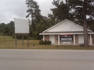
12786 Interstate 45 N, Willis, TX 77378

NEARBY LISTINGS FOR SALE OR LEASE
Property Detail
12786 Interstate 45 N
Houston-The Woodlands-Sugar Land, TX
Bates 01
2520-00-04600
BATES 01, BLOCK 6, LOT 2-A,3
Commercialnec
Montgomery
X
Texas
48339C0240G
2-a
2024
0.23 AC
2025
Outlying Montgomery Cnty
694105
Houston
1,715 SF
DEMOGRAPHICS near 12786 Interstate 45 N
1 Mile
3 Mile
5 Mile
2024 Total Population
4,393
19,593
47,012
2029 Population
5,415
24,215
58,274
Pop Growth 2024-2029
+ 23.26%
+ 23.59%
+ 23.96%
Average Age
35
36
39
2024 Total Households
1,475
6,644
16,925
HH Growth 2024-2029
+ 23.46%
+ 23.78%
+ 24.20%
Median Household Inc
$60,225
$64,422
$70,968
Avg Household Size
3.00
2.90
2.70
2024 Avg HH Vehicles
2.00
2.00
2.00
Median Home Value
$176,086
$201,222
$242,444
Median Year Built
1995
1997
2000
Nearby Places
Map Layers
Map Styles
 Street
 Aerial
- Restaurants
- Banks
- Shops
- Fitness
- Groceries
PUBLIC TRANSPORTATION
AIRPORT
George Bush Intcntl/Houston
DRIVE
WALK
Distance
George Bush Intcntl/Houston
49 min
39.5 mi
Freight Ports
Port of Houston
DRIVE
WALK
Distance
Port of Houston
72 min
55.2 mi
SALE & LEASE HISTORY
LISTING DATE
SALE/LEASE

Dec 27, 2018
For Lease
Dec 27, 2018
For Sale
Nearby Properties
Address
Land Use
TOTAL SIZE
Lot Size
Zoning
Address
Land Use
TOTAL SIZE
Lot Size
Zoning
Address
Land Use
TOTAL SIZE
Lot Size
Zoning
1,583.40 AC
4
Address
Land Use
TOTAL SIZE
Lot Size
Zoning
448,675 SF
52.68 AC
4
Address
Land Use
TOTAL SIZE
Lot Size
Zoning
251,207 SF
45 AC
Address
Land Use
TOTAL SIZE
Lot Size
Zoning
117,918 SF
13.63 AC
Address
Land Use
TOTAL SIZE
Lot Size
Zoning
204,759 SF
31.46 AC
Address
Land Use
TOTAL SIZE
Lot Size
Zoning
265,346 SF
74.32 AC
4
Address
Land Use
TOTAL SIZE
Lot Size
Zoning
73,812 SF
9.51 AC
Address
Land Use
TOTAL SIZE
Lot Size
Zoning
87,983 SF
13.90 AC
Address
Land Use
TOTAL SIZE
Lot Size
Zoning
198,970 SF
10.95 AC
Address
Land Use
TOTAL SIZE
Lot Size
Zoning
34,832 SF
31.27 AC
Address
Land Use
TOTAL SIZE
Lot Size
Zoning
203,735 SF
9.26 AC
4
Address
Land Use
TOTAL SIZE
Lot Size
Zoning
31,078 SF
14.11 AC
4
Address
Land Use
TOTAL SIZE
Lot Size
Zoning
27,868 SF
2.97 AC
Address
Land Use
TOTAL SIZE
Lot Size
Zoning
31,019 SF
3.68 AC
4
Address
Land Use
TOTAL SIZE
Lot Size
Zoning
14,486 SF
1.47 AC
Address
Land Use
TOTAL SIZE
Lot Size
Zoning
37,752 SF
25.03 AC
4
Address
Land Use
TOTAL SIZE
Lot Size
Zoning
29,311 SF
9.09 AC
4
Address
Land Use
TOTAL SIZE
Lot Size
Zoning
84,985 SF
12 AC
4
Address
Land Use
TOTAL SIZE
Lot Size
Zoning
13,650 SF
1.70 AC
Address
Land Use
TOTAL SIZE
Lot Size
Zoning
15,000 SF
1.84 AC
Address
Land Use
TOTAL SIZE
Lot Size
Zoning
4,420 SF
21.95 AC
4
Address
Land Use
TOTAL SIZE
Lot Size
Zoning
17,048 SF
11.80 AC
4
Address
Land Use
TOTAL SIZE
Lot Size
Zoning
41,158 SF
33.75 AC
4
Address
Land Use
TOTAL SIZE
Lot Size
Zoning
5,380 SF
25.74 AC
Address
Land Use
TOTAL SIZE
Lot Size
Zoning
10.86 AC
Address
Land Use
TOTAL SIZE
Lot Size
Zoning
29,440 SF
5.36 AC
Address
Land Use
TOTAL SIZE
Lot Size
Zoning
16,268 SF
4.37 AC
The World's #1 Commercial Real Estate Marketplace
Connect with us
© 2025 CoStar Group
The information above has been obtained from sources believed reliable. While we do not doubt its accuracy we have not verified it and make no guarantee, warranty or representation about it. It is your responsibility to independently confirm its accuracy and completeness. Any projections, opinions, assumptions, or estimates used are for example only and do not represent the current or future performance of the property. The value of this transaction to you depends on tax and other factors which should be evaluated by your tax, financial, and legal advisors. You and your advisors should conduct a careful, independent investigation of the property to determine to your satisfaction the suitability of the property for your needs.