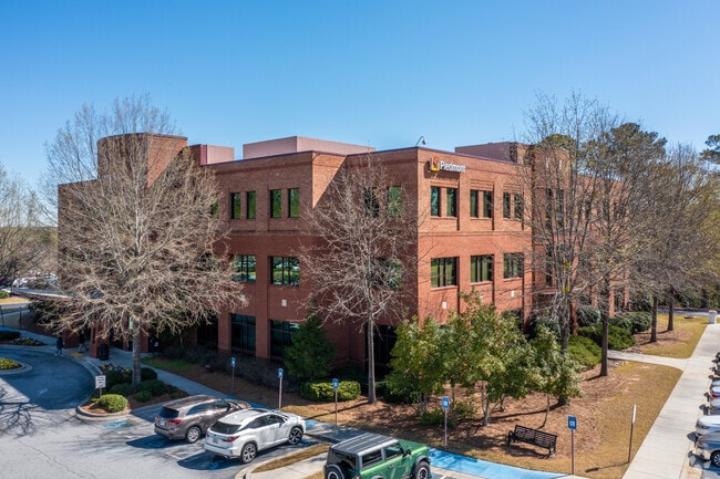
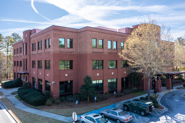
Property Record
1279 Highway 54 W, Fayetteville, GA 30214
NEARBY LISTINGS FOR SALE OR LEASE
Property Detail
1279 Highway 54 W
Atlanta-Sandy Springs-Roswell, GA
Robinsons Bend 02
07-04-00-022
PROFESSIONAL BLDG HWY 54 WEST
Medicalbuilding
Fayette
X
Georgia
13077C0200D
8
0
4.84 AC
2024
Fayette/Coweta County
140204
Atlanta
68,736 SF
DEMOGRAPHICS near 1279 Highway 54 W
1 Mile
3 Mile
5 Mile
2024 Total Population
1,467
19,018
59,722
2029 Population
1,574
20,419
63,654
Pop Growth 2024-2029
+ 7.29%
+ 7.37%
+ 6.58%
Average Age
42
43
43
2024 Total Households
510
6,926
21,864
HH Growth 2024-2029
+ 7.45%
+ 7.39%
+ 6.60%
Median Household Inc
$97,674
$92,435
$88,819
Avg Household Size
2.80
2.70
2.70
2024 Avg HH Vehicles
2.00
2.00
2.00
Median Home Value
$299,281
$334,001
$329,808
Median Year Built
2001
1995
1993
Nearby Places
Map Layers
Map Styles
 Street
 Aerial
- Restaurants
- Banks
- Shops
- Fitness
- Groceries
PUBLIC TRANSPORTATION
AIRPORT
Hartsfield - Jackson Atlanta International
DRIVE
WALK
Distance
Hartsfield - Jackson Atlanta International
34 min
19.3 mi
Freight Ports
Georgia Ports - Savannah
DRIVE
WALK
Distance
Georgia Ports - Savannah
278 min
240.9 mi
SALE & LEASE HISTORY
LISTING DATE
SALE/LEASE

Sep 25, 2016
For Lease
Sep 05, 2017
For Lease
Nearby Properties
Address
Land Use
TOTAL SIZE
Lot Size
Zoning
Address
Land Use
TOTAL SIZE
Lot Size
Zoning
293,819 SF
40.14 AC
C OI
Address
Land Use
TOTAL SIZE
Lot Size
Zoning
386,872 SF
PCD
Address
Land Use
TOTAL SIZE
Lot Size
Zoning
2,660 SF
C BP
Address
Land Use
TOTAL SIZE
Lot Size
Zoning
316,880 SF
285.84 AC
PCD
Address
Land Use
TOTAL SIZE
Lot Size
Zoning
197,026 SF
28 AC
Address
Land Use
TOTAL SIZE
Lot Size
Zoning
245,406 SF
51.77 AC
Address
Land Use
TOTAL SIZE
Lot Size
Zoning
151,194 SF
11.59 AC
C PUD
Address
Land Use
TOTAL SIZE
Lot Size
Zoning
155,706 SF
6.86 AC
PCD
Address
Land Use
TOTAL SIZE
Lot Size
Zoning
81,154 SF
23.70 AC
C OI
Address
Land Use
TOTAL SIZE
Lot Size
Zoning
84,975 SF
3.60 AC
PCD
Address
Land Use
TOTAL SIZE
Lot Size
Zoning
158,310 SF
4.76 AC
C C1
Address
Land Use
TOTAL SIZE
Lot Size
Zoning
40,392 SF
0.54 AC
C OI
Address
Land Use
TOTAL SIZE
Lot Size
Zoning
106,727 SF
25.85 AC
PCD
Address
Land Use
TOTAL SIZE
Lot Size
Zoning
39,704 SF
2.43 AC
C OI
Address
Land Use
TOTAL SIZE
Lot Size
Zoning
96,018 SF
PCD
Address
Land Use
TOTAL SIZE
Lot Size
Zoning
120,793 SF
5.60 AC
C PUD
Address
Land Use
TOTAL SIZE
Lot Size
Zoning
56,415 SF
2.44 AC
PCD
Address
Land Use
TOTAL SIZE
Lot Size
Zoning
122,568 SF
24.50 AC
PCD
Address
Land Use
TOTAL SIZE
Lot Size
Zoning
220,887 SF
24.70 AC
Address
Land Use
TOTAL SIZE
Lot Size
Zoning
57,172 SF
3.99 AC
PCD
Address
Land Use
TOTAL SIZE
Lot Size
Zoning
107,905 SF
13.23 AC
C C3
Address
Land Use
TOTAL SIZE
Lot Size
Zoning
239,954 SF
77.70 AC
Address
Land Use
TOTAL SIZE
Lot Size
Zoning
35,356 SF
2.01 AC
C C1
Address
Land Use
TOTAL SIZE
Lot Size
Zoning
85,939 SF
25.85 AC
PCD
Address
Land Use
TOTAL SIZE
Lot Size
Zoning
135,115 SF
32.15 AC
Address
Land Use
TOTAL SIZE
Lot Size
Zoning
56,192 SF
9.40 AC
C RMF15
Address
Land Use
TOTAL SIZE
Lot Size
Zoning
5,643 SF
22.42 AC
C OI
Address
Land Use
TOTAL SIZE
Lot Size
Zoning
68,298 SF
PCD
Address
Land Use
TOTAL SIZE
Lot Size
Zoning
25,004 SF
3.85 AC
C MO
The World's #1 Commercial Real Estate Marketplace
Connect with us
© 2025 CoStar Group
The information above has been obtained from sources believed reliable. While we do not doubt its accuracy we have not verified it and make no guarantee, warranty or representation about it. It is your responsibility to independently confirm its accuracy and completeness. Any projections, opinions, assumptions, or estimates used are for example only and do not represent the current or future performance of the property. The value of this transaction to you depends on tax and other factors which should be evaluated by your tax, financial, and legal advisors. You and your advisors should conduct a careful, independent investigation of the property to determine to your satisfaction the suitability of the property for your needs.