Property Record
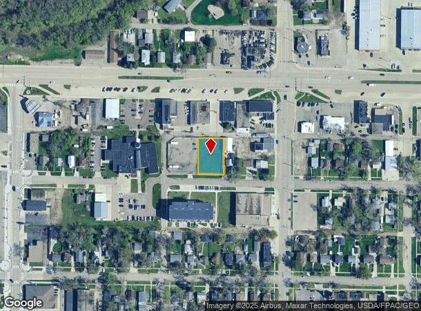
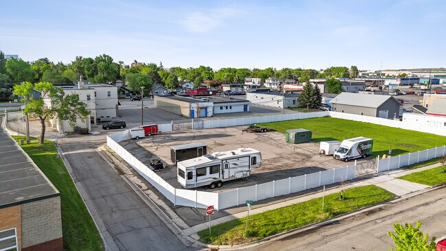
118 1St Ave W, West Fargo, ND 58078
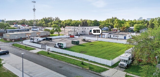
This Property Is For Sale
NEARBY LISTINGS FOR SALE OR LEASE
Property Detail
118 1St Ave W
Fargo, ND-MN
Sukut
02-2100-00270-000
LOT: 13 BLOCK: 2 ADDITION: SUKUTS ESTATES ADDITIONAL: SUKUT ESTATES LOTS 13 & 14 BLK 2
Commercialacreage
Cass
X
North Dakota
38017C0569G
13-14
2024
0.32 AC
2024
Fargo
010206
Other Market Areas
DEMOGRAPHICS near 118 1St Ave W
1 Mile
3 Mile
5 Mile
2024 Total Population
8,715
45,518
119,432
2029 Population
10,135
53,287
139,461
Pop Growth 2024-2029
+ 16.29%
+ 17.07%
+ 16.77%
Average Age
40
36
36
2024 Total Households
3,840
20,126
52,075
HH Growth 2024-2029
+ 16.72%
+ 17.58%
+ 17.37%
Median Household Inc
$66,922
$67,447
$65,580
Avg Household Size
2.20
2.20
2.20
2024 Avg HH Vehicles
2.00
2.00
2.00
Median Home Value
$206,250
$247,779
$252,189
Median Year Built
1975
1999
2000
Nearby Places
- Restaurants
- Banks
- Shops
- Fitness
- Groceries
PUBLIC TRANSPORTATION
COMMUTER RAIL
Fargo Amtrak Station (Empire Builder - Amtrak)
DRIVE
WALK
Distance
Fargo Amtrak Station (Empire Builder - Amtrak)
12 min
6.2 mi
AIRPORT
Hector International
DRIVE
WALK
Distance
Hector International
16 min
8.6 mi
Freight Ports
Port Milwaukee
DRIVE
WALK
Distance
Port Milwaukee
635 min
578.0 mi
Nearby Properties
Address
Land Use
TOTAL SIZE
Lot Size
Zoning
Address
Land Use
TOTAL SIZE
Lot Size
Zoning
408,617 SF
9.33 AC
GC
Address
Land Use
TOTAL SIZE
Lot Size
Zoning
122,006 SF
24.45 AC
GI
Address
Land Use
TOTAL SIZE
Lot Size
Zoning
418,024 SF
10.88 AC
Address
Land Use
TOTAL SIZE
Lot Size
Zoning
230,272 SF
21.77 AC
GC
Address
Land Use
TOTAL SIZE
Lot Size
Zoning
175,969 SF
35.10 AC
GI
Address
Land Use
TOTAL SIZE
Lot Size
Zoning
Address
Land Use
TOTAL SIZE
Lot Size
Zoning
163,195 SF
11.95 AC
GC
Address
Land Use
TOTAL SIZE
Lot Size
Zoning
131,309 SF
6.62 AC
GC
Address
Land Use
TOTAL SIZE
Lot Size
Zoning
34,100 SF
1.46 AC
MR3
Address
Land Use
TOTAL SIZE
Lot Size
Zoning
45.33 AC
GC
Address
Land Use
TOTAL SIZE
Lot Size
Zoning
48,300 SF
2.33 AC
MR3
Address
Land Use
TOTAL SIZE
Lot Size
Zoning
Address
Land Use
TOTAL SIZE
Lot Size
Zoning
37.39 AC
Address
Land Use
TOTAL SIZE
Lot Size
Zoning
152,509 SF
18.14 AC
Address
Land Use
TOTAL SIZE
Lot Size
Zoning
146,131 SF
15.67 AC
GO
Address
Land Use
TOTAL SIZE
Lot Size
Zoning
46,271 SF
2.06 AC
MR3
Address
Land Use
TOTAL SIZE
Lot Size
Zoning
206,540 SF
16.68 AC
GI
Address
Land Use
TOTAL SIZE
Lot Size
Zoning
41,046 SF
11.90 AC
Address
Land Use
TOTAL SIZE
Lot Size
Zoning
41,046 SF
11.78 AC
Address
Land Use
TOTAL SIZE
Lot Size
Zoning
104,817 SF
13.93 AC
GC
Address
Land Use
TOTAL SIZE
Lot Size
Zoning
794,266 SF
36.84 AC
GC
Address
Land Use
TOTAL SIZE
Lot Size
Zoning
190,588 SF
6.32 AC
Address
Land Use
TOTAL SIZE
Lot Size
Zoning
75 AC
MHP
Address
Land Use
TOTAL SIZE
Lot Size
Zoning
113,388 SF
3.41 AC
MR3
Address
Land Use
TOTAL SIZE
Lot Size
Zoning
218,579 SF
21.28 AC
GC
Address
Land Use
TOTAL SIZE
Lot Size
Zoning
49.50 AC
Address
Land Use
TOTAL SIZE
Lot Size
Zoning
152,508 SF
13.85 AC
GI
Address
Land Use
TOTAL SIZE
Lot Size
Zoning
Address
Land Use
TOTAL SIZE
Lot Size
Zoning
155,989 SF
11.62 AC
GC
Address
Land Use
TOTAL SIZE
Lot Size
Zoning
193,488 SF
8.27 AC
GC
The World's #1 Commercial Real Estate Marketplace
Connect with us
© 2025 CoStar Group
The information above has been obtained from sources believed reliable. While we do not doubt its accuracy we have not verified it and make no guarantee, warranty or representation about it. It is your responsibility to independently confirm its accuracy and completeness. Any projections, opinions, assumptions, or estimates used are for example only and do not represent the current or future performance of the property. The value of this transaction to you depends on tax and other factors which should be evaluated by your tax, financial, and legal advisors. You and your advisors should conduct a careful, independent investigation of the property to determine to your satisfaction the suitability of the property for your needs.