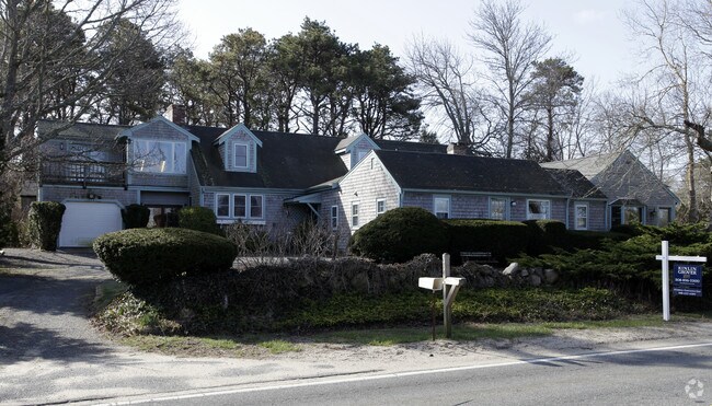
Property Record
128 Cranview Rd, Brewster, MA 02631


Save to a Folder
{{folder.Name}}
{{folder.ListingIds.length}} Properties
{{folder.ListingIds.length}} Property
Create a New Folder
Property Detail
128 Cranview Rd
Multifamilydwelling
Barnstable
RESD.
Massachusetts
C and X Area of minimal flood hazard, usually depicted on FIRMs as above the 500-year flood level.
5.17 AC
2025
Cape Cod
2025
Other Market Areas
010800
Barnstable Town, MA
1,341 SF
BREW-000020-000000-000015
NEARBY LISTINGS FOR SALE OR LEASE
DEMOGRAPHICS near 128 Cranview Rd
1 mile
3 mile
5 mile
2025 Total Population
870
8,234
26,140
2030 Population
882
8,342
26,459
Pop Growth 2025-2030
+ 1.38%
+ 1.31%
+ 1.22%
Average Age
53
54
52
2025 Total Households
403
3,945
12,130
HH Growth 2025-2030
+ 1.49%
+ 1.06%
+ 1.05%
Median Household Inc
$88,949
$88,898
$95,423
Avg Household Size
2.10
2.00
2.10
2025 Avg HH Vehicles
2.00
2.00
2.00
Median Home Value
$799,679
$775,925
$702,046
Median Year Built
1981
1981
1979
Nearby Places
Map Layers
Map Styles
 Street
 Aerial
Layers
 Traffic
 Biking
Places
Listings with unknown addresses are not visible on the map
- Restaurants
- Banks
- Shops
- Fitness
- Groceries
Nearby Properties
Address
Land Use
TOTAL SIZE
Lot Size
Zoning
Address
Land Use
TOTAL SIZE
Lot Size
Zoning
108,575 SF
0.48 AC
RESD.
Address
Land Use
TOTAL SIZE
Lot Size
Zoning
138,804 SF
15.94 AC
Address
Land Use
TOTAL SIZE
Lot Size
Zoning
12.93 AC
R
Address
Land Use
TOTAL SIZE
Lot Size
Zoning
83,860 SF
9.96 AC
RESD.
Address
Land Use
TOTAL SIZE
Lot Size
Zoning
34.40 AC
Address
Land Use
TOTAL SIZE
Lot Size
Zoning
3.71 AC
Address
Land Use
TOTAL SIZE
Lot Size
Zoning
6,517 SF
0.14 AC
DCPC
Address
Land Use
TOTAL SIZE
Lot Size
Zoning
320 SF
9.01 AC
Address
Land Use
TOTAL SIZE
Lot Size
Zoning
14.54 AC
Address
Land Use
TOTAL SIZE
Lot Size
Zoning
45.75 AC
R
Address
Land Use
TOTAL SIZE
Lot Size
Zoning
163.08 AC
Address
Land Use
TOTAL SIZE
Lot Size
Zoning
Address
Land Use
TOTAL SIZE
Lot Size
Zoning
38,518 SF
5.09 AC
Address
Land Use
TOTAL SIZE
Lot Size
Zoning
18.49 AC
Address
Land Use
TOTAL SIZE
Lot Size
Zoning
4 AC
R-60
Address
Land Use
TOTAL SIZE
Lot Size
Zoning
162.60 AC
Address
Land Use
TOTAL SIZE
Lot Size
Zoning
3,180 SF
2.05 AC
Address
Land Use
TOTAL SIZE
Lot Size
Zoning
35,131 SF
4.22 AC
Address
Land Use
TOTAL SIZE
Lot Size
Zoning
Address
Land Use
TOTAL SIZE
Lot Size
Zoning
Address
Land Use
TOTAL SIZE
Lot Size
Zoning
6,401 SF
7.07 AC
RESD.
Address
Land Use
TOTAL SIZE
Lot Size
Zoning
4,459 SF
10 AC
RESD.
Address
Land Use
TOTAL SIZE
Lot Size
Zoning
1,938 SF
5.50 AC
Address
Land Use
TOTAL SIZE
Lot Size
Zoning
Address
Land Use
TOTAL SIZE
Lot Size
Zoning
57,354 SF
5.47 AC
Address
Land Use
TOTAL SIZE
Lot Size
Zoning
184.84 AC
E
Address
Land Use
TOTAL SIZE
Lot Size
Zoning
Address
Land Use
TOTAL SIZE
Lot Size
Zoning
0.27 AC
R-60
Address
Land Use
TOTAL SIZE
Lot Size
Zoning
4,428 SF
28.60 AC
RESD.
Address
Land Use
TOTAL SIZE
Lot Size
Zoning
44,156 SF
3.90 AC
The World's #1 Commercial Real Estate Marketplace
Connect with us
© 2026 CoStar Group
The information above has been obtained from sources believed reliable. While we do not doubt its accuracy we have not verified it and make no guarantee, warranty or representation about it. It is your responsibility to independently confirm its accuracy and completeness. Any projections, opinions, assumptions, or estimates used are for example only and do not represent the current or future performance of the property. The value of this transaction to you depends on tax and other factors which should be evaluated by your tax, financial, and legal advisors. You and your advisors should conduct a careful, independent investigation of the property to determine to your satisfaction the suitability of the property for your needs.