Property Record
128 E State Route 128 Rd, Cleves, OH 45002
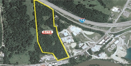

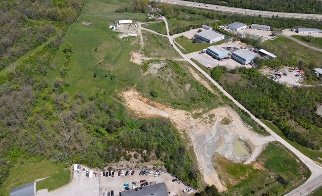
This Property Is For Sale
Property Detail
128 E State Route 128 Rd
Cincinnati, OH-KY-IN
STATE ROUTE 128 28.278 ACS R1E T1 S2,12PAR 8 & PG 40 PAR 32 CONS
630-0030-0008
HAMILTON
Livestock
Ohio
B and X Area of moderate flood hazard, usually the area between the limits of the 100-year and 500-year floods.
28.28 AC
2025
Forest Park/West
2025
Cincinnati/Dayton
020403
NEARBY LISTINGS FOR SALE OR LEASE
-
-
-
-
-
No Photo
-
-
-
View all Cleves listings for sale on LoopNet.com
DEMOGRAPHICS near 128 E State Route 128 Rd
1 mile
3 mile
5 mile
2025 Total Population
1,652
19,555
54,044
2030 Population
1,662
19,646
54,210
Pop Growth 2025-2030
+ 0.61%
+ 0.47%
+ 0.31%
Average Age
35
40
42
2025 Total Households
642
7,346
20,785
HH Growth 2025-2030
+ 0.47%
+ 0.38%
+ 0.26%
Median Household Inc
$72,773
$92,922
$94,061
Avg Household Size
2.60
2.60
2.50
2025 Avg HH Vehicles
2.00
2.00
2.00
Median Home Value
$342,613
$325,254
$294,961
Median Year Built
1986
1993
1985
Nearby Places
Map Layers
Map Styles
 Street
 Aerial
Layers
 Traffic
 Biking
Places
Listings with unknown addresses are not visible on the map
- Restaurants
- Banks
- Shops
- Fitness
- Groceries
PUBLIC TRANSPORTATION
AIRPORT
Cincinnati/Northern Kentucky International
Drive
Walk
Distance
Cincinnati/Northern Kentucky International
42 min
28.2 mi
Freight Ports
Port of Toledo
Drive
Walk
Distance
Port of Toledo
242 min
207.6 mi
Nearby Properties
Address
Land Use
TOTAL SIZE
Lot Size
Zoning
Address
Land Use
TOTAL SIZE
Lot Size
Zoning
5.38 AC
OO
Address
Land Use
TOTAL SIZE
Lot Size
Zoning
12.23 AC
Address
Land Use
TOTAL SIZE
Lot Size
Zoning
83.15 AC
Address
Land Use
TOTAL SIZE
Lot Size
Zoning
1,671 SF
21.48 AC
CCUP
Address
Land Use
TOTAL SIZE
Lot Size
Zoning
20.34 AC
Address
Land Use
TOTAL SIZE
Lot Size
Zoning
1,966 SF
74.07 AC
Address
Land Use
TOTAL SIZE
Lot Size
Zoning
8,580 SF
19.31 AC
DD
Address
Land Use
TOTAL SIZE
Lot Size
Zoning
35,496 SF
13.86 AC
A
Address
Land Use
TOTAL SIZE
Lot Size
Zoning
8.69 AC
EE
Address
Land Use
TOTAL SIZE
Lot Size
Zoning
2.76 AC
EE
Address
Land Use
TOTAL SIZE
Lot Size
Zoning
Address
Land Use
TOTAL SIZE
Lot Size
Zoning
37,169 SF
12.82 AC
A
Address
Land Use
TOTAL SIZE
Lot Size
Zoning
4,439 SF
1,059.01 AC
AA
Address
Land Use
TOTAL SIZE
Lot Size
Zoning
Address
Land Use
TOTAL SIZE
Lot Size
Zoning
69.35 AC
Address
Land Use
TOTAL SIZE
Lot Size
Zoning
Address
Land Use
TOTAL SIZE
Lot Size
Zoning
Address
Land Use
TOTAL SIZE
Lot Size
Zoning
Address
Land Use
TOTAL SIZE
Lot Size
Zoning
4.14 AC
EE
Address
Land Use
TOTAL SIZE
Lot Size
Zoning
4,679 SF
1.95 AC
Address
Land Use
TOTAL SIZE
Lot Size
Zoning
Address
Land Use
TOTAL SIZE
Lot Size
Zoning
5,282 SF
17.72 AC
Address
Land Use
TOTAL SIZE
Lot Size
Zoning
39,402 SF
4.01 AC
E
Address
Land Use
TOTAL SIZE
Lot Size
Zoning
3,382 SF
2.56 AC
Address
Land Use
TOTAL SIZE
Lot Size
Zoning
Address
Land Use
TOTAL SIZE
Lot Size
Zoning
996 SF
2.11 AC
EE
Address
Land Use
TOTAL SIZE
Lot Size
Zoning
3,360 SF
55.67 AC
Address
Land Use
TOTAL SIZE
Lot Size
Zoning
Address
Land Use
TOTAL SIZE
Lot Size
Zoning
2,996 SF
213.88 AC
Address
Land Use
TOTAL SIZE
Lot Size
Zoning
750 SF
6.15 AC
The World's #1 Commercial Real Estate Marketplace
Connect with us
© 2026 CoStar Group
The information above has been obtained from sources believed reliable. While we do not doubt its accuracy we have not verified it and make no guarantee, warranty or representation about it. It is your responsibility to independently confirm its accuracy and completeness. Any projections, opinions, assumptions, or estimates used are for example only and do not represent the current or future performance of the property. The value of this transaction to you depends on tax and other factors which should be evaluated by your tax, financial, and legal advisors. You and your advisors should conduct a careful, independent investigation of the property to determine to your satisfaction the suitability of the property for your needs.