Property Record
128 Rutledge Dr, Salem, VA 24153


Save to a Folder
{{folder.Name}}
{{folder.ListingIds.length}} Properties
{{folder.ListingIds.length}} Property
Create a New Folder
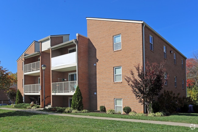
Property Detail
128 Rutledge Dr
59-1-4
TRACTS A & B 5.53 AC MAP OF CRAIG MANOR
Apartment
Salem
RMF
Virginia
B and X Area of moderate flood hazard, usually the area between the limits of the 100-year and 500-year floods.
5.53 AC
2025
Outlying Salem County
2025
Roanoke
010100
Roanoke, VA
10,770 SF
NEARBY LISTINGS FOR SALE OR LEASE
-
-
View all Salem listings for sale on LoopNet.com
DEMOGRAPHICS near 128 Rutledge Dr
1 mile
3 mile
5 mile
2025 Total Population
5,797
41,424
88,621
2030 Population
5,929
41,953
88,969
Pop Growth 2025-2030
+ 2.28%
+ 1.28%
+ 0.39%
Average Age
38
42
42
2025 Total Households
1,906
16,672
37,020
HH Growth 2025-2030
+ 2.47%
+ 1.39%
+ 0.36%
Median Household Inc
$74,862
$64,997
$64,823
Avg Household Size
2.30
2.30
2.30
2025 Avg HH Vehicles
2.00
2.00
2.00
Median Home Value
$359,904
$250,013
$258,640
Median Year Built
1973
1970
1968
Nearby Places
Map Layers
Map Styles
 Street
 Aerial
Layers
 Traffic
 Biking
Places
Listings with unknown addresses are not visible on the map
- Restaurants
- Banks
- Shops
- Fitness
- Groceries
PUBLIC TRANSPORTATION
AIRPORT
Roanoke/Blacksburg Regional (Woodrum Field)
Drive
Walk
Distance
Roanoke/Blacksburg Regional (Woodrum Field)
18 min
9.6 mi
Freight Ports
Virginia Port Authority - Richmond
Drive
Walk
Distance
Virginia Port Authority - Richmond
220 min
193.4 mi
Nearby Properties
Address
Land Use
TOTAL SIZE
Lot Size
Zoning
Address
Land Use
TOTAL SIZE
Lot Size
Zoning
160 AC
RSF
Address
Land Use
TOTAL SIZE
Lot Size
Zoning
81,148 SF
52.04 AC
CUDRSF
Address
Land Use
TOTAL SIZE
Lot Size
Zoning
288,464 SF
40.14 AC
RSF
Address
Land Use
TOTAL SIZE
Lot Size
Zoning
421,634 SF
15.99 AC
HBD
Address
Land Use
TOTAL SIZE
Lot Size
Zoning
69,831 SF
73.54 AC
HBD
Address
Land Use
TOTAL SIZE
Lot Size
Zoning
20,646 SF
23.33 AC
R2
Address
Land Use
TOTAL SIZE
Lot Size
Zoning
155,000 SF
3.78 AC
CUD
Address
Land Use
TOTAL SIZE
Lot Size
Zoning
83,167 SF
9.75 AC
C1
Address
Land Use
TOTAL SIZE
Lot Size
Zoning
181,455 SF
6.24 AC
RMF
Address
Land Use
TOTAL SIZE
Lot Size
Zoning
134,471 SF
16.39 AC
RMF
Address
Land Use
TOTAL SIZE
Lot Size
Zoning
95,349 SF
10.25 AC
RSF
Address
Land Use
TOTAL SIZE
Lot Size
Zoning
76,280 SF
9.51 AC
CUD
Address
Land Use
TOTAL SIZE
Lot Size
Zoning
138,887 SF
13.03 AC
HBD
Address
Land Use
TOTAL SIZE
Lot Size
Zoning
120,584 SF
9.41 AC
HM
Address
Land Use
TOTAL SIZE
Lot Size
Zoning
565,151 SF
56.04 AC
HM
Address
Land Use
TOTAL SIZE
Lot Size
Zoning
28,221 SF
20.18 AC
RMF
Address
Land Use
TOTAL SIZE
Lot Size
Zoning
161,757 SF
13.22 AC
HBD
Address
Land Use
TOTAL SIZE
Lot Size
Zoning
65,428 SF
34.05 AC
C1
Address
Land Use
TOTAL SIZE
Lot Size
Zoning
7,590 SF
14.18 AC
RMF
Address
Land Use
TOTAL SIZE
Lot Size
Zoning
442,530 SF
40.32 AC
HM
Address
Land Use
TOTAL SIZE
Lot Size
Zoning
47,451 SF
1.58 AC
RB
Address
Land Use
TOTAL SIZE
Lot Size
Zoning
314,182 SF
22.87 AC
HM
Address
Land Use
TOTAL SIZE
Lot Size
Zoning
100 SF
60.09 AC
RSF
Address
Land Use
TOTAL SIZE
Lot Size
Zoning
87,526 SF
4.12 AC
RMF
Address
Land Use
TOTAL SIZE
Lot Size
Zoning
11,613 SF
11.27 AC
RMF
Address
Land Use
TOTAL SIZE
Lot Size
Zoning
74,712 SF
2.13 AC
DBD
Address
Land Use
TOTAL SIZE
Lot Size
Zoning
72,042 SF
7.18 AC
C2
Address
Land Use
TOTAL SIZE
Lot Size
Zoning
100,915 SF
13.80 AC
HM
Address
Land Use
TOTAL SIZE
Lot Size
Zoning
178,638 SF
12.01 AC
HBD
Address
Land Use
TOTAL SIZE
Lot Size
Zoning
23,600 SF
24.55 AC
LM
The World's #1 Commercial Real Estate Marketplace
Connect with us
© 2026 CoStar Group
The information above has been obtained from sources believed reliable. While we do not doubt its accuracy we have not verified it and make no guarantee, warranty or representation about it. It is your responsibility to independently confirm its accuracy and completeness. Any projections, opinions, assumptions, or estimates used are for example only and do not represent the current or future performance of the property. The value of this transaction to you depends on tax and other factors which should be evaluated by your tax, financial, and legal advisors. You and your advisors should conduct a careful, independent investigation of the property to determine to your satisfaction the suitability of the property for your needs.