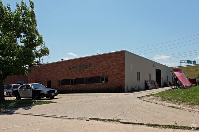
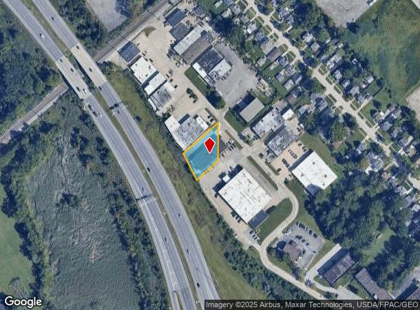
Property Record
1280 E 286Th St, Euclid, OH 44132

NEARBY LISTINGS FOR SALE OR LEASE
Property Detail
1280 E 286Th St
Cleveland-Elyria, OH
Willoughby
648-33-009
TR 20 AMBLER NWP & NEXT E 0011
Industrialgeneral
Cuyahoga
X
Ohio
39035C0101F
11
2024
0.46 AC
2024
Wickliffe/Willowick
196200
Cleveland
8,238 SF
DEMOGRAPHICS near 1280 E 286Th St
1 Mile
3 Mile
5 Mile
2024 Total Population
10,585
83,907
155,935
2029 Population
10,539
83,134
153,989
Pop Growth 2024-2029
(0.43%)
(0.92%)
(1.25%)
Average Age
38
42
43
2024 Total Households
4,545
38,675
72,346
HH Growth 2024-2029
(0.59%)
(0.93%)
(1.27%)
Median Household Inc
$47,193
$52,353
$51,594
Avg Household Size
2.20
2.10
2.10
2024 Avg HH Vehicles
2.00
2.00
2.00
Median Home Value
$115,544
$136,135
$148,254
Median Year Built
1959
1959
1959
Nearby Places
Map Layers
Map Styles
 Street
 Aerial
- Restaurants
- Banks
- Shops
- Fitness
- Groceries
PUBLIC TRANSPORTATION
AIRPORT
Cleveland-Hopkins International
DRIVE
WALK
Distance
Cleveland-Hopkins International
41 min
27.4 mi
SALE & LEASE HISTORY
LISTING DATE
SALE/LEASE

Apr 29, 2019
For Sale
Nearby Properties
Address
Land Use
TOTAL SIZE
Lot Size
Zoning
Address
Land Use
TOTAL SIZE
Lot Size
Zoning
71.14 AC
U4
Address
Land Use
TOTAL SIZE
Lot Size
Zoning
19,776 SF
13.41 AC
CI
Address
Land Use
TOTAL SIZE
Lot Size
Zoning
92,442 SF
159.84 AC
I-1
Address
Land Use
TOTAL SIZE
Lot Size
Zoning
1,283,872 SF
11.33 AC
U3
Address
Land Use
TOTAL SIZE
Lot Size
Zoning
827,164 SF
8 AC
U3
Address
Land Use
TOTAL SIZE
Lot Size
Zoning
190,580 SF
7.90 AC
P.F.
Address
Land Use
TOTAL SIZE
Lot Size
Zoning
208,119 SF
72.98 AC
1-R
Address
Land Use
TOTAL SIZE
Lot Size
Zoning
2.53 AC
U6
Address
Land Use
TOTAL SIZE
Lot Size
Zoning
39.06 AC
U6
Address
Land Use
TOTAL SIZE
Lot Size
Zoning
300,691 SF
36.39 AC
1R
Address
Land Use
TOTAL SIZE
Lot Size
Zoning
10,200 SF
23.91 AC
Address
Land Use
TOTAL SIZE
Lot Size
Zoning
399,945 SF
34.80 AC
CI
Address
Land Use
TOTAL SIZE
Lot Size
Zoning
34.14 AC
U6
Address
Land Use
TOTAL SIZE
Lot Size
Zoning
392,586 SF
6.50 AC
M
Address
Land Use
TOTAL SIZE
Lot Size
Zoning
27,466 SF
13.39 AC
U6
Address
Land Use
TOTAL SIZE
Lot Size
Zoning
92,659 SF
4.25 AC
M
Address
Land Use
TOTAL SIZE
Lot Size
Zoning
175,620 SF
8.65 AC
M
Address
Land Use
TOTAL SIZE
Lot Size
Zoning
208,610 SF
7.54 AC
M
Address
Land Use
TOTAL SIZE
Lot Size
Zoning
263,441 SF
17.18 AC
I
Address
Land Use
TOTAL SIZE
Lot Size
Zoning
70,574 SF
6.35 AC
CI
Address
Land Use
TOTAL SIZE
Lot Size
Zoning
417,806 SF
28.90 AC
Address
Land Use
TOTAL SIZE
Lot Size
Zoning
75,843 SF
10.23 AC
B
Address
Land Use
TOTAL SIZE
Lot Size
Zoning
71,569 SF
5.74 AC
M
Address
Land Use
TOTAL SIZE
Lot Size
Zoning
70,643 SF
8.26 AC
CI
Address
Land Use
TOTAL SIZE
Lot Size
Zoning
358,547 SF
8.22 AC
U3EL
Address
Land Use
TOTAL SIZE
Lot Size
Zoning
447,868 SF
6.22 AC
U3
Address
Land Use
TOTAL SIZE
Lot Size
Zoning
272,400 SF
1.07 AC
U2D
Address
Land Use
TOTAL SIZE
Lot Size
Zoning
65,558 SF
8.80 AC
M
Address
Land Use
TOTAL SIZE
Lot Size
Zoning
70,953 SF
8.66 AC
CI
Address
Land Use
TOTAL SIZE
Lot Size
Zoning
23.92 AC
U6
The World's #1 Commercial Real Estate Marketplace
Connect with us
© 2026 CoStar Group
The information above has been obtained from sources believed reliable. While we do not doubt its accuracy we have not verified it and make no guarantee, warranty or representation about it. It is your responsibility to independently confirm its accuracy and completeness. Any projections, opinions, assumptions, or estimates used are for example only and do not represent the current or future performance of the property. The value of this transaction to you depends on tax and other factors which should be evaluated by your tax, financial, and legal advisors. You and your advisors should conduct a careful, independent investigation of the property to determine to your satisfaction the suitability of the property for your needs.