Property Record
1280 Eighteen Mile Rd, Central, SC 29630


Current Lease Availabilities
NEARBY LISTINGS FOR SALE OR LEASE
-
-
View all Central listings for lease on LoopNet.com
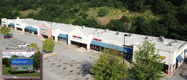
Property Detail
1280 Eighteen Mile Rd
4075-00-00-3276
The Right Of Ways Formed By Sc Highway
Stripcommercialcenter
SW/SIDE EIGHTEEN MILE RD PLAT 498/5
X
Pickens
45007C0085E
South Carolina
2025
6.04 AC
2024
Pickens County
011104
Greenville/Spartanburg
35,280 SF
Greenville-Anderson-Mauldin, SC
DEMOGRAPHICS near 1280 Eighteen Mile Rd
1 Mile
3 Mile
5 Mile
2024 Total Population
533
15,632
36,567
2029 Population
551
16,282
38,012
Pop Growth 2024-2029
+ 3.38%
+ 4.16%
+ 3.95%
Average Age
34
36
36
2024 Total Households
212
6,584
14,678
HH Growth 2024-2029
+ 3.30%
+ 4.34%
+ 4.20%
Median Household Inc
$28,749
$39,938
$42,534
Avg Household Size
2.10
2.20
2.30
2024 Avg HH Vehicles
1.00
2.00
2.00
Median Home Value
$171,052
$265,287
$226,814
Median Year Built
1986
1992
1990
Nearby Places
Map Layers
Map Styles
 Street
 Aerial
- Restaurants
- Banks
- Shops
- Fitness
- Groceries
PUBLIC TRANSPORTATION
COMMUTER RAIL
Clemson Amtrak Station (Crescent - Amtrak)
DRIVE
WALK
Distance
Clemson Amtrak Station (Crescent - Amtrak)
8 min
5.0 mi
Freight Ports
Georgia Ports - Savannah
DRIVE
WALK
Distance
Georgia Ports - Savannah
318 min
277.8 mi
Nearby Properties
Address
Land Use
TOTAL SIZE
Lot Size
Zoning
Address
Land Use
TOTAL SIZE
Lot Size
Zoning
5,208 SF
11.33 AC
RM16
Address
Land Use
TOTAL SIZE
Lot Size
Zoning
325,684 SF
19.26 AC
PD
Address
Land Use
TOTAL SIZE
Lot Size
Zoning
4,688 SF
10.93 AC
RM 3 MULTI
Address
Land Use
TOTAL SIZE
Lot Size
Zoning
3,160 SF
2.30 AC
RM16 RESID
Address
Land Use
TOTAL SIZE
Lot Size
Zoning
103.43 AC
Address
Land Use
TOTAL SIZE
Lot Size
Zoning
7,070 SF
2.59 AC
GENERAL CO
Address
Land Use
TOTAL SIZE
Lot Size
Zoning
17 AC
RIL RESEAR
Address
Land Use
TOTAL SIZE
Lot Size
Zoning
22.47 AC
Address
Land Use
TOTAL SIZE
Lot Size
Zoning
11,881 SF
2.02 AC
GENERAL CO
Address
Land Use
TOTAL SIZE
Lot Size
Zoning
7,692 SF
0.40 AC
RIL
Address
Land Use
TOTAL SIZE
Lot Size
Zoning
20,686 SF
15.84 AC
RM16
Address
Land Use
TOTAL SIZE
Lot Size
Zoning
10.09 AC
GC
Address
Land Use
TOTAL SIZE
Lot Size
Zoning
249,600 SF
12.61 AC
RM16
Address
Land Use
TOTAL SIZE
Lot Size
Zoning
20,927 SF
2.66 AC
GC
Address
Land Use
TOTAL SIZE
Lot Size
Zoning
22,500 SF
4.72 AC
Address
Land Use
TOTAL SIZE
Lot Size
Zoning
36.40 AC
RM 1 TWO F
Address
Land Use
TOTAL SIZE
Lot Size
Zoning
22,722 SF
12.68 AC
PD
Address
Land Use
TOTAL SIZE
Lot Size
Zoning
17,592 SF
10.67 AC
RM16 RESID
Address
Land Use
TOTAL SIZE
Lot Size
Zoning
64,306 SF
0.96 AC
RIL
Address
Land Use
TOTAL SIZE
Lot Size
Zoning
198 SF
6.26 AC
PD
Address
Land Use
TOTAL SIZE
Lot Size
Zoning
6,826 SF
0.33 AC
Address
Land Use
TOTAL SIZE
Lot Size
Zoning
196,017 SF
25.24 AC
GC
Address
Land Use
TOTAL SIZE
Lot Size
Zoning
6,377 SF
2.01 AC
GC
Address
Land Use
TOTAL SIZE
Lot Size
Zoning
14,868 SF
5.22 AC
PDD
Address
Land Use
TOTAL SIZE
Lot Size
Zoning
3,272 SF
25.98 AC
RM 3 MULTI
Address
Land Use
TOTAL SIZE
Lot Size
Zoning
121,807 SF
15.27 AC
PD
Address
Land Use
TOTAL SIZE
Lot Size
Zoning
3,770 SF
10.02 AC
RM16
Address
Land Use
TOTAL SIZE
Lot Size
Zoning
14,865 SF
4.63 AC
PD
Address
Land Use
TOTAL SIZE
Lot Size
Zoning
1,172 SF
10.25 AC
Address
Land Use
TOTAL SIZE
Lot Size
Zoning
68,705 SF
1.21 AC
UD
The World's #1 Commercial Real Estate Marketplace
Connect with us
© 2025 CoStar Group
The information above has been obtained from sources believed reliable. While we do not doubt its accuracy we have not verified it and make no guarantee, warranty or representation about it. It is your responsibility to independently confirm its accuracy and completeness. Any projections, opinions, assumptions, or estimates used are for example only and do not represent the current or future performance of the property. The value of this transaction to you depends on tax and other factors which should be evaluated by your tax, financial, and legal advisors. You and your advisors should conduct a careful, independent investigation of the property to determine to your satisfaction the suitability of the property for your needs.