Property Record
1280 S Interstate 35 S, New Braunfels, TX 78130
NEARBY LISTINGS FOR SALE OR LEASE
Property Detail
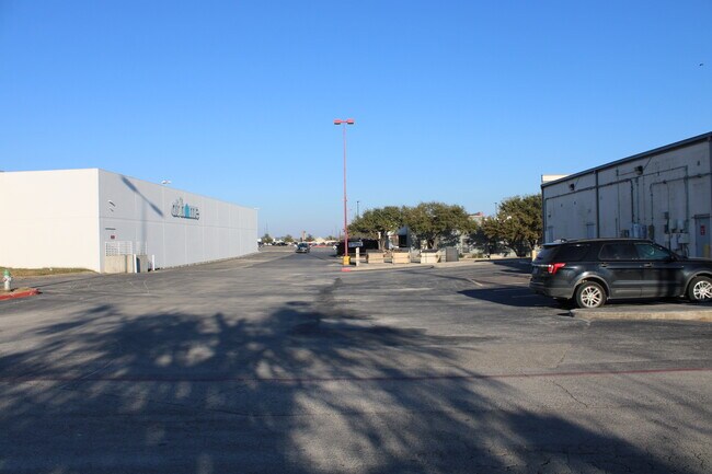
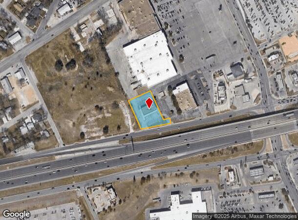
1280 S Interstate 35 S
San Antonio-New Braunfels, TX
Walnut Square Shopping Center
56-0215-0001-00
WALNUT SQUARE SHOPPING CENTER, LOT 1
Commercialnec
Comal
X
Texas
48091C0445F
1
2024
0.99 AC
2025
Comal County
310401
San Antonio
5,000 SF
DEMOGRAPHICS near 1280 S Interstate 35 S
1 mile
3 mile
5 mile
2024 Total Population
11,374
67,959
116,476
2029 Population
15,546
89,266
154,057
Pop Growth 2024-2029
+ 36.68%
+ 31.35%
+ 32.27%
Average Age
39
38
38
2024 Total Households
4,361
25,688
43,823
HH Growth 2024-2029
+ 36.44%
+ 31.92%
+ 32.80%
Median Household Inc
$77,812
$79,261
$84,183
Avg Household Size
2.50
2.60
2.60
2024 Avg HH Vehicles
2.00
2.00
2.00
Median Home Value
$245,408
$270,465
$280,476
Median Year Built
1982
1997
2004
Nearby Places
Map Layers
Map Styles
 Street
 Aerial
Transit
 Traffic
 Biking
Places
Listings with unknown addresses are not visible on the map
- Restaurants
- Banks
- Shops
- Fitness
- Groceries
PUBLIC TRANSPORTATION
AIRPORT
San Antonio International
Drive
Walk
Distance
San Antonio International
24 min
25.4 mi
Freight Ports
Calhoun Port
Drive
Walk
Distance
Calhoun Port
1 min
117.9 mi
SALE & LEASE HISTORY
LISTING DATE
SALE/LEASE

Mar 27, 2017
For Sale
Jan 11, 2017
For Sale
Jan 06, 2023
For Lease
Feb 01, 2017
For Sale
Nearby Properties
Address
Land Use
TOTAL SIZE
Lot Size
Zoning
Address
Land Use
TOTAL SIZE
Lot Size
Zoning
111.44 AC
Address
Land Use
TOTAL SIZE
Lot Size
Zoning
350,595 SF
21.78 AC
Address
Land Use
TOTAL SIZE
Lot Size
Zoning
234,823 SF
72.17 AC
Address
Land Use
TOTAL SIZE
Lot Size
Zoning
248,377 SF
23.66 AC
Address
Land Use
TOTAL SIZE
Lot Size
Zoning
433,083 SF
16.24 AC
Address
Land Use
TOTAL SIZE
Lot Size
Zoning
251,498 SF
8.63 AC
Address
Land Use
TOTAL SIZE
Lot Size
Zoning
381,528 SF
82.50 AC
Address
Land Use
TOTAL SIZE
Lot Size
Zoning
1.80 AC
Address
Land Use
TOTAL SIZE
Lot Size
Zoning
225,158 SF
52.63 AC
Address
Land Use
TOTAL SIZE
Lot Size
Zoning
170,266 SF
16.78 AC
Address
Land Use
TOTAL SIZE
Lot Size
Zoning
103,782 SF
105.82 AC
Address
Land Use
TOTAL SIZE
Lot Size
Zoning
215,244 SF
11.38 AC
Address
Land Use
TOTAL SIZE
Lot Size
Zoning
186,838 SF
14.53 AC
Address
Land Use
TOTAL SIZE
Lot Size
Zoning
135,975 SF
39.25 AC
Address
Land Use
TOTAL SIZE
Lot Size
Zoning
145,856 SF
9.52 AC
Address
Land Use
TOTAL SIZE
Lot Size
Zoning
88,620 SF
10.11 AC
Address
Land Use
TOTAL SIZE
Lot Size
Zoning
152,240 SF
14.13 AC
Address
Land Use
TOTAL SIZE
Lot Size
Zoning
397,600 SF
25.95 AC
Address
Land Use
TOTAL SIZE
Lot Size
Zoning
170,019 SF
4.46 AC
Address
Land Use
TOTAL SIZE
Lot Size
Zoning
188,600 SF
4.61 AC
Address
Land Use
TOTAL SIZE
Lot Size
Zoning
132,319 SF
8.80 AC
Address
Land Use
TOTAL SIZE
Lot Size
Zoning
97,200 SF
12.87 AC
Address
Land Use
TOTAL SIZE
Lot Size
Zoning
198,793 SF
9.38 AC
Address
Land Use
TOTAL SIZE
Lot Size
Zoning
105,729 SF
12.66 AC
Address
Land Use
TOTAL SIZE
Lot Size
Zoning
191,652 SF
19.03 AC
Address
Land Use
TOTAL SIZE
Lot Size
Zoning
76,180 SF
5.74 AC
Address
Land Use
TOTAL SIZE
Lot Size
Zoning
117,201 SF
4.72 AC
Address
Land Use
TOTAL SIZE
Lot Size
Zoning
61,079 SF
2.53 AC
Address
Land Use
TOTAL SIZE
Lot Size
Zoning
130,210 SF
13.57 AC
Address
Land Use
TOTAL SIZE
Lot Size
Zoning
205,071 SF
23.66 AC
The World's #1 Commercial Real Estate Marketplace
Connect with us
© 2026 CoStar Group
The information above has been obtained from sources believed reliable. While we do not doubt its accuracy we have not verified it and make no guarantee, warranty or representation about it. It is your responsibility to independently confirm its accuracy and completeness. Any projections, opinions, assumptions, or estimates used are for example only and do not represent the current or future performance of the property. The value of this transaction to you depends on tax and other factors which should be evaluated by your tax, financial, and legal advisors. You and your advisors should conduct a careful, independent investigation of the property to determine to your satisfaction the suitability of the property for your needs.