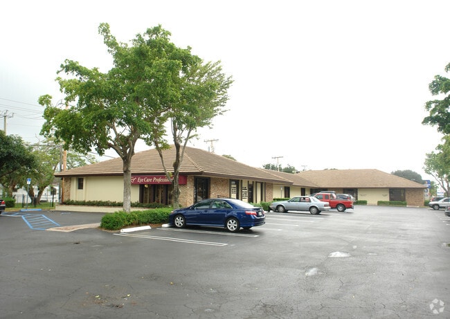
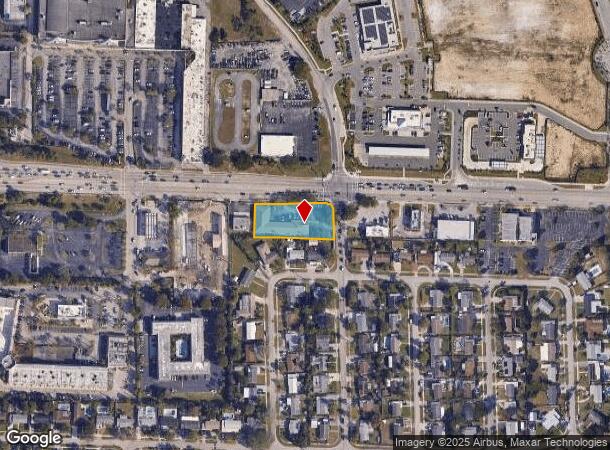
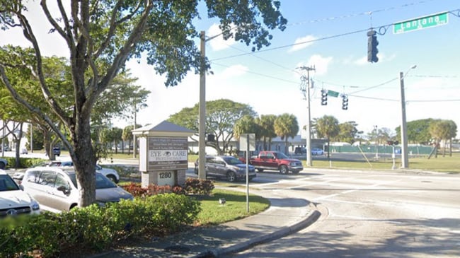
Property Record
1280 W Lantana Rd, Lantana, FL 33462

Current Lease Availabilities
NEARBY LISTINGS FOR SALE OR LEASE
Property Detail
1280 W Lantana Rd
West Palm Beach-Boca Raton-Delray Beach, FL
Lantana Heights Pl 2
40-43-45-04-05-009-0020
LANTANA HEIGHTS PL 2 LTS 2 & 3 (LESS I-95 R/W) & LOT 4 BLK 9
Officebuilding
Palm Beach
X
Florida
12099C0779F
2,3,4
2024
0.77 AC
2024
Boynton/Lantana
005815
South Florida
9,078 SF
DEMOGRAPHICS near 1280 W Lantana Rd
1 Mile
3 Mile
5 Mile
2024 Total Population
14,773
116,875
275,000
2029 Population
15,408
122,087
285,588
Pop Growth 2024-2029
+ 4.30%
+ 4.46%
+ 3.85%
Average Age
39
41
41
2024 Total Households
5,214
45,175
104,366
HH Growth 2024-2029
+ 4.10%
+ 4.83%
+ 4.08%
Median Household Inc
$56,978
$60,833
$62,773
Avg Household Size
2.60
2.40
2.50
2024 Avg HH Vehicles
2.00
2.00
2.00
Median Home Value
$273,850
$286,821
$292,671
Median Year Built
1970
1979
1981
Nearby Places
- Restaurants
- Banks
- Shops
- Fitness
- Groceries
PUBLIC TRANSPORTATION
COMMUTER RAIL
Lake Worth (Mangonia Park - Miami Airport - Tri-Rail, Tri-County Commuter - Tri-Rail)
DRIVE
WALK
Distance
Lake Worth (Mangonia Park - Miami Airport - Tri-Rail, Tri-County Commuter - Tri-Rail)
6 min
2.7 mi
Boynton Beach (Mangonia Park - Miami Airport - Tri-Rail, Tri-County Commuter - Tri-Rail)
DRIVE
WALK
Distance
Boynton Beach (Mangonia Park - Miami Airport - Tri-Rail, Tri-County Commuter - Tri-Rail)
7 min
3.3 mi
AIRPORT
Palm Beach International
DRIVE
WALK
Distance
Palm Beach International
14 min
9.3 mi
Freight Ports
Port of Palm Beach
DRIVE
WALK
Distance
Port of Palm Beach
24 min
14.7 mi
Nearby Properties
Address
Land Use
TOTAL SIZE
Lot Size
Zoning
Address
Land Use
TOTAL SIZE
Lot Size
Zoning
1,346,412 SF
23.09 AC
HD PUD
Address
Land Use
TOTAL SIZE
Lot Size
Zoning
337,437 SF
8.01 AC
C3
Address
Land Use
TOTAL SIZE
Lot Size
Zoning
508,032 SF
18 AC
MXD
Address
Land Use
TOTAL SIZE
Lot Size
Zoning
245,283 SF
7.40 AC
R-D(2)
Address
Land Use
TOTAL SIZE
Lot Size
Zoning
902,798 SF
112.99 AC
PO
Address
Land Use
TOTAL SIZE
Lot Size
Zoning
81,194 SF
675.47 AC
PO
Address
Land Use
TOTAL SIZE
Lot Size
Zoning
357,168 SF
16.13 AC
MXD
Address
Land Use
TOTAL SIZE
Lot Size
Zoning
327,864 SF
9.21 AC
MW
Address
Land Use
TOTAL SIZE
Lot Size
Zoning
311,983 SF
7.15 AC
C1
Address
Land Use
TOTAL SIZE
Lot Size
Zoning
443,576 SF
92.86 AC
PO
Address
Land Use
TOTAL SIZE
Lot Size
Zoning
353,007 SF
33.60 AC
RS
Address
Land Use
TOTAL SIZE
Lot Size
Zoning
211,774 SF
304.50 AC
PO
Address
Land Use
TOTAL SIZE
Lot Size
Zoning
437,380 SF
18.05 AC
PID
Address
Land Use
TOTAL SIZE
Lot Size
Zoning
214,095 SF
7.67 AC
PUD
Address
Land Use
TOTAL SIZE
Lot Size
Zoning
472,460 SF
38.76 AC
RM
Address
Land Use
TOTAL SIZE
Lot Size
Zoning
251,292 SF
18.59 AC
I-POC
Address
Land Use
TOTAL SIZE
Lot Size
Zoning
296,033 SF
2.04 AC
TOD-E
Address
Land Use
TOTAL SIZE
Lot Size
Zoning
178,602 SF
7.61 AC
MU-W
Address
Land Use
TOTAL SIZE
Lot Size
Zoning
291,589 SF
11.63 AC
PID
Address
Land Use
TOTAL SIZE
Lot Size
Zoning
99,412 SF
2.67 AC
R-D(2)
Address
Land Use
TOTAL SIZE
Lot Size
Zoning
344,466 SF
24.37 AC
P
Address
Land Use
TOTAL SIZE
Lot Size
Zoning
263,799 SF
8.36 AC
PUD
Address
Land Use
TOTAL SIZE
Lot Size
Zoning
201,733 SF
11.32 AC
RM
Address
Land Use
TOTAL SIZE
Lot Size
Zoning
7,284 SF
19.49 AC
BAC
Address
Land Use
TOTAL SIZE
Lot Size
Zoning
11,762 SF
1.46 AC
R1-C
Address
Land Use
TOTAL SIZE
Lot Size
Zoning
142,635 SF
10.66 AC
PID
Address
Land Use
TOTAL SIZE
Lot Size
Zoning
200,366 SF
12.59 AC
MU-W
Address
Land Use
TOTAL SIZE
Lot Size
Zoning
122,613 SF
63.40 AC
P
Address
Land Use
TOTAL SIZE
Lot Size
Zoning
58,081 SF
67.01 AC
MI
Address
Land Use
TOTAL SIZE
Lot Size
Zoning
97,059 SF
6.55 AC
PID
The World's #1 Commercial Real Estate Marketplace
Connect with us
© 2025 CoStar Group
The information above has been obtained from sources believed reliable. While we do not doubt its accuracy we have not verified it and make no guarantee, warranty or representation about it. It is your responsibility to independently confirm its accuracy and completeness. Any projections, opinions, assumptions, or estimates used are for example only and do not represent the current or future performance of the property. The value of this transaction to you depends on tax and other factors which should be evaluated by your tax, financial, and legal advisors. You and your advisors should conduct a careful, independent investigation of the property to determine to your satisfaction the suitability of the property for your needs.