Property Record
12800 Angel Side Dr, Leander, TX 78641
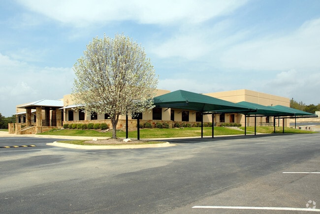


Property Detail
12800 Angel Side Dr
Austin-Round Rock-San Marcos, TX
LOT 1 ANGELSIDE OAKS
447947
Travis
Industrialgeneral
Texas
B and X Area of moderate flood hazard, usually the area between the limits of the 100-year and 500-year floods.
1
2025
13.98 AC
2025
Far Northwest
036200
Austin
30,370 SF
NEARBY LISTINGS FOR SALE OR LEASE
-
-
View all Leander listings for lease on LoopNet.com
DEMOGRAPHICS near 12800 Angel Side Dr
1 mile
3 mile
5 mile
2025 Total Population
2,225
26,663
98,462
2030 Population
2,432
29,251
110,137
Pop Growth 2025-2030
+ 9.30%
+ 9.71%
+ 11.86%
Average Age
40
40
38
2025 Total Households
726
9,048
34,303
HH Growth 2025-2030
+ 9.78%
+ 10.21%
+ 12.44%
Median Household Inc
$229,882
$178,764
$130,270
Avg Household Size
3.10
2.90
2.80
2025 Avg HH Vehicles
2.00
2.00
2.00
Median Home Value
$827,743
$689,920
$492,947
Median Year Built
2011
2010
2005
Nearby Places
Map Layers
Map Styles
 Street
 Aerial
Layers
 Traffic
 Biking
Places
Listings with unknown addresses are not visible on the map
- Restaurants
- Banks
- Shops
- Fitness
- Groceries
PUBLIC TRANSPORTATION
AIRPORT
Austin-Bergstrom International
Drive
Walk
Distance
Austin-Bergstrom International
54 min
37.7 mi
SALE & LEASE HISTORY
LISTING DATE
SALE/LEASE

Sep 12, 2017
For Lease
Jan 03, 2017
For Lease
Nearby Properties
Address
Land Use
TOTAL SIZE
Lot Size
Zoning
Address
Land Use
TOTAL SIZE
Lot Size
Zoning
264,140 SF
21.37 AC
Address
Land Use
TOTAL SIZE
Lot Size
Zoning
621.05 AC
Address
Land Use
TOTAL SIZE
Lot Size
Zoning
33.13 AC
Address
Land Use
TOTAL SIZE
Lot Size
Zoning
121,524 SF
9.34 AC
Address
Land Use
TOTAL SIZE
Lot Size
Zoning
158,700 SF
7.82 AC
Address
Land Use
TOTAL SIZE
Lot Size
Zoning
499.99 AC
Address
Land Use
TOTAL SIZE
Lot Size
Zoning
82,798 SF
9.28 AC
Address
Land Use
TOTAL SIZE
Lot Size
Zoning
16.01 AC
1-SFU
Address
Land Use
TOTAL SIZE
Lot Size
Zoning
48,168 SF
3.66 AC
Address
Land Use
TOTAL SIZE
Lot Size
Zoning
56,448 SF
13.65 AC
Address
Land Use
TOTAL SIZE
Lot Size
Zoning
116,934 SF
15.56 AC
4-GR
Address
Land Use
TOTAL SIZE
Lot Size
Zoning
19,436 SF
3.56 AC
Address
Land Use
TOTAL SIZE
Lot Size
Zoning
15.35 AC
Address
Land Use
TOTAL SIZE
Lot Size
Zoning
14.28 AC
Address
Land Use
TOTAL SIZE
Lot Size
Zoning
259.37 AC
Address
Land Use
TOTAL SIZE
Lot Size
Zoning
2,366 SF
6.68 AC
Address
Land Use
TOTAL SIZE
Lot Size
Zoning
15.60 AC
Address
Land Use
TOTAL SIZE
Lot Size
Zoning
Address
Land Use
TOTAL SIZE
Lot Size
Zoning
92,252 SF
10.12 AC
Address
Land Use
TOTAL SIZE
Lot Size
Zoning
12,796 SF
3.88 AC
Address
Land Use
TOTAL SIZE
Lot Size
Zoning
10,136 SF
1.28 AC
Address
Land Use
TOTAL SIZE
Lot Size
Zoning
160.30 AC
Address
Land Use
TOTAL SIZE
Lot Size
Zoning
13,714 SF
30.56 AC
Address
Land Use
TOTAL SIZE
Lot Size
Zoning
157.30 AC
Address
Land Use
TOTAL SIZE
Lot Size
Zoning
16.38 AC
Address
Land Use
TOTAL SIZE
Lot Size
Zoning
15,476 SF
7.07 AC
Address
Land Use
TOTAL SIZE
Lot Size
Zoning
30,675 SF
4.72 AC
Address
Land Use
TOTAL SIZE
Lot Size
Zoning
29,520 SF
1.53 AC
Address
Land Use
TOTAL SIZE
Lot Size
Zoning
1,314 SF
11.41 AC
Address
Land Use
TOTAL SIZE
Lot Size
Zoning
The World's #1 Commercial Real Estate Marketplace
Connect with us
© 2026 CoStar Group
The information above has been obtained from sources believed reliable. While we do not doubt its accuracy we have not verified it and make no guarantee, warranty or representation about it. It is your responsibility to independently confirm its accuracy and completeness. Any projections, opinions, assumptions, or estimates used are for example only and do not represent the current or future performance of the property. The value of this transaction to you depends on tax and other factors which should be evaluated by your tax, financial, and legal advisors. You and your advisors should conduct a careful, independent investigation of the property to determine to your satisfaction the suitability of the property for your needs.