Property Record
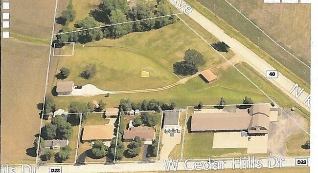
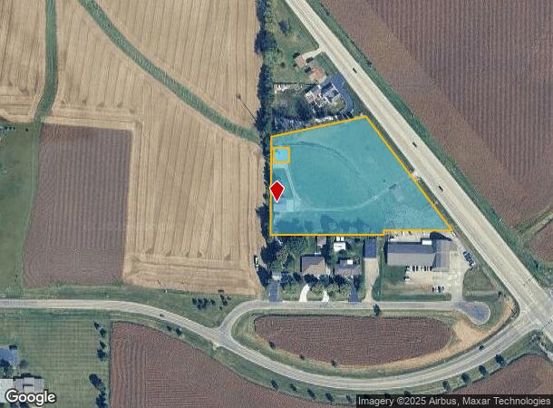
12801 N State Route 40, Dunlap, IL 61525
NEARBY LISTINGS FOR SALE OR LEASE
Property Detail
12801 N State Route 40
Peoria
Cedar Hills
Peoria, IL
SE 1/4 SEC 18-10N-8E 3.684 AC COMG INTERSEC N LN CEDAR HILLS DR & W LN ROUTE 40 TH NW ALG W LN ROUTE 40 276.56 TO POB: TH W 263.51 S 15 W 370.85 N 317.77 NE 334.4 TO W LN ROUTE 40 SE ALG W LN ROUTE 40 525.12 TO POB (EXC KNOXVILLE AVE ROW AS DESC
09-18-476-016
Peoria
Commercialnec
Illinois
2024
3.68 AC
2024
Outlying Peoria County
003900
DEMOGRAPHICS near 12801 N State Route 40
1 Mile
3 Mile
5 Mile
2024 Total Population
1,844
15,275
28,865
2029 Population
1,758
14,743
27,957
Pop Growth 2024-2029
(4.66%)
(3.48%)
(3.15%)
Average Age
39
37
39
2024 Total Households
666
5,607
11,404
HH Growth 2024-2029
(4.80%)
(3.76%)
(3.31%)
Median Household Inc
$99,718
$113,732
$98,797
Avg Household Size
2.70
2.70
2.50
2024 Avg HH Vehicles
2.00
2.00
2.00
Median Home Value
$235,344
$279,751
$245,409
Median Year Built
1977
2000
1991
Nearby Places
Map Layers
Map Styles
 Street
 Aerial
- Restaurants
- Banks
- Shops
- Fitness
- Groceries
PUBLIC TRANSPORTATION
AIRPORT
General Downing - Peoria International
DRIVE
WALK
Distance
General Downing - Peoria International
23 min
15.7 mi
Freight Ports
Port Milwaukee
DRIVE
WALK
Distance
Port Milwaukee
259 min
216.9 mi
SALE & LEASE HISTORY
LISTING DATE
SALE/LEASE

Sep 24, 2016
For Sale
Nearby Properties
Address
Land Use
TOTAL SIZE
Lot Size
Zoning
Address
Land Use
TOTAL SIZE
Lot Size
Zoning
46.02 AC
Address
Land Use
TOTAL SIZE
Lot Size
Zoning
11.62 AC
Address
Land Use
TOTAL SIZE
Lot Size
Zoning
Address
Land Use
TOTAL SIZE
Lot Size
Zoning
10.84 AC
Address
Land Use
TOTAL SIZE
Lot Size
Zoning
Address
Land Use
TOTAL SIZE
Lot Size
Zoning
3.51 AC
Address
Land Use
TOTAL SIZE
Lot Size
Zoning
1.88 AC
Address
Land Use
TOTAL SIZE
Lot Size
Zoning
7.62 AC
Address
Land Use
TOTAL SIZE
Lot Size
Zoning
Address
Land Use
TOTAL SIZE
Lot Size
Zoning
0.74 AC
Address
Land Use
TOTAL SIZE
Lot Size
Zoning
6.76 AC
Address
Land Use
TOTAL SIZE
Lot Size
Zoning
5.36 AC
Address
Land Use
TOTAL SIZE
Lot Size
Zoning
2.80 AC
Address
Land Use
TOTAL SIZE
Lot Size
Zoning
5.30 AC
Address
Land Use
TOTAL SIZE
Lot Size
Zoning
1.89 AC
Address
Land Use
TOTAL SIZE
Lot Size
Zoning
1.26 AC
Address
Land Use
TOTAL SIZE
Lot Size
Zoning
Address
Land Use
TOTAL SIZE
Lot Size
Zoning
7.44 AC
Address
Land Use
TOTAL SIZE
Lot Size
Zoning
1.38 AC
Address
Land Use
TOTAL SIZE
Lot Size
Zoning
1.72 AC
Address
Land Use
TOTAL SIZE
Lot Size
Zoning
3.16 AC
Address
Land Use
TOTAL SIZE
Lot Size
Zoning
0.39 AC
Address
Land Use
TOTAL SIZE
Lot Size
Zoning
Address
Land Use
TOTAL SIZE
Lot Size
Zoning
Address
Land Use
TOTAL SIZE
Lot Size
Zoning
Address
Land Use
TOTAL SIZE
Lot Size
Zoning
1.60 AC
Address
Land Use
TOTAL SIZE
Lot Size
Zoning
7.52 AC
Address
Land Use
TOTAL SIZE
Lot Size
Zoning
Address
Land Use
TOTAL SIZE
Lot Size
Zoning
6.28 AC
Address
Land Use
TOTAL SIZE
Lot Size
Zoning
1.15 AC
The World's #1 Commercial Real Estate Marketplace
Connect with us
© 2025 CoStar Group
The information above has been obtained from sources believed reliable. While we do not doubt its accuracy we have not verified it and make no guarantee, warranty or representation about it. It is your responsibility to independently confirm its accuracy and completeness. Any projections, opinions, assumptions, or estimates used are for example only and do not represent the current or future performance of the property. The value of this transaction to you depends on tax and other factors which should be evaluated by your tax, financial, and legal advisors. You and your advisors should conduct a careful, independent investigation of the property to determine to your satisfaction the suitability of the property for your needs.