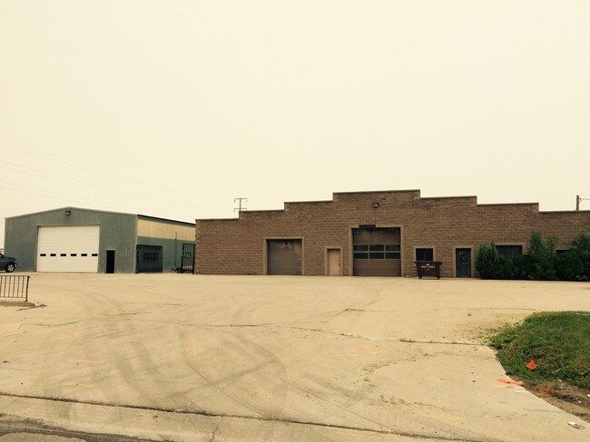
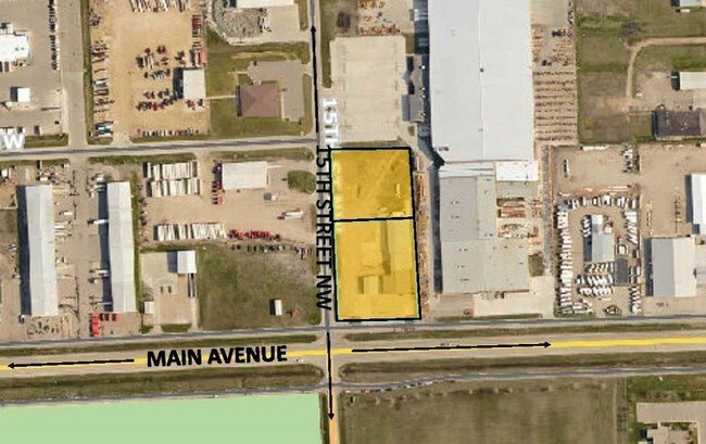
Property Record
1281 Main Ave W, West Fargo, ND 58078

NEARBY LISTINGS FOR SALE OR LEASE
-
-
No Photo
-
-
View all West Fargo listings for lease on LoopNet.com
Property Detail
1281 Main Ave W
Fargo, ND-MN
Butlers First Addition To The City Of We
02-0030-00090-000
LOT: 8 BLOCK: 1 ADDITION: BUTLER ADDITIONAL: BUTLER ADDITION LOT 8 BLK 1
Realpropertynec
Cass
X
North Dakota
38017C0568G
8
2024
2.23 AC
2024
Fargo
010201
Other Market Areas
20,704 SF
DEMOGRAPHICS near 1281 Main Ave W
1 Mile
3 Mile
5 Mile
2024 Total Population
2,083
27,520
76,826
2029 Population
2,208
29,551
82,560
Pop Growth 2024-2029
+ 6.00%
+ 7.38%
+ 7.46%
Average Age
39
37
35
2024 Total Households
889
11,385
33,376
HH Growth 2024-2029
+ 6.52%
+ 7.84%
+ 7.87%
Median Household Inc
$69,888
$79,259
$69,203
Avg Household Size
2.30
2.40
2.20
2024 Avg HH Vehicles
2.00
2.00
2.00
Median Home Value
$228,155
$247,053
$267,926
Median Year Built
1982
1997
2003
Nearby Places
Map Layers
Map Styles
 Street
 Aerial
- Restaurants
- Banks
- Shops
- Fitness
- Groceries
PUBLIC TRANSPORTATION
COMMUTER RAIL
DRIVE
WALK
Distance
14 min
7.5 mi
AIRPORT
Hector International
DRIVE
WALK
Distance
Hector International
18 min
9.9 mi
SALE & LEASE HISTORY
LISTING DATE
SALE/LEASE

Sep 24, 2016
For Sale
May 31, 2017
For Lease
Nearby Properties
Address
Land Use
TOTAL SIZE
Lot Size
Zoning
Address
Land Use
TOTAL SIZE
Lot Size
Zoning
152,509 SF
18.14 AC
Address
Land Use
TOTAL SIZE
Lot Size
Zoning
206,540 SF
16.68 AC
GI
Address
Land Use
TOTAL SIZE
Lot Size
Zoning
41,046 SF
11.90 AC
Address
Land Use
TOTAL SIZE
Lot Size
Zoning
41,046 SF
11.78 AC
Address
Land Use
TOTAL SIZE
Lot Size
Zoning
218,579 SF
21.28 AC
GC
Address
Land Use
TOTAL SIZE
Lot Size
Zoning
49.50 AC
Address
Land Use
TOTAL SIZE
Lot Size
Zoning
15,895 SF
41.76 AC
Address
Land Use
TOTAL SIZE
Lot Size
Zoning
184,560 SF
17.11 AC
Address
Land Use
TOTAL SIZE
Lot Size
Zoning
99,300 SF
12.72 AC
Address
Land Use
TOTAL SIZE
Lot Size
Zoning
207,189 SF
23.72 AC
Address
Land Use
TOTAL SIZE
Lot Size
Zoning
79,310 SF
17.79 AC
Address
Land Use
TOTAL SIZE
Lot Size
Zoning
354,677 SF
13.13 AC
Address
Land Use
TOTAL SIZE
Lot Size
Zoning
8,166 SF
8.26 AC
Address
Land Use
TOTAL SIZE
Lot Size
Zoning
101,324 SF
7.12 AC
LI
Address
Land Use
TOTAL SIZE
Lot Size
Zoning
156,450 SF
14.92 AC
Address
Land Use
TOTAL SIZE
Lot Size
Zoning
240,766 SF
15.14 AC
Address
Land Use
TOTAL SIZE
Lot Size
Zoning
131,360 SF
4.52 AC
Address
Land Use
TOTAL SIZE
Lot Size
Zoning
141,474 SF
16.03 AC
GC
Address
Land Use
TOTAL SIZE
Lot Size
Zoning
Address
Land Use
TOTAL SIZE
Lot Size
Zoning
180,000 SF
10.73 AC
Address
Land Use
TOTAL SIZE
Lot Size
Zoning
207,189 SF
22.99 AC
Address
Land Use
TOTAL SIZE
Lot Size
Zoning
4.84 AC
Address
Land Use
TOTAL SIZE
Lot Size
Zoning
13,970 SF
32.10 AC
Address
Land Use
TOTAL SIZE
Lot Size
Zoning
Address
Land Use
TOTAL SIZE
Lot Size
Zoning
79,192 SF
1.66 AC
Address
Land Use
TOTAL SIZE
Lot Size
Zoning
76,743 SF
5.69 AC
Address
Land Use
TOTAL SIZE
Lot Size
Zoning
16.39 AC
Address
Land Use
TOTAL SIZE
Lot Size
Zoning
193,114 SF
9.96 AC
Address
Land Use
TOTAL SIZE
Lot Size
Zoning
137,554 SF
10.48 AC
GC
Address
Land Use
TOTAL SIZE
Lot Size
Zoning
89,352 SF
2.59 AC
The World's #1 Commercial Real Estate Marketplace
Connect with us
© 2025 CoStar Group
The information above has been obtained from sources believed reliable. While we do not doubt its accuracy we have not verified it and make no guarantee, warranty or representation about it. It is your responsibility to independently confirm its accuracy and completeness. Any projections, opinions, assumptions, or estimates used are for example only and do not represent the current or future performance of the property. The value of this transaction to you depends on tax and other factors which should be evaluated by your tax, financial, and legal advisors. You and your advisors should conduct a careful, independent investigation of the property to determine to your satisfaction the suitability of the property for your needs.