Property Record
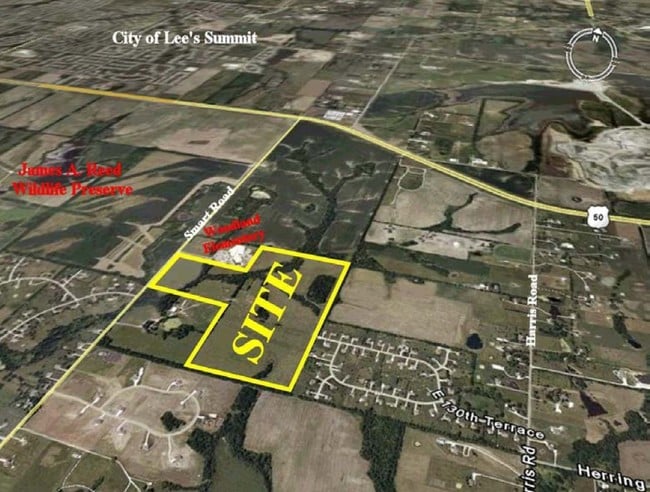
12811 Smart Rd, Lees Summit, MO 64086

Property Detail
12811 Smart Rd
60-700-03-01-01-0-00-000
SEC-13 TWP-47 RNG-31 TH PT OF S 1/2 OF NW 1/4 SW 1/4 & ALL O F TH NE 1/4 SW 1/4 (EX PT IN RD)
Agriculturalland
JACKSON
A Areas with a 1% annual chance of flooding and a 26% chance of flooding over the life of a 30-year mortgage.
Missouri
2024
56.74 AC
2025
Southeast Jackson County
013918
Kansas City
2,915 SF
Kansas City, MO-KS
NEARBY LISTINGS FOR SALE OR LEASE
-
-
View all Lees Summit listings for sale on LoopNet.com
DEMOGRAPHICS near 12811 Smart Rd
1 mile
3 mile
5 mile
2025 Total Population
548
12,877
54,101
2030 Population
556
12,991
54,713
Pop Growth 2025-2030
+ 1.46%
+ 0.89%
+ 1.13%
Average Age
47
39
39
2025 Total Households
188
4,379
20,160
HH Growth 2025-2030
+ 1.60%
+ 0.84%
+ 1.18%
Median Household Inc
$141,666
$124,604
$104,759
Avg Household Size
2.60
2.90
2.70
2025 Avg HH Vehicles
3.00
3.00
2.00
Median Home Value
$473,529
$339,250
$303,515
Median Year Built
1981
1995
1990
Nearby Places
Map Layers
Map Styles
 Street
 Aerial
Transit
 Traffic
 Biking
Places
Listings with unknown addresses are not visible on the map
- Restaurants
- Banks
- Shops
- Fitness
- Groceries
PUBLIC TRANSPORTATION
COMMUTER RAIL
Lee's Summit Amtrak (Lincoln Service Missouri River Runner - Amtrak, Missouri River Runner - Amtrak)
Drive
Walk
Distance
Lee's Summit Amtrak (Lincoln Service Missouri River Runner - Amtrak, Missouri River Runner - Amtrak)
12 min
6.4 mi
Freight Ports
Tulsa Port Of Catoosa
Drive
Walk
Distance
Tulsa Port Of Catoosa
265 min
239.3 mi
Nearby Properties
Address
Land Use
TOTAL SIZE
Lot Size
Zoning
Address
Land Use
TOTAL SIZE
Lot Size
Zoning
264,963 SF
Address
Land Use
TOTAL SIZE
Lot Size
Zoning
99,891 SF
9.71 AC
Address
Land Use
TOTAL SIZE
Lot Size
Zoning
65,290 SF
15.70 AC
Address
Land Use
TOTAL SIZE
Lot Size
Zoning
77,116 SF
36.96 AC
Address
Land Use
TOTAL SIZE
Lot Size
Zoning
145,562 SF
28.46 AC
Address
Land Use
TOTAL SIZE
Lot Size
Zoning
18,150 SF
Address
Land Use
TOTAL SIZE
Lot Size
Zoning
30,849 SF
4.99 AC
Address
Land Use
TOTAL SIZE
Lot Size
Zoning
69,752 SF
19.66 AC
Address
Land Use
TOTAL SIZE
Lot Size
Zoning
18,543 SF
6.59 AC
Address
Land Use
TOTAL SIZE
Lot Size
Zoning
26,508 SF
10.93 AC
Address
Land Use
TOTAL SIZE
Lot Size
Zoning
Address
Land Use
TOTAL SIZE
Lot Size
Zoning
4,433 SF
3.44 AC
Address
Land Use
TOTAL SIZE
Lot Size
Zoning
32,839 SF
10 AC
Address
Land Use
TOTAL SIZE
Lot Size
Zoning
125,931 SF
Address
Land Use
TOTAL SIZE
Lot Size
Zoning
396.50 AC
Address
Land Use
TOTAL SIZE
Lot Size
Zoning
24,407 SF
4.56 AC
Address
Land Use
TOTAL SIZE
Lot Size
Zoning
97,680 SF
6.20 AC
Address
Land Use
TOTAL SIZE
Lot Size
Zoning
8,979 SF
600 AC
Address
Land Use
TOTAL SIZE
Lot Size
Zoning
49,266 SF
3.86 AC
Address
Land Use
TOTAL SIZE
Lot Size
Zoning
558 SF
156.41 AC
Address
Land Use
TOTAL SIZE
Lot Size
Zoning
1,998 SF
0.77 AC
Address
Land Use
TOTAL SIZE
Lot Size
Zoning
235 AC
Address
Land Use
TOTAL SIZE
Lot Size
Zoning
23,696 SF
4.24 AC
Address
Land Use
TOTAL SIZE
Lot Size
Zoning
22,011 SF
5.09 AC
Address
Land Use
TOTAL SIZE
Lot Size
Zoning
30,750 SF
13.05 AC
Address
Land Use
TOTAL SIZE
Lot Size
Zoning
Address
Land Use
TOTAL SIZE
Lot Size
Zoning
12,688 SF
15 AC
Address
Land Use
TOTAL SIZE
Lot Size
Zoning
15,629 SF
4 AC
Address
Land Use
TOTAL SIZE
Lot Size
Zoning
12,264 SF
5.82 AC
Address
Land Use
TOTAL SIZE
Lot Size
Zoning
23,520 SF
3.79 AC
The World's #1 Commercial Real Estate Marketplace
Connect with us
© 2026 CoStar Group
The information above has been obtained from sources believed reliable. While we do not doubt its accuracy we have not verified it and make no guarantee, warranty or representation about it. It is your responsibility to independently confirm its accuracy and completeness. Any projections, opinions, assumptions, or estimates used are for example only and do not represent the current or future performance of the property. The value of this transaction to you depends on tax and other factors which should be evaluated by your tax, financial, and legal advisors. You and your advisors should conduct a careful, independent investigation of the property to determine to your satisfaction the suitability of the property for your needs.