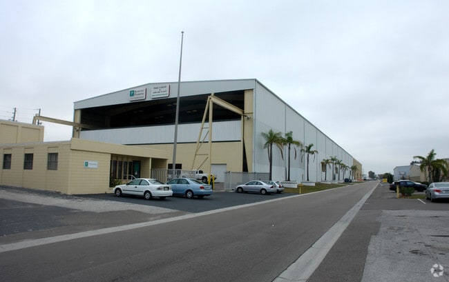
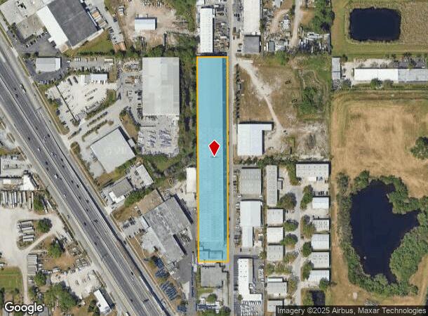
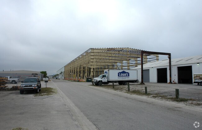
Property Record
12812 60Th St N, Clearwater, FL 33760

NEARBY LISTINGS FOR SALE OR LEASE
Property Detail
12812 60Th St N
Tampa-St. Petersburg-Clearwater, FL
Pinellas Groves
08-30-16-70974-100-1201
PINELLAS GROVES NE 1/4, W 1/2 OF N 1000FT OF LOT 12 LESS E 20FT FOR RD PER O.R. 14631/2023
Industrialgeneral
Pinellas
X
Florida
12103C0139H
12
2024
3.39 AC
2025
South Pinellas
024512
Tampa/St Petersburg
113,940 SF
DEMOGRAPHICS near 12812 60Th St N
1 Mile
3 Mile
5 Mile
2024 Total Population
3,984
74,144
222,775
2029 Population
4,079
74,200
224,184
Pop Growth 2024-2029
+ 2.38%
+ 0.08%
+ 0.63%
Average Age
46
45
45
2024 Total Households
1,867
33,414
102,967
HH Growth 2024-2029
+ 2.68%
(0.02%)
+ 0.53%
Median Household Inc
$48,410
$55,654
$57,279
Avg Household Size
2.00
2.10
2.10
2024 Avg HH Vehicles
1.00
2.00
2.00
Median Home Value
$102,160
$211,341
$216,816
Median Year Built
1987
1979
1977
Nearby Places
Map Layers
Map Styles
 Street
 Aerial
- Restaurants
- Banks
- Shops
- Fitness
- Groceries
PUBLIC TRANSPORTATION
AIRPORT
St Pete-Clearwater International
DRIVE
WALK
Distance
St Pete-Clearwater International
14 min
4.8 mi
Tampa International
DRIVE
WALK
Distance
Tampa International
26 min
16.3 mi
Freight Ports
Port of Tampa Bay
DRIVE
WALK
Distance
Port of Tampa Bay
35 min
21.7 mi
Nearby Properties
Address
Land Use
TOTAL SIZE
Lot Size
Zoning
Address
Land Use
TOTAL SIZE
Lot Size
Zoning
795,890 SF
69.11 AC
M1
Address
Land Use
TOTAL SIZE
Lot Size
Zoning
130,544 SF
1,313.50 AC
PCAIRPOR
Address
Land Use
TOTAL SIZE
Lot Size
Zoning
1,232,878 SF
12.64 AC
Address
Land Use
TOTAL SIZE
Lot Size
Zoning
372,013 SF
10.10 AC
Address
Land Use
TOTAL SIZE
Lot Size
Zoning
171,420 SF
300.24 AC
M1
Address
Land Use
TOTAL SIZE
Lot Size
Zoning
367,411 SF
16.12 AC
Address
Land Use
TOTAL SIZE
Lot Size
Zoning
382,389 SF
13.62 AC
Address
Land Use
TOTAL SIZE
Lot Size
Zoning
358,681 SF
11.70 AC
Address
Land Use
TOTAL SIZE
Lot Size
Zoning
337,954 SF
21 AC
R3
Address
Land Use
TOTAL SIZE
Lot Size
Zoning
402,681 SF
18.40 AC
Address
Land Use
TOTAL SIZE
Lot Size
Zoning
255,548 SF
21.69 AC
RPD10
Address
Land Use
TOTAL SIZE
Lot Size
Zoning
364,675 SF
66.40 AC
AE
Address
Land Use
TOTAL SIZE
Lot Size
Zoning
311,000 SF
15.50 AC
Address
Land Use
TOTAL SIZE
Lot Size
Zoning
384,124 SF
25.78 AC
C3
Address
Land Use
TOTAL SIZE
Lot Size
Zoning
446,556 SF
14.95 AC
M1
Address
Land Use
TOTAL SIZE
Lot Size
Zoning
396,822 SF
36.20 AC
RPD5
Address
Land Use
TOTAL SIZE
Lot Size
Zoning
362,618 SF
40.19 AC
R6
Address
Land Use
TOTAL SIZE
Lot Size
Zoning
266,396 SF
23.18 AC
Address
Land Use
TOTAL SIZE
Lot Size
Zoning
294,478 SF
44.79 AC
M1
Address
Land Use
TOTAL SIZE
Lot Size
Zoning
352,158 SF
47.45 AC
Address
Land Use
TOTAL SIZE
Lot Size
Zoning
160,014 SF
7.77 AC
Address
Land Use
TOTAL SIZE
Lot Size
Zoning
267,649 SF
17.86 AC
Address
Land Use
TOTAL SIZE
Lot Size
Zoning
582,271 SF
17.14 AC
Address
Land Use
TOTAL SIZE
Lot Size
Zoning
225,515 SF
26.82 AC
Address
Land Use
TOTAL SIZE
Lot Size
Zoning
249,699 SF
15 AC
Address
Land Use
TOTAL SIZE
Lot Size
Zoning
280,129 SF
Address
Land Use
TOTAL SIZE
Lot Size
Zoning
296,868 SF
20.99 AC
Address
Land Use
TOTAL SIZE
Lot Size
Zoning
159,073 SF
3.02 AC
Address
Land Use
TOTAL SIZE
Lot Size
Zoning
222,575 SF
15.03 AC
R3
Address
Land Use
TOTAL SIZE
Lot Size
Zoning
176,716 SF
14.20 AC
The World's #1 Commercial Real Estate Marketplace
Connect with us
© 2025 CoStar Group
The information above has been obtained from sources believed reliable. While we do not doubt its accuracy we have not verified it and make no guarantee, warranty or representation about it. It is your responsibility to independently confirm its accuracy and completeness. Any projections, opinions, assumptions, or estimates used are for example only and do not represent the current or future performance of the property. The value of this transaction to you depends on tax and other factors which should be evaluated by your tax, financial, and legal advisors. You and your advisors should conduct a careful, independent investigation of the property to determine to your satisfaction the suitability of the property for your needs.