Property Record
12815 Forest Park Dr, Olive Branch, MS 38654


Save to a Folder
{{folder.Name}}
{{folder.ListingIds.length}} Properties
{{folder.ListingIds.length}} Property
Create a New Folder
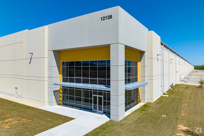
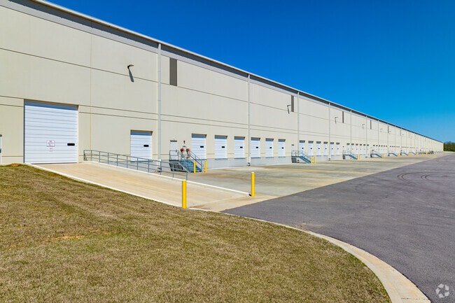
Property Detail
12815 Forest Park Dr
1059301000000200
FOREST PARK PLANNED DEV PH 2 LOT 2
Warehouse
DESOTO
PUD
Mississippi
B and X Area of moderate flood hazard, usually the area between the limits of the 100-year and 500-year floods.
2
2025
60.30 AC
2025
DeSoto
070821
Memphis
990,952 SF
Memphis, TN-MS-AR
NEARBY LISTINGS FOR SALE OR LEASE
DEMOGRAPHICS near 12815 Forest Park Dr
1 mile
3 mile
5 mile
2025 Total Population
805
23,343
81,693
2030 Population
837
23,883
81,818
Pop Growth 2025-2030
+ 3.98%
+ 2.31%
+ 0.15%
Average Age
37
37
38
2025 Total Households
268
8,609
30,203
HH Growth 2025-2030
+ 4.10%
+ 2.24%
+ 0.10%
Median Household Inc
$114,024
$86,120
$92,505
Avg Household Size
3.00
2.70
2.70
2025 Avg HH Vehicles
2.00
2.00
2.00
Median Home Value
$414,286
$278,942
$270,965
Median Year Built
2005
1999
1997
Nearby Places
Map Layers
Map Styles
 Street
 Aerial
Layers
 Traffic
 Biking
Places
Listings with unknown addresses are not visible on the map
- Restaurants
- Banks
- Shops
- Fitness
- Groceries
PUBLIC TRANSPORTATION
AIRPORT
Memphis International
Drive
Walk
Distance
Memphis International
30 min
17.9 mi
Freight Ports
Port of Shreveport
Drive
Walk
Distance
Port of Shreveport
434 min
391.6 mi
SALE & LEASE HISTORY
LISTING DATE
SALE/LEASE

Feb 02, 2018
For Lease
Nearby Properties
Address
Land Use
TOTAL SIZE
Lot Size
Zoning
Address
Land Use
TOTAL SIZE
Lot Size
Zoning
1,059,729 SF
74.33 AC
M-2
Address
Land Use
TOTAL SIZE
Lot Size
Zoning
929,880 SF
41.14 AC
M-1
Address
Land Use
TOTAL SIZE
Lot Size
Zoning
1,150,296 SF
68.41 AC
M-1
Address
Land Use
TOTAL SIZE
Lot Size
Zoning
1,093,788 SF
60.98 AC
M-1
Address
Land Use
TOTAL SIZE
Lot Size
Zoning
1,299,800 SF
50.22 AC
M-1
Address
Land Use
TOTAL SIZE
Lot Size
Zoning
990,080 SF
55.79 AC
M-1
Address
Land Use
TOTAL SIZE
Lot Size
Zoning
622,675 SF
67.55 AC
M-1
Address
Land Use
TOTAL SIZE
Lot Size
Zoning
761,349 SF
57.62 AC
M-1
Address
Land Use
TOTAL SIZE
Lot Size
Zoning
722,560 SF
66.85 AC
M-1
Address
Land Use
TOTAL SIZE
Lot Size
Zoning
615,853 SF
39.07 AC
M-1
Address
Land Use
TOTAL SIZE
Lot Size
Zoning
869,020 SF
43.85 AC
M-1
Address
Land Use
TOTAL SIZE
Lot Size
Zoning
813,440 SF
38.72 AC
PB
Address
Land Use
TOTAL SIZE
Lot Size
Zoning
616,191 SF
61.92 AC
PUD
Address
Land Use
TOTAL SIZE
Lot Size
Zoning
860,040 SF
43.13 AC
M-1
Address
Land Use
TOTAL SIZE
Lot Size
Zoning
927,742 SF
42.73 AC
PB
Address
Land Use
TOTAL SIZE
Lot Size
Zoning
416,000 SF
40.66 AC
M-1
Address
Land Use
TOTAL SIZE
Lot Size
Zoning
447,008 SF
28.41 AC
PB
Address
Land Use
TOTAL SIZE
Lot Size
Zoning
689,628 SF
43.78 AC
M-1
Address
Land Use
TOTAL SIZE
Lot Size
Zoning
599,752 SF
40.17 AC
M-1
Address
Land Use
TOTAL SIZE
Lot Size
Zoning
1,082,465 SF
57.74 AC
PB
Address
Land Use
TOTAL SIZE
Lot Size
Zoning
596,400 SF
43.20 AC
M-2
Address
Land Use
TOTAL SIZE
Lot Size
Zoning
399,672 SF
19.97 AC
M-1
Address
Land Use
TOTAL SIZE
Lot Size
Zoning
430,503 SF
21.24 AC
M-1
Address
Land Use
TOTAL SIZE
Lot Size
Zoning
340,000 SF
28.56 AC
M-2
Address
Land Use
TOTAL SIZE
Lot Size
Zoning
27,669 SF
34.27 AC
R-4
Address
Land Use
TOTAL SIZE
Lot Size
Zoning
480,000 SF
23.80 AC
M-2
Address
Land Use
TOTAL SIZE
Lot Size
Zoning
81,018 SF
18.09 AC
CA
Address
Land Use
TOTAL SIZE
Lot Size
Zoning
413,028 SF
28.15 AC
M-1
Address
Land Use
TOTAL SIZE
Lot Size
Zoning
377,821 SF
22.08 AC
PB
The World's #1 Commercial Real Estate Marketplace
Connect with us
© 2026 CoStar Group
The information above has been obtained from sources believed reliable. While we do not doubt its accuracy we have not verified it and make no guarantee, warranty or representation about it. It is your responsibility to independently confirm its accuracy and completeness. Any projections, opinions, assumptions, or estimates used are for example only and do not represent the current or future performance of the property. The value of this transaction to you depends on tax and other factors which should be evaluated by your tax, financial, and legal advisors. You and your advisors should conduct a careful, independent investigation of the property to determine to your satisfaction the suitability of the property for your needs.