Property Record
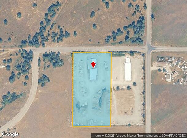
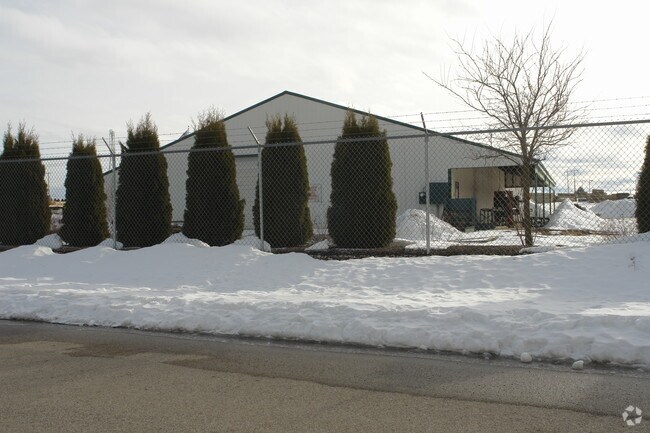
12815 N Greensferry Rd, Rathdrum, ID 83858

NEARBY LISTINGS FOR SALE OR LEASE
Property Detail
12815 N Greensferry Rd
51N05W110100
Ne-Ne
Industrialgeneral
W2-NE-NE-NE EX RD RW 1151N05W
X
Kootenai
16055C0225E
Idaho
2025
4.81 AC
2025
Post Falls
000304
Coeur D'Alene
9,092 SF
Coeur d'Alene, ID
DEMOGRAPHICS near 12815 N Greensferry Rd
1 Mile
3 Mile
5 Mile
2024 Total Population
996
12,623
49,830
2029 Population
1,186
15,115
59,542
Pop Growth 2024-2029
+ 19.08%
+ 19.74%
+ 19.49%
Average Age
42
38
38
2024 Total Households
389
4,539
18,219
HH Growth 2024-2029
+ 18.77%
+ 19.37%
+ 19.11%
Median Household Inc
$59,999
$74,429
$74,593
Avg Household Size
2.50
2.80
2.70
2024 Avg HH Vehicles
2.00
2.00
2.00
Median Home Value
$526,846
$436,656
$421,501
Median Year Built
2005
2003
2006
Nearby Places
Map Layers
Map Styles
 Street
 Aerial
- Restaurants
- Banks
- Shops
- Fitness
- Groceries
PUBLIC TRANSPORTATION
AIRPORT
Spokane International
DRIVE
WALK
Distance
Spokane International
51 min
38.3 mi
Nearby Properties
Address
Land Use
TOTAL SIZE
Lot Size
Zoning
Address
Land Use
TOTAL SIZE
Lot Size
Zoning
20,822 SF
10.32 AC
AG
Address
Land Use
TOTAL SIZE
Lot Size
Zoning
125,872 SF
37.45 AC
Address
Land Use
TOTAL SIZE
Lot Size
Zoning
12,600 SF
29.04 AC
Address
Land Use
TOTAL SIZE
Lot Size
Zoning
14,159 SF
17.50 AC
Address
Land Use
TOTAL SIZE
Lot Size
Zoning
54,488 SF
19.50 AC
Address
Land Use
TOTAL SIZE
Lot Size
Zoning
124,611 SF
30.51 AC
AGSUB
Address
Land Use
TOTAL SIZE
Lot Size
Zoning
134,124 SF
43.63 AC
AG
Address
Land Use
TOTAL SIZE
Lot Size
Zoning
23,784 SF
7 AC
Address
Land Use
TOTAL SIZE
Lot Size
Zoning
48,264 SF
10.87 AC
Address
Land Use
TOTAL SIZE
Lot Size
Zoning
47,716 SF
17.22 AC
Address
Land Use
TOTAL SIZE
Lot Size
Zoning
88,688 SF
20.51 AC
Address
Land Use
TOTAL SIZE
Lot Size
Zoning
49,446 SF
5.25 AC
Address
Land Use
TOTAL SIZE
Lot Size
Zoning
52,690 SF
7.13 AC
Address
Land Use
TOTAL SIZE
Lot Size
Zoning
24,698 SF
5.02 AC
AGSUB
Address
Land Use
TOTAL SIZE
Lot Size
Zoning
42,000 SF
2.54 AC
Address
Land Use
TOTAL SIZE
Lot Size
Zoning
68,580 SF
4.36 AC
Address
Land Use
TOTAL SIZE
Lot Size
Zoning
60,220 SF
2.70 AC
Address
Land Use
TOTAL SIZE
Lot Size
Zoning
10,892 SF
38.79 AC
Address
Land Use
TOTAL SIZE
Lot Size
Zoning
15.19 AC
Address
Land Use
TOTAL SIZE
Lot Size
Zoning
34,635 SF
4.99 AC
Address
Land Use
TOTAL SIZE
Lot Size
Zoning
7,741 SF
111.49 AC
IND
Address
Land Use
TOTAL SIZE
Lot Size
Zoning
37,756 SF
2.89 AC
Address
Land Use
TOTAL SIZE
Lot Size
Zoning
29,190 SF
10.38 AC
Address
Land Use
TOTAL SIZE
Lot Size
Zoning
11,003 SF
2.07 AC
Address
Land Use
TOTAL SIZE
Lot Size
Zoning
25,785 SF
1.83 AC
Address
Land Use
TOTAL SIZE
Lot Size
Zoning
5,400 SF
39.85 AC
Address
Land Use
TOTAL SIZE
Lot Size
Zoning
53,654 SF
7.16 AC
Address
Land Use
TOTAL SIZE
Lot Size
Zoning
18,330 SF
3.60 AC
Address
Land Use
TOTAL SIZE
Lot Size
Zoning
11,604 SF
2.61 AC
The World's #1 Commercial Real Estate Marketplace
Connect with us
© 2025 CoStar Group
The information above has been obtained from sources believed reliable. While we do not doubt its accuracy we have not verified it and make no guarantee, warranty or representation about it. It is your responsibility to independently confirm its accuracy and completeness. Any projections, opinions, assumptions, or estimates used are for example only and do not represent the current or future performance of the property. The value of this transaction to you depends on tax and other factors which should be evaluated by your tax, financial, and legal advisors. You and your advisors should conduct a careful, independent investigation of the property to determine to your satisfaction the suitability of the property for your needs.