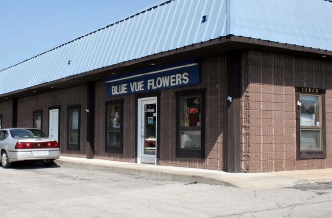
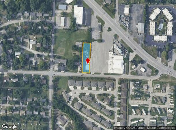
Property Record
12820 E 47Th St S, Independence, MO 64055
NEARBY LISTINGS FOR SALE OR LEASE
Property Detail
12820 E 47Th St S
Kansas City, MO-KS
Twiehaus Add
33-410-23-26-00-0-00-000
TWIEHAUS ADDITION PT OF LOT 2 DAF: BEG SW COR LOT 2 TH S 89 DEG E 286.91 TO TRU POB TH CONT S 89 DEG E 82 TH N 312.7 TH N 89 DEG W W 82 TH S 311.88 TO TRU POB (PT KNOWN AS TR
Regionalshoppingcenterormallwithanchorstore
Jackson
X
Missouri
29095C0291G
2
2024
0.59 AC
2025
East Jackson County
012400
Kansas City
3,552 SF
DEMOGRAPHICS near 12820 E 47Th St S
1 Mile
3 Mile
5 Mile
2024 Total Population
9,477
63,407
153,213
2029 Population
9,393
62,599
152,132
Pop Growth 2024-2029
(0.89%)
(1.27%)
(0.71%)
Average Age
43
42
42
2024 Total Households
3,959
26,706
64,326
HH Growth 2024-2029
(1.04%)
(1.43%)
(0.83%)
Median Household Inc
$65,297
$62,608
$59,411
Avg Household Size
2.30
2.30
2.30
2024 Avg HH Vehicles
2.00
2.00
2.00
Median Home Value
$157,751
$162,751
$162,628
Median Year Built
1965
1967
1967
Nearby Places
Map Layers
Map Styles
 Street
 Aerial
- Restaurants
- Banks
- Shops
- Fitness
- Groceries
PUBLIC TRANSPORTATION
COMMUTER RAIL
Independence Amtrak Station (Lincoln Service Missouri River Runner - Amtrak, Missouri River Runner - Amtrak)
DRIVE
WALK
Distance
Independence Amtrak Station (Lincoln Service Missouri River Runner - Amtrak, Missouri River Runner - Amtrak)
7 min
4.0 mi
AIRPORT
Kansas City International
DRIVE
WALK
Distance
Kansas City International
41 min
30.4 mi
Freight Ports
Tulsa Port Of Catoosa
DRIVE
WALK
Distance
Tulsa Port Of Catoosa
272 min
240.7 mi
Nearby Properties
Address
Land Use
TOTAL SIZE
Lot Size
Zoning
Address
Land Use
TOTAL SIZE
Lot Size
Zoning
519,315 SF
28.47 AC
Address
Land Use
TOTAL SIZE
Lot Size
Zoning
455,100 SF
42.02 AC
Address
Land Use
TOTAL SIZE
Lot Size
Zoning
64,318 SF
32.40 AC
Address
Land Use
TOTAL SIZE
Lot Size
Zoning
96,348 SF
14.42 AC
Address
Land Use
TOTAL SIZE
Lot Size
Zoning
74,801 SF
8.93 AC
Address
Land Use
TOTAL SIZE
Lot Size
Zoning
210,008 SF
16.89 AC
Address
Land Use
TOTAL SIZE
Lot Size
Zoning
139,713 SF
15.70 AC
Address
Land Use
TOTAL SIZE
Lot Size
Zoning
389,227 SF
33.30 AC
Address
Land Use
TOTAL SIZE
Lot Size
Zoning
42,188 SF
7.82 AC
Address
Land Use
TOTAL SIZE
Lot Size
Zoning
147,000 SF
Address
Land Use
TOTAL SIZE
Lot Size
Zoning
48,664 SF
8.44 AC
Address
Land Use
TOTAL SIZE
Lot Size
Zoning
190,810 SF
26.90 AC
Address
Land Use
TOTAL SIZE
Lot Size
Zoning
23,925 SF
19.96 AC
Address
Land Use
TOTAL SIZE
Lot Size
Zoning
45,832 SF
8.61 AC
Address
Land Use
TOTAL SIZE
Lot Size
Zoning
103,866 SF
13.29 AC
Address
Land Use
TOTAL SIZE
Lot Size
Zoning
66,168 SF
44.98 AC
Address
Land Use
TOTAL SIZE
Lot Size
Zoning
145,569 SF
16.90 AC
Address
Land Use
TOTAL SIZE
Lot Size
Zoning
114,248 SF
5.02 AC
Address
Land Use
TOTAL SIZE
Lot Size
Zoning
80,433 SF
7.24 AC
Address
Land Use
TOTAL SIZE
Lot Size
Zoning
111,617 SF
9.12 AC
Address
Land Use
TOTAL SIZE
Lot Size
Zoning
111,120 SF
12.61 AC
Address
Land Use
TOTAL SIZE
Lot Size
Zoning
81,990 SF
3.47 AC
Address
Land Use
TOTAL SIZE
Lot Size
Zoning
71,368 SF
5.64 AC
Address
Land Use
TOTAL SIZE
Lot Size
Zoning
175,442 SF
11.54 AC
Address
Land Use
TOTAL SIZE
Lot Size
Zoning
80,414 SF
6.79 AC
Address
Land Use
TOTAL SIZE
Lot Size
Zoning
103,500 SF
1.37 AC
Address
Land Use
TOTAL SIZE
Lot Size
Zoning
43,750 SF
6.05 AC
Address
Land Use
TOTAL SIZE
Lot Size
Zoning
58,800 SF
5.72 AC
Address
Land Use
TOTAL SIZE
Lot Size
Zoning
71,078 SF
9.50 AC
Address
Land Use
TOTAL SIZE
Lot Size
Zoning
93,834 SF
4.80 AC
The World's #1 Commercial Real Estate Marketplace
Connect with us
© 2025 CoStar Group
The information above has been obtained from sources believed reliable. While we do not doubt its accuracy we have not verified it and make no guarantee, warranty or representation about it. It is your responsibility to independently confirm its accuracy and completeness. Any projections, opinions, assumptions, or estimates used are for example only and do not represent the current or future performance of the property. The value of this transaction to you depends on tax and other factors which should be evaluated by your tax, financial, and legal advisors. You and your advisors should conduct a careful, independent investigation of the property to determine to your satisfaction the suitability of the property for your needs.