Property Record
12825 W 14Th Ave, Airway Heights, WA 99001
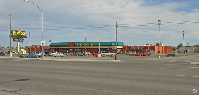
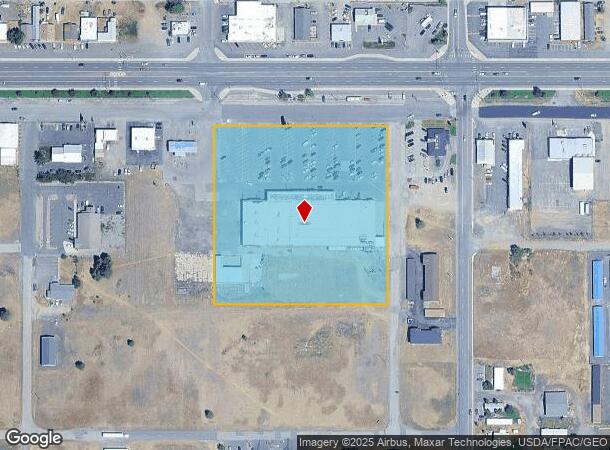
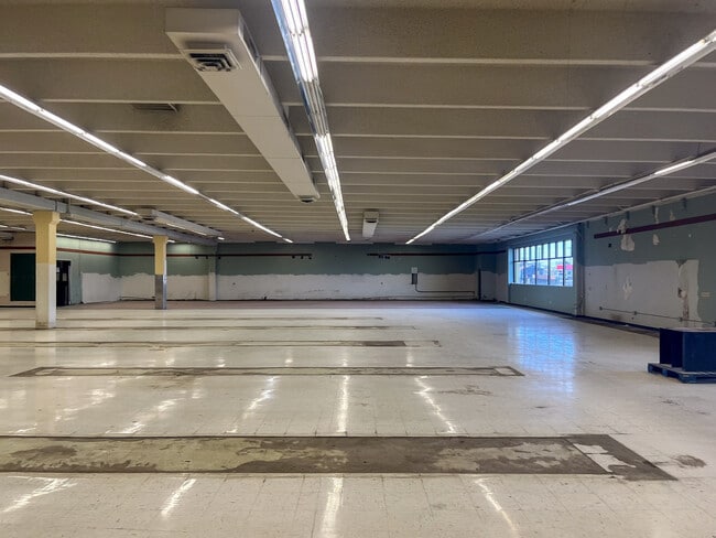
This Property Is For Sale
Current Lease Availabilities
NEARBY LISTINGS FOR SALE OR LEASE
Property Detail
12825 W 14Th Ave
15261.1907
Airway Hts
Storebuilding
AIRWAY HTS TR 1 OF BSP93-002 AUDITORS #9303240410 BK 1 PG 59
X
Spokane
53063C0525D
Washington
2025
4.94 AC
2025
West Plains
010401
Spokane
49,410 SF
Spokane-Spokane Valley, WA
DEMOGRAPHICS near 12825 W 14Th Ave
1 Mile
3 Mile
5 Mile
2024 Total Population
6,829
16,289
25,956
2029 Population
7,513
17,531
27,945
Pop Growth 2024-2029
+ 10.02%
+ 7.62%
+ 7.66%
Average Age
35
36
36
2024 Total Households
2,480
5,208
8,664
HH Growth 2024-2029
+ 9.88%
+ 8.06%
+ 8.00%
Median Household Inc
$61,279
$60,804
$65,127
Avg Household Size
2.70
2.60
2.60
2024 Avg HH Vehicles
2.00
2.00
2.00
Median Home Value
$277,864
$321,357
$351,100
Median Year Built
2009
2005
2003
Nearby Places
- Restaurants
- Banks
- Shops
- Fitness
- Groceries
PUBLIC TRANSPORTATION
COMMUTER RAIL
DRIVE
WALK
Distance
18 min
9.6 mi
AIRPORT
Spokane International
DRIVE
WALK
Distance
Spokane International
14 min
5.9 mi
Nearby Properties
Address
Land Use
TOTAL SIZE
Lot Size
Zoning
Address
Land Use
TOTAL SIZE
Lot Size
Zoning
884,262 SF
152.68 AC
PUBLIC
Address
Land Use
TOTAL SIZE
Lot Size
Zoning
1,180,186 SF
22.94 AC
TRIBAL
Address
Land Use
TOTAL SIZE
Lot Size
Zoning
534,093 SF
113 AC
TRIBAL
Address
Land Use
TOTAL SIZE
Lot Size
Zoning
375,237 SF
138.63 AC
TRIBAL
Address
Land Use
TOTAL SIZE
Lot Size
Zoning
118,996 SF
8.21 AC
LI
Address
Land Use
TOTAL SIZE
Lot Size
Zoning
274,308 SF
13 AC
R-3
Address
Land Use
TOTAL SIZE
Lot Size
Zoning
191,286 SF
10.81 AC
R-3
Address
Land Use
TOTAL SIZE
Lot Size
Zoning
218,400 SF
14.69 AC
Address
Land Use
TOTAL SIZE
Lot Size
Zoning
187,000 SF
12.43 AC
I-2
Address
Land Use
TOTAL SIZE
Lot Size
Zoning
314,707 SF
16 AC
LI
Address
Land Use
TOTAL SIZE
Lot Size
Zoning
122,949 SF
11.07 AC
LI
Address
Land Use
TOTAL SIZE
Lot Size
Zoning
147,774 SF
6.64 AC
RC
Address
Land Use
TOTAL SIZE
Lot Size
Zoning
149,942 SF
8.27 AC
R-3
Address
Land Use
TOTAL SIZE
Lot Size
Zoning
164,522 SF
19.37 AC
Address
Land Use
TOTAL SIZE
Lot Size
Zoning
59,171 SF
10.12 AC
Address
Land Use
TOTAL SIZE
Lot Size
Zoning
104,889 SF
21.60 AC
LI
Address
Land Use
TOTAL SIZE
Lot Size
Zoning
183,750 SF
21.40 AC
I-2
Address
Land Use
TOTAL SIZE
Lot Size
Zoning
387,963 SF
49.93 AC
LI
Address
Land Use
TOTAL SIZE
Lot Size
Zoning
46,520 SF
70 AC
I-1
Address
Land Use
TOTAL SIZE
Lot Size
Zoning
101,970 SF
7.88 AC
LI
Address
Land Use
TOTAL SIZE
Lot Size
Zoning
287,334 SF
39.24 AC
I-2
Address
Land Use
TOTAL SIZE
Lot Size
Zoning
152,130 SF
35.26 AC
I-2
Address
Land Use
TOTAL SIZE
Lot Size
Zoning
150,267 SF
8.13 AC
LI
Address
Land Use
TOTAL SIZE
Lot Size
Zoning
77,515 SF
4.70 AC
Address
Land Use
TOTAL SIZE
Lot Size
Zoning
86,361 SF
4.85 AC
R-3
Address
Land Use
TOTAL SIZE
Lot Size
Zoning
70,404 SF
61.69 AC
Address
Land Use
TOTAL SIZE
Lot Size
Zoning
51,074 SF
Address
Land Use
TOTAL SIZE
Lot Size
Zoning
41,340 SF
6.88 AC
Address
Land Use
TOTAL SIZE
Lot Size
Zoning
38,832 SF
6.75 AC
Address
Land Use
TOTAL SIZE
Lot Size
Zoning
67,500 SF
5.11 AC
The World's #1 Commercial Real Estate Marketplace
Connect with us
© 2025 CoStar Group
The information above has been obtained from sources believed reliable. While we do not doubt its accuracy we have not verified it and make no guarantee, warranty or representation about it. It is your responsibility to independently confirm its accuracy and completeness. Any projections, opinions, assumptions, or estimates used are for example only and do not represent the current or future performance of the property. The value of this transaction to you depends on tax and other factors which should be evaluated by your tax, financial, and legal advisors. You and your advisors should conduct a careful, independent investigation of the property to determine to your satisfaction the suitability of the property for your needs.