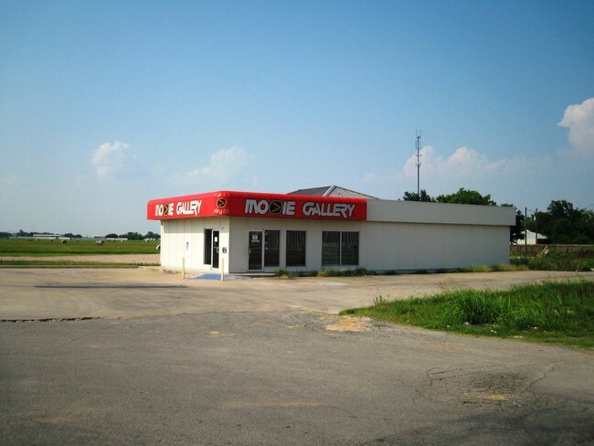
Property Record
12815 Highway 36, Needville, TX 77461
NEARBY LISTINGS FOR SALE OR LEASE
-
-
View all Needville listings for lease on LoopNet.com
Property Detail
12815 Highway 36
Houston-The Woodlands-Sugar Land, TX
Starnes/Nordt S/D Sec 1
7450-01-001-0060-906
STARNES/NORDT S/D SEC 1, BLOCK 1, LOT 4 - 5, ACRES 0.5654
Commercialnec
Fort Bend
X
Texas
48157C0400M
4-5
2024
0.55 AC
2025
Far New Territory
675600
Houston
2,680 SF
DEMOGRAPHICS near 12815 Highway 36
1 Mile
3 Mile
5 Mile
2024 Total Population
2,696
7,389
11,696
2029 Population
3,231
8,874
14,074
Pop Growth 2024-2029
+ 19.84%
+ 20.10%
+ 20.33%
Average Age
39
38
39
2024 Total Households
963
2,565
3,975
HH Growth 2024-2029
+ 20.46%
+ 20.74%
+ 20.93%
Median Household Inc
$68,109
$71,733
$69,408
Avg Household Size
2.80
2.90
2.90
2024 Avg HH Vehicles
2.00
2.00
2.00
Median Home Value
$212,621
$234,508
$249,632
Median Year Built
1984
1991
1992
Nearby Places
Map Layers
Map Styles
 Street
 Aerial
- Restaurants
- Banks
- Shops
- Fitness
- Groceries
SALE & LEASE HISTORY
LISTING DATE
SALE/LEASE

Sep 25, 2016
For Lease
Sep 24, 2016
For Sale
May 01, 2020
For Lease
Feb 12, 2020
For Sale
Feb 09, 2018
For Sale
Nearby Properties
Address
Land Use
TOTAL SIZE
Lot Size
Zoning
Address
Land Use
TOTAL SIZE
Lot Size
Zoning
113,567 SF
18 AC
Address
Land Use
TOTAL SIZE
Lot Size
Zoning
72,244 SF
17.68 AC
Address
Land Use
TOTAL SIZE
Lot Size
Zoning
3.74 AC
SY
Address
Land Use
TOTAL SIZE
Lot Size
Zoning
864 SF
80.11 AC
QYSN
Address
Land Use
TOTAL SIZE
Lot Size
Zoning
22,980 SF
7.65 AC
Address
Land Use
TOTAL SIZE
Lot Size
Zoning
18,870 SF
3 AC
O
Address
Land Use
TOTAL SIZE
Lot Size
Zoning
624 SF
156.97 AC
YOT
Address
Land Use
TOTAL SIZE
Lot Size
Zoning
7,093 SF
8.08 AC
Address
Land Use
TOTAL SIZE
Lot Size
Zoning
155.81 AC
Address
Land Use
TOTAL SIZE
Lot Size
Zoning
14,234 SF
10.18 AC
Y
Address
Land Use
TOTAL SIZE
Lot Size
Zoning
3,248 SF
89.86 AC
QOY
Address
Land Use
TOTAL SIZE
Lot Size
Zoning
17.59 AC
S
Address
Land Use
TOTAL SIZE
Lot Size
Zoning
1,176 SF
95.69 AC
YOQ
Address
Land Use
TOTAL SIZE
Lot Size
Zoning
1,304 SF
5.50 AC
Y
Address
Land Use
TOTAL SIZE
Lot Size
Zoning
20,053 SF
3.16 AC
Address
Land Use
TOTAL SIZE
Lot Size
Zoning
15,000 SF
1.38 AC
SHMY
Address
Land Use
TOTAL SIZE
Lot Size
Zoning
9,478 SF
3.83 AC
NS
Address
Land Use
TOTAL SIZE
Lot Size
Zoning
20,303 SF
4.72 AC
SY
Address
Land Use
TOTAL SIZE
Lot Size
Zoning
800 SF
100.51 AC
OY
Address
Land Use
TOTAL SIZE
Lot Size
Zoning
98 AC
OS
Address
Land Use
TOTAL SIZE
Lot Size
Zoning
5,862 SF
26.57 AC
Address
Land Use
TOTAL SIZE
Lot Size
Zoning
10,975 SF
1.16 AC
SHMY
Address
Land Use
TOTAL SIZE
Lot Size
Zoning
800 SF
6.77 AC
Address
Land Use
TOTAL SIZE
Lot Size
Zoning
1.91 AC
Address
Land Use
TOTAL SIZE
Lot Size
Zoning
9.17 AC
Address
Land Use
TOTAL SIZE
Lot Size
Zoning
6,848 SF
0.68 AC
Address
Land Use
TOTAL SIZE
Lot Size
Zoning
5,040 SF
1.96 AC
XY
Address
Land Use
TOTAL SIZE
Lot Size
Zoning
6,945 SF
18.39 AC
QS
Address
Land Use
TOTAL SIZE
Lot Size
Zoning
4,000 SF
10.74 AC
Address
Land Use
TOTAL SIZE
Lot Size
Zoning
6,212 SF
1.17 AC
X
The World's #1 Commercial Real Estate Marketplace
Connect with us
© 2025 CoStar Group
The information above has been obtained from sources believed reliable. While we do not doubt its accuracy we have not verified it and make no guarantee, warranty or representation about it. It is your responsibility to independently confirm its accuracy and completeness. Any projections, opinions, assumptions, or estimates used are for example only and do not represent the current or future performance of the property. The value of this transaction to you depends on tax and other factors which should be evaluated by your tax, financial, and legal advisors. You and your advisors should conduct a careful, independent investigation of the property to determine to your satisfaction the suitability of the property for your needs.