Property Record
12828 Highway 59, Splendora, TX 77372
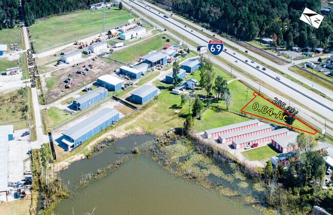


Property Detail
12828 Highway 59
Houston-Pasadena-The Woodlands, TX
A0080 - BLACKMAN JOSIAH, TRACT 1, ACRES 0.642
0080-00-00400
MONTGOMERY
Commercialnec
Texas
B and X Area of moderate flood hazard, usually the area between the limits of the 100-year and 500-year floods.
45,46
2024
0.89 AC
2025
Outlying Montgomery Cnty
692803
Houston
2,400 SF
NEARBY LISTINGS FOR SALE OR LEASE
DEMOGRAPHICS near 12828 Highway 59
1 mile
3 mile
5 mile
2025 Total Population
2,039
20,678
49,157
2030 Population
2,408
24,655
58,841
Pop Growth 2025-2030
+ 18.10%
+ 19.23%
+ 19.70%
Average Age
37
38
37
2025 Total Households
670
6,899
16,344
HH Growth 2025-2030
+ 18.81%
+ 19.80%
+ 20.30%
Median Household Inc
$89,347
$94,483
$82,316
Avg Household Size
3.00
3.00
3.00
2025 Avg HH Vehicles
2.00
2.00
2.00
Median Home Value
$254,999
$309,960
$299,796
Median Year Built
1996
2006
2007
Nearby Places
Map Layers
Map Styles
 Street
 Aerial
Layers
 Traffic
 Biking
Places
Listings with unknown addresses are not visible on the map
- Restaurants
- Banks
- Shops
- Fitness
- Groceries
PUBLIC TRANSPORTATION
AIRPORT
George Bush Intcntl/Houston
Drive
Walk
Distance
George Bush Intcntl/Houston
33 min
27.6 mi
Freight Ports
Port of Houston
Drive
Walk
Distance
Port of Houston
55 min
42.9 mi
SALE & LEASE HISTORY
LISTING DATE
SALE/LEASE

Oct 07, 2020
For Sale
Nearby Properties
Address
Land Use
TOTAL SIZE
Lot Size
Zoning
Address
Land Use
TOTAL SIZE
Lot Size
Zoning
84,249 SF
38.34 AC
Address
Land Use
TOTAL SIZE
Lot Size
Zoning
97,193 SF
24.79 AC
5
Address
Land Use
TOTAL SIZE
Lot Size
Zoning
78,721 SF
22.26 AC
Address
Land Use
TOTAL SIZE
Lot Size
Zoning
26,348 SF
30.22 AC
5
Address
Land Use
TOTAL SIZE
Lot Size
Zoning
84,704 SF
4.47 AC
5
Address
Land Use
TOTAL SIZE
Lot Size
Zoning
30,916 SF
3.36 AC
Address
Land Use
TOTAL SIZE
Lot Size
Zoning
40,592 SF
33.55 AC
Address
Land Use
TOTAL SIZE
Lot Size
Zoning
3,880 SF
13.32 AC
5
Address
Land Use
TOTAL SIZE
Lot Size
Zoning
32,600 SF
9.21 AC
5
Address
Land Use
TOTAL SIZE
Lot Size
Zoning
19,684 SF
7.90 AC
5
Address
Land Use
TOTAL SIZE
Lot Size
Zoning
12,634 SF
4.74 AC
Address
Land Use
TOTAL SIZE
Lot Size
Zoning
44,160 SF
10.98 AC
5
Address
Land Use
TOTAL SIZE
Lot Size
Zoning
58,972 SF
4.70 AC
5
Address
Land Use
TOTAL SIZE
Lot Size
Zoning
10,792 SF
2.70 AC
Address
Land Use
TOTAL SIZE
Lot Size
Zoning
237 SF
10.51 AC
5
Address
Land Use
TOTAL SIZE
Lot Size
Zoning
10,640 SF
1.13 AC
Address
Land Use
TOTAL SIZE
Lot Size
Zoning
7,000 SF
4.51 AC
Address
Land Use
TOTAL SIZE
Lot Size
Zoning
36,490 SF
2.72 AC
5
Address
Land Use
TOTAL SIZE
Lot Size
Zoning
17,158 SF
11.25 AC
Address
Land Use
TOTAL SIZE
Lot Size
Zoning
9,100 SF
1.71 AC
5
Address
Land Use
TOTAL SIZE
Lot Size
Zoning
23,990 SF
15 AC
5
Address
Land Use
TOTAL SIZE
Lot Size
Zoning
9,740 SF
8.08 AC
5
Address
Land Use
TOTAL SIZE
Lot Size
Zoning
5,279 SF
11.33 AC
5
Address
Land Use
TOTAL SIZE
Lot Size
Zoning
6,193 SF
4.84 AC
5
Address
Land Use
TOTAL SIZE
Lot Size
Zoning
31,430 SF
1.43 AC
Address
Land Use
TOTAL SIZE
Lot Size
Zoning
25,300 SF
5.13 AC
Address
Land Use
TOTAL SIZE
Lot Size
Zoning
9,100 SF
1.18 AC
5
Address
Land Use
TOTAL SIZE
Lot Size
Zoning
49.40 AC
5
Address
Land Use
TOTAL SIZE
Lot Size
Zoning
9,000 SF
1.93 AC
The World's #1 Commercial Real Estate Marketplace
Connect with us
© 2026 CoStar Group
The information above has been obtained from sources believed reliable. While we do not doubt its accuracy we have not verified it and make no guarantee, warranty or representation about it. It is your responsibility to independently confirm its accuracy and completeness. Any projections, opinions, assumptions, or estimates used are for example only and do not represent the current or future performance of the property. The value of this transaction to you depends on tax and other factors which should be evaluated by your tax, financial, and legal advisors. You and your advisors should conduct a careful, independent investigation of the property to determine to your satisfaction the suitability of the property for your needs.