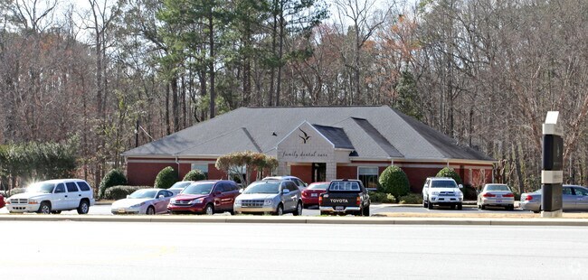
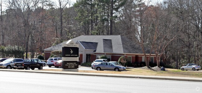
Property Record
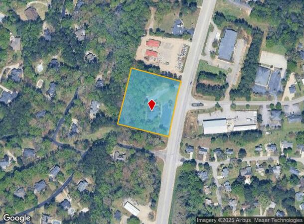
1283 N Lake Dr, Lexington, SC 29072
NEARBY LISTINGS FOR SALE OR LEASE
Property Detail
1283 N Lake Dr
003400-05-008
Prepared For Lindsay W Addy
Medicalbuilding
NONE
X
Lexington
45063C0138J
South Carolina
2025
2.88 AC
2024
Lexington
021049
Columbia
5,856 SF
Columbia, SC
DEMOGRAPHICS near 1283 N Lake Dr
1 Mile
3 Mile
5 Mile
2024 Total Population
5,749
32,297
79,725
2029 Population
6,212
35,162
86,786
Pop Growth 2024-2029
+ 8.05%
+ 8.87%
+ 8.86%
Average Age
39
41
41
2024 Total Households
2,188
12,608
31,453
HH Growth 2024-2029
+ 8.23%
+ 9.10%
+ 9.07%
Median Household Inc
$101,599
$85,232
$80,636
Avg Household Size
2.60
2.50
2.50
2024 Avg HH Vehicles
2.00
2.00
2.00
Median Home Value
$259,007
$264,238
$228,413
Median Year Built
1996
1999
1996
Nearby Places
Map Layers
Map Styles
 Street
 Aerial
- Restaurants
- Banks
- Shops
- Fitness
- Groceries
PUBLIC TRANSPORTATION
AIRPORT
Columbia Metro
DRIVE
WALK
Distance
Columbia Metro
31 min
15.8 mi
Freight Ports
North Charleston Terminal
DRIVE
WALK
Distance
North Charleston Terminal
131 min
112.1 mi
Nearby Properties
Address
Land Use
TOTAL SIZE
Lot Size
Zoning
Address
Land Use
TOTAL SIZE
Lot Size
Zoning
78,966 SF
10.34 AC
Address
Land Use
TOTAL SIZE
Lot Size
Zoning
37,794 SF
22.37 AC
ID
Address
Land Use
TOTAL SIZE
Lot Size
Zoning
4,198 SF
23.54 AC
Address
Land Use
TOTAL SIZE
Lot Size
Zoning
63,658 SF
17.56 AC
GC
Address
Land Use
TOTAL SIZE
Lot Size
Zoning
3,383 SF
20.65 AC
Address
Land Use
TOTAL SIZE
Lot Size
Zoning
38,496 SF
19.41 AC
HDR
Address
Land Use
TOTAL SIZE
Lot Size
Zoning
3,406 SF
19.99 AC
HDR
Address
Land Use
TOTAL SIZE
Lot Size
Zoning
204,927 SF
24.82 AC
GC
Address
Land Use
TOTAL SIZE
Lot Size
Zoning
78,131 SF
24 AC
GC
Address
Land Use
TOTAL SIZE
Lot Size
Zoning
86,935 SF
9.91 AC
ID
Address
Land Use
TOTAL SIZE
Lot Size
Zoning
64,281 SF
11.71 AC
GC
Address
Land Use
TOTAL SIZE
Lot Size
Zoning
79,246 SF
9.04 AC
GC
Address
Land Use
TOTAL SIZE
Lot Size
Zoning
3,079 SF
15.93 AC
HDR
Address
Land Use
TOTAL SIZE
Lot Size
Zoning
2,065 SF
19.73 AC
HDR
Address
Land Use
TOTAL SIZE
Lot Size
Zoning
85,600 SF
22.08 AC
Address
Land Use
TOTAL SIZE
Lot Size
Zoning
136,940 SF
20.36 AC
GC
Address
Land Use
TOTAL SIZE
Lot Size
Zoning
102,553 SF
13.30 AC
GC
Address
Land Use
TOTAL SIZE
Lot Size
Zoning
9,792 SF
7.47 AC
HDR
Address
Land Use
TOTAL SIZE
Lot Size
Zoning
127,329 SF
10.91 AC
Address
Land Use
TOTAL SIZE
Lot Size
Zoning
85,508 SF
9.22 AC
GC
Address
Land Use
TOTAL SIZE
Lot Size
Zoning
66,043 SF
2.70 AC
ID
Address
Land Use
TOTAL SIZE
Lot Size
Zoning
41,883 SF
21.77 AC
ID
Address
Land Use
TOTAL SIZE
Lot Size
Zoning
62,141 SF
7.28 AC
GC
Address
Land Use
TOTAL SIZE
Lot Size
Zoning
78,665 SF
7.58 AC
GC
Address
Land Use
TOTAL SIZE
Lot Size
Zoning
37,404 SF
9.32 AC
Address
Land Use
TOTAL SIZE
Lot Size
Zoning
51,657 SF
3.48 AC
ID
Address
Land Use
TOTAL SIZE
Lot Size
Zoning
33,218 SF
4.40 AC
GC
Address
Land Use
TOTAL SIZE
Lot Size
Zoning
15,343 SF
1.30 AC
GC
Address
Land Use
TOTAL SIZE
Lot Size
Zoning
14,820 SF
2.56 AC
Address
Land Use
TOTAL SIZE
Lot Size
Zoning
18,300 SF
3.33 AC
RD
The World's #1 Commercial Real Estate Marketplace
Connect with us
© 2025 CoStar Group
The information above has been obtained from sources believed reliable. While we do not doubt its accuracy we have not verified it and make no guarantee, warranty or representation about it. It is your responsibility to independently confirm its accuracy and completeness. Any projections, opinions, assumptions, or estimates used are for example only and do not represent the current or future performance of the property. The value of this transaction to you depends on tax and other factors which should be evaluated by your tax, financial, and legal advisors. You and your advisors should conduct a careful, independent investigation of the property to determine to your satisfaction the suitability of the property for your needs.