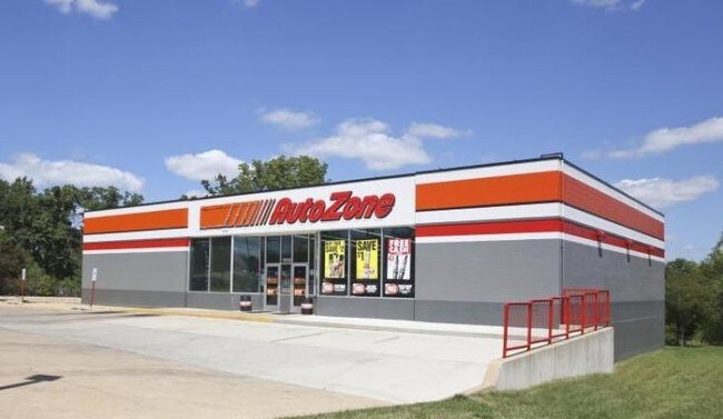
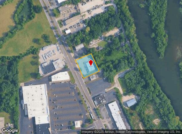
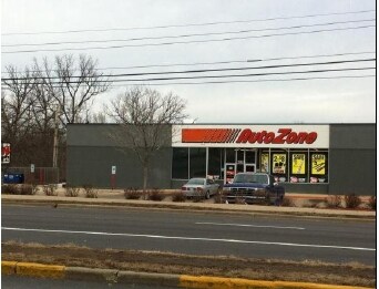
Property Record
1283 N Lake St, Aurora, IL 60506
NEARBY LISTINGS FOR SALE OR LEASE
Property Detail
1283 N Lake St
Chicago-Naperville-Elgin, IL-IN-WI
Andriopoulos Sub
15-10-352-053
ANDRIOPOULOS SUB LT 1
Commercialnec
Kane
X
Illinois
17089C0340H
1
2024
0.74 AC
2024
Western East/West Corr
852905
Chicago
DEMOGRAPHICS near 1283 N Lake St
1 Mile
3 Mile
5 Mile
2024 Total Population
9,184
109,119
207,519
2029 Population
9,229
108,676
207,110
Pop Growth 2024-2029
+ 0.49%
(0.41%)
(0.20%)
Average Age
37
37
38
2024 Total Households
3,019
36,365
71,200
HH Growth 2024-2029
+ 0.70%
(0.30%)
(0.16%)
Median Household Inc
$56,850
$70,375
$82,164
Avg Household Size
2.90
2.90
2.80
2024 Avg HH Vehicles
2.00
2.00
2.00
Median Home Value
$165,908
$200,093
$246,188
Median Year Built
1966
1967
1981
Nearby Places
Map Layers
Map Styles
 Street
 Aerial
- Restaurants
- Banks
- Shops
- Fitness
- Groceries
PUBLIC TRANSPORTATION
COMMUTER RAIL
Aurora Station (Burlington Northern-Santa Fe Railway Line - Northeast Illinois Regional Commuter Railroad (Metra))
DRIVE
WALK
Distance
Aurora Station (Burlington Northern-Santa Fe Railway Line - Northeast Illinois Regional Commuter Railroad (Metra))
6 min
2.5 mi
Route 59 Station (Burlington Northern-Santa Fe Railway Line - Northeast Illinois Regional Commuter Railroad (Metra))
DRIVE
WALK
Distance
Route 59 Station (Burlington Northern-Santa Fe Railway Line - Northeast Illinois Regional Commuter Railroad (Metra))
14 min
6.1 mi
AIRPORT
Chicago Midway International
DRIVE
WALK
Distance
Chicago Midway International
51 min
35.6 mi
Chicago O'Hare International
DRIVE
WALK
Distance
Chicago O'Hare International
50 min
36.5 mi
Freight Ports
Port Milwaukee
DRIVE
WALK
Distance
Port Milwaukee
132 min
108.2 mi
Nearby Properties
Address
Land Use
TOTAL SIZE
Lot Size
Zoning
Address
Land Use
TOTAL SIZE
Lot Size
Zoning
41.29 AC
Address
Land Use
TOTAL SIZE
Lot Size
Zoning
27.18 AC
Address
Land Use
TOTAL SIZE
Lot Size
Zoning
10.62 AC
Address
Land Use
TOTAL SIZE
Lot Size
Zoning
Address
Land Use
TOTAL SIZE
Lot Size
Zoning
530,523 SF
37.65 AC
Address
Land Use
TOTAL SIZE
Lot Size
Zoning
28.35 AC
Address
Land Use
TOTAL SIZE
Lot Size
Zoning
Address
Land Use
TOTAL SIZE
Lot Size
Zoning
18.48 AC
Address
Land Use
TOTAL SIZE
Lot Size
Zoning
Address
Land Use
TOTAL SIZE
Lot Size
Zoning
692,020 SF
33.90 AC
Address
Land Use
TOTAL SIZE
Lot Size
Zoning
394,560 SF
19.34 AC
Address
Land Use
TOTAL SIZE
Lot Size
Zoning
840,912 SF
49.56 AC
Address
Land Use
TOTAL SIZE
Lot Size
Zoning
Address
Land Use
TOTAL SIZE
Lot Size
Zoning
581,960 SF
17.63 AC
Address
Land Use
TOTAL SIZE
Lot Size
Zoning
20.56 AC
Address
Land Use
TOTAL SIZE
Lot Size
Zoning
12.80 AC
Address
Land Use
TOTAL SIZE
Lot Size
Zoning
622,072 SF
6.04 AC
Address
Land Use
TOTAL SIZE
Lot Size
Zoning
521,922 SF
19.87 AC
Address
Land Use
TOTAL SIZE
Lot Size
Zoning
8.22 AC
Address
Land Use
TOTAL SIZE
Lot Size
Zoning
Address
Land Use
TOTAL SIZE
Lot Size
Zoning
607,706 SF
16.55 AC
Address
Land Use
TOTAL SIZE
Lot Size
Zoning
25.07 AC
Address
Land Use
TOTAL SIZE
Lot Size
Zoning
11.79 AC
Address
Land Use
TOTAL SIZE
Lot Size
Zoning
255,500 SF
17.64 AC
Address
Land Use
TOTAL SIZE
Lot Size
Zoning
320,874 SF
1.49 AC
Address
Land Use
TOTAL SIZE
Lot Size
Zoning
Address
Land Use
TOTAL SIZE
Lot Size
Zoning
383,948 SF
17.92 AC
Address
Land Use
TOTAL SIZE
Lot Size
Zoning
17.42 AC
Address
Land Use
TOTAL SIZE
Lot Size
Zoning
224,624 SF
8.35 AC
Address
Land Use
TOTAL SIZE
Lot Size
Zoning
317,815 SF
21.29 AC
The World's #1 Commercial Real Estate Marketplace
Connect with us
© 2025 CoStar Group
The information above has been obtained from sources believed reliable. While we do not doubt its accuracy we have not verified it and make no guarantee, warranty or representation about it. It is your responsibility to independently confirm its accuracy and completeness. Any projections, opinions, assumptions, or estimates used are for example only and do not represent the current or future performance of the property. The value of this transaction to you depends on tax and other factors which should be evaluated by your tax, financial, and legal advisors. You and your advisors should conduct a careful, independent investigation of the property to determine to your satisfaction the suitability of the property for your needs.