Property Record
12831 Maclay St, Sylmar, CA 91342
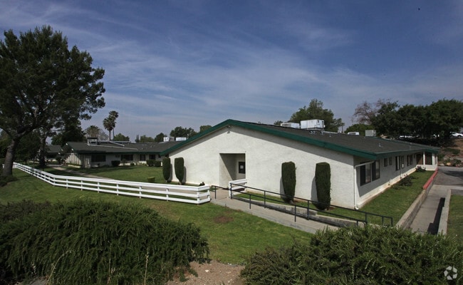

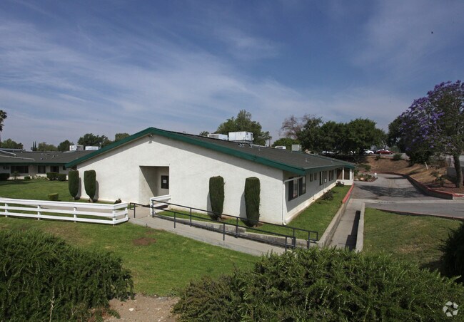
Property Detail
12831 Maclay St
2525-011-007
M R 37-5-16 FOR DESC SEE ASSESSORS MAPS POR OF BLK 21
Retirementnursinghomecombined
Los Angeles
LAA1
California
B and X Area of moderate flood hazard, usually the area between the limits of the 100-year and 500-year floods.
5.99 AC
2024
Eastern SFV
2025
Los Angeles
106112
Los Angeles-Long Beach-Glendale, CA
53,465 SF
NEARBY LISTINGS FOR SALE OR LEASE
-
-
View all Sylmar listings for sale on LoopNet.com
DEMOGRAPHICS near 12831 Maclay St
1 mile
3 mile
5 mile
2025 Total Population
12,742
142,039
261,100
2030 Population
12,550
139,596
256,661
Pop Growth 2025-2030
(1.51%)
(1.72%)
(1.70%)
Average Age
39
38
39
2025 Total Households
3,226
35,831
66,858
HH Growth 2025-2030
(1.70%)
(1.95%)
(1.92%)
Median Household Inc
$100,481
$84,748
$89,896
Avg Household Size
3.80
3.70
3.70
2025 Avg HH Vehicles
3.00
2.00
2.00
Median Home Value
$720,744
$694,587
$711,887
Median Year Built
1971
1968
1964
Nearby Places
Map Layers
Map Styles
 Street
 Aerial
Layers
 Traffic
 Biking
Places
Listings with unknown addresses are not visible on the map
- Restaurants
- Banks
- Shops
- Fitness
- Groceries
PUBLIC TRANSPORTATION
COMMUTER RAIL
Sylmar/San Fernando (Antelope Valley Line - Southern California Regional Rail Authority (Metrolink))
Drive
Walk
Distance
Sylmar/San Fernando (Antelope Valley Line - Southern California Regional Rail Authority (Metrolink))
6 min
3.1 mi
Sun Valley (Antelope Valley Line - Southern California Regional Rail Authority (Metrolink))
Drive
Walk
Distance
Sun Valley (Antelope Valley Line - Southern California Regional Rail Authority (Metrolink))
12 min
7.6 mi
AIRPORT
Bob Hope
Drive
Walk
Distance
Bob Hope
16 min
9.5 mi
Los Angeles International
Drive
Walk
Distance
Los Angeles International
41 min
30.7 mi
Freight Ports
Port of Long Beach
Drive
Walk
Distance
Port of Long Beach
62 min
50.0 mi
Nearby Properties
Address
Land Use
TOTAL SIZE
Lot Size
Zoning
Address
Land Use
TOTAL SIZE
Lot Size
Zoning
196,404 SF
10.06 AC
LARD1.5
Address
Land Use
TOTAL SIZE
Lot Size
Zoning
185,568 SF
9.06 AC
LARD1.5
Address
Land Use
TOTAL SIZE
Lot Size
Zoning
176,704 SF
4.10 AC
LAR3
Address
Land Use
TOTAL SIZE
Lot Size
Zoning
176,160 SF
3.19 AC
LAR3
Address
Land Use
TOTAL SIZE
Lot Size
Zoning
96,792 SF
5.52 AC
LARD2
Address
Land Use
TOTAL SIZE
Lot Size
Zoning
100,967 SF
11.78 AC
LAP
Address
Land Use
TOTAL SIZE
Lot Size
Zoning
105,541 SF
7.29 AC
LARA
Address
Land Use
TOTAL SIZE
Lot Size
Zoning
146,718 SF
7.36 AC
Address
Land Use
TOTAL SIZE
Lot Size
Zoning
146,718 SF
7.11 AC
SFM
Address
Land Use
TOTAL SIZE
Lot Size
Zoning
154,575 SF
12.20 AC
LAM3
Address
Land Use
TOTAL SIZE
Lot Size
Zoning
120,590 SF
9.52 AC
SFM2-C1P*
Address
Land Use
TOTAL SIZE
Lot Size
Zoning
108,012 SF
6.40 AC
LAR3
Address
Land Use
TOTAL SIZE
Lot Size
Zoning
140,411 SF
10.79 AC
LAM3
Address
Land Use
TOTAL SIZE
Lot Size
Zoning
44,480 SF
2.72 AC
LAM2
Address
Land Use
TOTAL SIZE
Lot Size
Zoning
99,966 SF
4.53 AC
LAM1
Address
Land Use
TOTAL SIZE
Lot Size
Zoning
110,096 SF
6.14 AC
LAM2
Address
Land Use
TOTAL SIZE
Lot Size
Zoning
138,229 SF
4.67 AC
SFM2*
Address
Land Use
TOTAL SIZE
Lot Size
Zoning
50,424 SF
3.32 AC
LAR3
Address
Land Use
TOTAL SIZE
Lot Size
Zoning
214,067 SF
8.50 AC
SFM2-C1P*
Address
Land Use
TOTAL SIZE
Lot Size
Zoning
86,301 SF
2.79 AC
LAR1
Address
Land Use
TOTAL SIZE
Lot Size
Zoning
58,260 SF
9.24 AC
LAC2
Address
Land Use
TOTAL SIZE
Lot Size
Zoning
88,000 SF
4.44 AC
LAM2
Address
Land Use
TOTAL SIZE
Lot Size
Zoning
93,030 SF
4.71 AC
Address
Land Use
TOTAL SIZE
Lot Size
Zoning
61,122 SF
2.85 AC
LAA2
Address
Land Use
TOTAL SIZE
Lot Size
Zoning
302,066 SF
8.77 AC
LAC2
Address
Land Use
TOTAL SIZE
Lot Size
Zoning
190,062 SF
8.70 AC
SFM1
Address
Land Use
TOTAL SIZE
Lot Size
Zoning
79,767 SF
2.56 AC
LAC2
Address
Land Use
TOTAL SIZE
Lot Size
Zoning
67,769 SF
1.30 AC
LARD3
The World's #1 Commercial Real Estate Marketplace
Connect with us
© 2026 CoStar Group
The information above has been obtained from sources believed reliable. While we do not doubt its accuracy we have not verified it and make no guarantee, warranty or representation about it. It is your responsibility to independently confirm its accuracy and completeness. Any projections, opinions, assumptions, or estimates used are for example only and do not represent the current or future performance of the property. The value of this transaction to you depends on tax and other factors which should be evaluated by your tax, financial, and legal advisors. You and your advisors should conduct a careful, independent investigation of the property to determine to your satisfaction the suitability of the property for your needs.