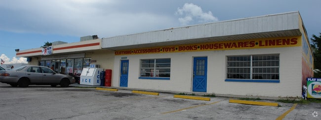
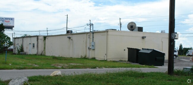
Property Record
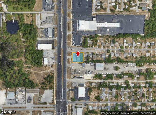
12838 Us Highway 19, Hudson, FL 34667
NEARBY LISTINGS FOR SALE OR LEASE
Property Detail
12838 Us Highway 19
Tampa-St. Petersburg-Clearwater, FL
Country Club Estates
03-25-16-0050-00000-0270
COUNTRY CLUB ESTATES UNIT 1-A PB 8 PG 105 LOT 27 OR 5482 PG 575
Storebuilding
Pasco
X
Florida
12101C0177G
27
2024
0.43 AC
2025
Pasco County
031101
Tampa/St Petersburg
3,712 SF
DEMOGRAPHICS near 12838 Us Highway 19
1 Mile
3 Mile
5 Mile
2024 Total Population
8,208
52,701
95,910
2029 Population
9,981
63,403
115,106
Pop Growth 2024-2029
+ 21.60%
+ 20.31%
+ 20.01%
Average Age
52
49
46
2024 Total Households
3,885
24,138
41,967
HH Growth 2024-2029
+ 21.70%
+ 20.37%
+ 20.05%
Median Household Inc
$44,423
$43,972
$43,957
Avg Household Size
2.00
2.10
2.20
2024 Avg HH Vehicles
2.00
1.00
2.00
Median Home Value
$163,930
$150,955
$154,109
Median Year Built
1977
1979
1980
Nearby Places
Map Layers
Map Styles
 Street
 Aerial
- Restaurants
- Banks
- Shops
- Fitness
- Groceries
PUBLIC TRANSPORTATION
AIRPORT
St Pete-Clearwater International
DRIVE
WALK
Distance
St Pete-Clearwater International
63 min
37.1 mi
Tampa International
DRIVE
WALK
Distance
Tampa International
57 min
40.1 mi
Freight Ports
Port of Tampa Bay
DRIVE
WALK
Distance
Port of Tampa Bay
70 min
43.7 mi
Nearby Properties
Address
Land Use
TOTAL SIZE
Lot Size
Zoning
Address
Land Use
TOTAL SIZE
Lot Size
Zoning
250,601 SF
38.64 AC
C2
Address
Land Use
TOTAL SIZE
Lot Size
Zoning
414,111 SF
23.78 AC
C1
Address
Land Use
TOTAL SIZE
Lot Size
Zoning
218,736 SF
39.17 AC
R1
Address
Land Use
TOTAL SIZE
Lot Size
Zoning
124,316 SF
22.91 AC
MF1
Address
Land Use
TOTAL SIZE
Lot Size
Zoning
124,470 SF
5.09 AC
C2
Address
Land Use
TOTAL SIZE
Lot Size
Zoning
189,166 SF
18.19 AC
C2
Address
Land Use
TOTAL SIZE
Lot Size
Zoning
106,741 SF
27.67 AC
MF1
Address
Land Use
TOTAL SIZE
Lot Size
Zoning
217,758 SF
34.95 AC
C2
Address
Land Use
TOTAL SIZE
Lot Size
Zoning
190,794 SF
10.88 AC
C2
Address
Land Use
TOTAL SIZE
Lot Size
Zoning
86,570 SF
8.06 AC
MF1
Address
Land Use
TOTAL SIZE
Lot Size
Zoning
111,060 SF
9.31 AC
C3
Address
Land Use
TOTAL SIZE
Lot Size
Zoning
75,205 SF
12.71 AC
PUD
Address
Land Use
TOTAL SIZE
Lot Size
Zoning
81,839 SF
3.33 AC
C2
Address
Land Use
TOTAL SIZE
Lot Size
Zoning
48,470 SF
4.19 AC
MPUD
Address
Land Use
TOTAL SIZE
Lot Size
Zoning
90,113 SF
8.22 AC
C2
Address
Land Use
TOTAL SIZE
Lot Size
Zoning
83,363 SF
5.97 AC
C2
Address
Land Use
TOTAL SIZE
Lot Size
Zoning
38,187 SF
6.48 AC
MPUD
Address
Land Use
TOTAL SIZE
Lot Size
Zoning
80,025 SF
10.55 AC
MF2
Address
Land Use
TOTAL SIZE
Lot Size
Zoning
52,704 SF
5 AC
MF2
Address
Land Use
TOTAL SIZE
Lot Size
Zoning
107,560 SF
5.96 AC
C2
Address
Land Use
TOTAL SIZE
Lot Size
Zoning
171,441 SF
8.70 AC
MF2
Address
Land Use
TOTAL SIZE
Lot Size
Zoning
188,871 SF
8.44 AC
C1
Address
Land Use
TOTAL SIZE
Lot Size
Zoning
49,118 SF
7.72 AC
C2
Address
Land Use
TOTAL SIZE
Lot Size
Zoning
70,005 SF
5.28 AC
C2
Address
Land Use
TOTAL SIZE
Lot Size
Zoning
83,135 SF
4.49 AC
MF2
Address
Land Use
TOTAL SIZE
Lot Size
Zoning
48,098 SF
2.52 AC
C2
Address
Land Use
TOTAL SIZE
Lot Size
Zoning
106,354 SF
8.69 AC
C2
Address
Land Use
TOTAL SIZE
Lot Size
Zoning
94,431 SF
10.79 AC
C2
Address
Land Use
TOTAL SIZE
Lot Size
Zoning
29,752 SF
12.61 AC
C2
Address
Land Use
TOTAL SIZE
Lot Size
Zoning
224,941 SF
23.03 AC
C2
The World's #1 Commercial Real Estate Marketplace
Connect with us
© 2025 CoStar Group
The information above has been obtained from sources believed reliable. While we do not doubt its accuracy we have not verified it and make no guarantee, warranty or representation about it. It is your responsibility to independently confirm its accuracy and completeness. Any projections, opinions, assumptions, or estimates used are for example only and do not represent the current or future performance of the property. The value of this transaction to you depends on tax and other factors which should be evaluated by your tax, financial, and legal advisors. You and your advisors should conduct a careful, independent investigation of the property to determine to your satisfaction the suitability of the property for your needs.