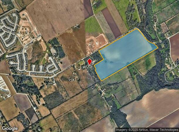
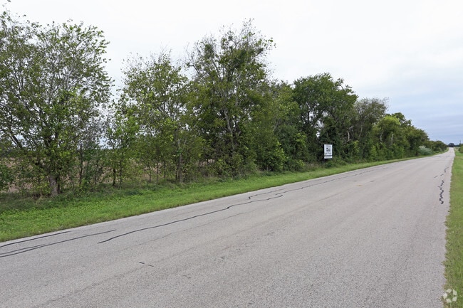
Property Record
12840 Lower Seguin Rd, Schertz, TX 78154

NEARBY LISTINGS FOR SALE OR LEASE
Property Detail
12840 Lower Seguin Rd
San Antonio-New Braunfels, TX
Conv A/S Code
05059-000-0099
CB 5059 P-9 (47.71 AC), P-9A (18.1 AC ) ABS 187 & CB 5066 P-2 (9.155 AC) A 609 2022-SPLIT PER DEED 20210100459
Privatepreserveopenspacevacantlandforestlandconservation
Bexar
AE
Texas
48029C0315F
99
2024
74.97 AC
2025
Northeast
131601
San Antonio
DEMOGRAPHICS near 12840 Lower Seguin Rd
1 Mile
3 Mile
5 Mile
2024 Total Population
898
10,922
75,720
2029 Population
974
12,237
84,529
Pop Growth 2024-2029
+ 8.46%
+ 12.04%
+ 11.63%
Average Age
37
39
38
2024 Total Households
312
3,976
26,129
HH Growth 2024-2029
+ 8.97%
+ 12.55%
+ 11.86%
Median Household Inc
$69,999
$74,606
$90,784
Avg Household Size
2.80
2.70
2.90
2024 Avg HH Vehicles
2.00
2.00
2.00
Median Home Value
$298,900
$299,124
$253,531
Median Year Built
1991
1998
2002
Nearby Places
Map Layers
Map Styles
 Street
 Aerial
- Restaurants
- Banks
- Shops
- Fitness
- Groceries
PUBLIC TRANSPORTATION
AIRPORT
San Antonio International
DRIVE
WALK
Distance
San Antonio International
30 min
18.2 mi
Freight Ports
Calhoun Port
DRIVE
WALK
Distance
Calhoun Port
174 min
140.6 mi
Nearby Properties
Address
Land Use
TOTAL SIZE
Lot Size
Zoning
Address
Land Use
TOTAL SIZE
Lot Size
Zoning
398,442 SF
14.62 AC
Address
Land Use
TOTAL SIZE
Lot Size
Zoning
33,243 SF
80.72 AC
Address
Land Use
TOTAL SIZE
Lot Size
Zoning
124,618 SF
8.59 AC
Address
Land Use
TOTAL SIZE
Lot Size
Zoning
160,400 SF
22.35 AC
Address
Land Use
TOTAL SIZE
Lot Size
Zoning
1,332 SF
70.85 AC
Address
Land Use
TOTAL SIZE
Lot Size
Zoning
2,574 SF
127.70 AC
Address
Land Use
TOTAL SIZE
Lot Size
Zoning
24,801 SF
17.64 AC
Address
Land Use
TOTAL SIZE
Lot Size
Zoning
74,210 SF
34.98 AC
Address
Land Use
TOTAL SIZE
Lot Size
Zoning
46,500 SF
3.01 AC
Address
Land Use
TOTAL SIZE
Lot Size
Zoning
1,036 SF
165.64 AC
Address
Land Use
TOTAL SIZE
Lot Size
Zoning
167.75 AC
Address
Land Use
TOTAL SIZE
Lot Size
Zoning
65,138 SF
13.69 AC
Address
Land Use
TOTAL SIZE
Lot Size
Zoning
36.29 AC
Address
Land Use
TOTAL SIZE
Lot Size
Zoning
47,601 SF
5.76 AC
Address
Land Use
TOTAL SIZE
Lot Size
Zoning
21,657 SF
3.12 AC
Address
Land Use
TOTAL SIZE
Lot Size
Zoning
47,923 SF
11.19 AC
Address
Land Use
TOTAL SIZE
Lot Size
Zoning
49,040 SF
6.67 AC
Address
Land Use
TOTAL SIZE
Lot Size
Zoning
736 SF
34.82 AC
Address
Land Use
TOTAL SIZE
Lot Size
Zoning
56,265 SF
4.67 AC
Address
Land Use
TOTAL SIZE
Lot Size
Zoning
65,556 SF
4.78 AC
Address
Land Use
TOTAL SIZE
Lot Size
Zoning
1,246 SF
218.03 AC
Address
Land Use
TOTAL SIZE
Lot Size
Zoning
1,292 SF
112.47 AC
Address
Land Use
TOTAL SIZE
Lot Size
Zoning
4,120 SF
83.68 AC
Address
Land Use
TOTAL SIZE
Lot Size
Zoning
142,016 SF
16.35 AC
Address
Land Use
TOTAL SIZE
Lot Size
Zoning
85,654 SF
21.64 AC
Address
Land Use
TOTAL SIZE
Lot Size
Zoning
52,589 SF
6.85 AC
Address
Land Use
TOTAL SIZE
Lot Size
Zoning
33,000 SF
2.53 AC
Address
Land Use
TOTAL SIZE
Lot Size
Zoning
25.84 AC
Address
Land Use
TOTAL SIZE
Lot Size
Zoning
189.56 AC
The World's #1 Commercial Real Estate Marketplace
Connect with us
© 2026 CoStar Group
The information above has been obtained from sources believed reliable. While we do not doubt its accuracy we have not verified it and make no guarantee, warranty or representation about it. It is your responsibility to independently confirm its accuracy and completeness. Any projections, opinions, assumptions, or estimates used are for example only and do not represent the current or future performance of the property. The value of this transaction to you depends on tax and other factors which should be evaluated by your tax, financial, and legal advisors. You and your advisors should conduct a careful, independent investigation of the property to determine to your satisfaction the suitability of the property for your needs.