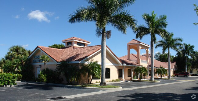
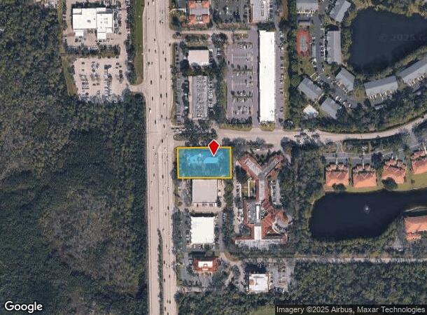
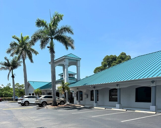
Property Record
12840 Tamiami Trl N, Naples, FL 34110
NEARBY LISTINGS FOR SALE OR LEASE
Property Detail
12840 Tamiami Trl N
Naples-Immokalee-Marco Island, FL
Imperial Southeast Land Trust
51580000100
IMPERIAL SOUTHEAST LAND TRUST LOT 2 OR 1864 PG 1785
Officebuilding
Collier
AE
Florida
12021C0191J
2
2024
0.96 AC
2025
North Naples
010108
Southwest Florida
8,281 SF
DEMOGRAPHICS near 12840 Tamiami Trl N
1 Mile
3 Mile
5 Mile
2024 Total Population
4,640
46,700
114,353
2029 Population
5,297
53,969
133,103
Pop Growth 2024-2029
+ 14.16%
+ 15.57%
+ 16.40%
Average Age
59
55
54
2024 Total Households
2,377
22,105
53,111
HH Growth 2024-2029
+ 13.84%
+ 15.42%
+ 16.04%
Median Household Inc
$66,847
$84,468
$82,268
Avg Household Size
1.90
2.00
2.00
2024 Avg HH Vehicles
2.00
2.00
2.00
Median Home Value
$348,501
$501,938
$476,708
Median Year Built
1991
1994
1995
Nearby Places
- Restaurants
- Banks
- Shops
- Fitness
- Groceries
PUBLIC TRANSPORTATION
AIRPORT
Southwest Florida International
DRIVE
WALK
Distance
Southwest Florida International
35 min
25.2 mi
Freight Ports
Port Manatee
DRIVE
WALK
Distance
Port Manatee
143 min
125.0 mi
SALE & LEASE HISTORY
LISTING DATE
SALE/LEASE

Sep 08, 2017
For Lease
Sep 05, 2017
For Sale
Feb 27, 2019
For Lease
Aug 29, 2024
For Lease
Nearby Properties
Address
Land Use
TOTAL SIZE
Lot Size
Zoning
Address
Land Use
TOTAL SIZE
Lot Size
Zoning
770,104 SF
26.22 AC
PUD
Address
Land Use
TOTAL SIZE
Lot Size
Zoning
993,493 SF
86.10 AC
PUD
Address
Land Use
TOTAL SIZE
Lot Size
Zoning
735,070 SF
41.34 AC
A
Address
Land Use
TOTAL SIZE
Lot Size
Zoning
377,883 SF
20.34 AC
PUD
Address
Land Use
TOTAL SIZE
Lot Size
Zoning
906,730 SF
7.86 AC
Address
Land Use
TOTAL SIZE
Lot Size
Zoning
313,544 SF
60 AC
A
Address
Land Use
TOTAL SIZE
Lot Size
Zoning
325,993 SF
35.92 AC
A
Address
Land Use
TOTAL SIZE
Lot Size
Zoning
331,056 SF
8 AC
CPD
Address
Land Use
TOTAL SIZE
Lot Size
Zoning
252,506 SF
36.27 AC
PUD
Address
Land Use
TOTAL SIZE
Lot Size
Zoning
87,499 SF
4.36 AC
Address
Land Use
TOTAL SIZE
Lot Size
Zoning
435,724 SF
64.61 AC
PUD
Address
Land Use
TOTAL SIZE
Lot Size
Zoning
10,831 SF
155 AC
RMF-16
Address
Land Use
TOTAL SIZE
Lot Size
Zoning
174,770 SF
3.65 AC
PUD
Address
Land Use
TOTAL SIZE
Lot Size
Zoning
227,264 SF
8.72 AC
A
Address
Land Use
TOTAL SIZE
Lot Size
Zoning
363,194 SF
2.51 AC
A
Address
Land Use
TOTAL SIZE
Lot Size
Zoning
181,774 SF
6.19 AC
PUD
Address
Land Use
TOTAL SIZE
Lot Size
Zoning
155,918 SF
27.31 AC
PUD
Address
Land Use
TOTAL SIZE
Lot Size
Zoning
174,365 SF
18.56 AC
PUD
Address
Land Use
TOTAL SIZE
Lot Size
Zoning
366,884 SF
30.65 AC
RM-2
Address
Land Use
TOTAL SIZE
Lot Size
Zoning
206,687 SF
19.85 AC
PUD
Address
Land Use
TOTAL SIZE
Lot Size
Zoning
128,681 SF
49.55 AC
A
Address
Land Use
TOTAL SIZE
Lot Size
Zoning
139,947 SF
4.99 AC
PUD
Address
Land Use
TOTAL SIZE
Lot Size
Zoning
253,108 SF
32.47 AC
PUD
Address
Land Use
TOTAL SIZE
Lot Size
Zoning
230,920 SF
7.80 AC
C-4
Address
Land Use
TOTAL SIZE
Lot Size
Zoning
112,623 SF
13.10 AC
PUD
Address
Land Use
TOTAL SIZE
Lot Size
Zoning
4.95 AC
C-3
Address
Land Use
TOTAL SIZE
Lot Size
Zoning
161,531 SF
18.72 AC
PUD
Address
Land Use
TOTAL SIZE
Lot Size
Zoning
106,929 SF
23.05 AC
A
Address
Land Use
TOTAL SIZE
Lot Size
Zoning
57,867 SF
60.86 AC
PUD
Address
Land Use
TOTAL SIZE
Lot Size
Zoning
182,802 SF
18.08 AC
CC
The World's #1 Commercial Real Estate Marketplace
Connect with us
© 2025 CoStar Group
The information above has been obtained from sources believed reliable. While we do not doubt its accuracy we have not verified it and make no guarantee, warranty or representation about it. It is your responsibility to independently confirm its accuracy and completeness. Any projections, opinions, assumptions, or estimates used are for example only and do not represent the current or future performance of the property. The value of this transaction to you depends on tax and other factors which should be evaluated by your tax, financial, and legal advisors. You and your advisors should conduct a careful, independent investigation of the property to determine to your satisfaction the suitability of the property for your needs.