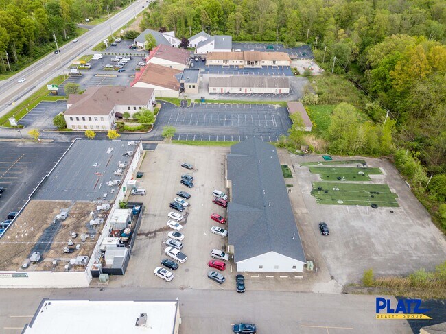
Property Record
1285 Boardman Canfield Rd, Youngstown, OH 44512


Current Lease Availabilities
NEARBY LISTINGS FOR SALE OR LEASE
Property Detail
1285 Boardman Canfield Rd
Youngstown/Warren/Boardman
Huntington Commercial Pl
Youngstown-Warren-Boardman, OH-PA
LOT 15 25 X 534.72 IRR HUNTINGTON COMMERCIAL PL
29-115-0-072.12-0
Mahoning
Officebuilding
Ohio
2024
15
2024
1.37 AC
812002
Mahoning County
9,000 SF
DEMOGRAPHICS near 1285 Boardman Canfield Rd
1 Mile
3 Mile
5 Mile
2024 Total Population
5,332
36,895
101,946
2029 Population
5,199
35,985
100,082
Pop Growth 2024-2029
(2.49%)
(2.47%)
(1.83%)
Average Age
45
44
43
2024 Total Households
2,512
16,677
44,861
HH Growth 2024-2029
(2.47%)
(2.53%)
(1.93%)
Median Household Inc
$69,336
$65,671
$55,157
Avg Household Size
2.10
2.20
2.20
2024 Avg HH Vehicles
2.00
2.00
2.00
Median Home Value
$222,138
$171,812
$143,325
Median Year Built
1982
1970
1963
Nearby Places
Map Layers
Map Styles
 Street
 Aerial
- Restaurants
- Banks
- Shops
- Fitness
- Groceries
Nearby Properties
Address
Land Use
TOTAL SIZE
Lot Size
Zoning
Address
Land Use
TOTAL SIZE
Lot Size
Zoning
252,909 SF
22.37 AC
C
Address
Land Use
TOTAL SIZE
Lot Size
Zoning
436,605 SF
64.24 AC
C
Address
Land Use
TOTAL SIZE
Lot Size
Zoning
318,339 SF
14.66 AC
R1
Address
Land Use
TOTAL SIZE
Lot Size
Zoning
Address
Land Use
TOTAL SIZE
Lot Size
Zoning
88,996 SF
10.94 AC
C
Address
Land Use
TOTAL SIZE
Lot Size
Zoning
47,538 SF
16.14 AC
C
Address
Land Use
TOTAL SIZE
Lot Size
Zoning
41,443 SF
0.93 AC
C
Address
Land Use
TOTAL SIZE
Lot Size
Zoning
57,178 SF
20.42 AC
R2
Address
Land Use
TOTAL SIZE
Lot Size
Zoning
100,565 SF
15.03 AC
R3
Address
Land Use
TOTAL SIZE
Lot Size
Zoning
Address
Land Use
TOTAL SIZE
Lot Size
Zoning
61,141 SF
1.01 AC
C
Address
Land Use
TOTAL SIZE
Lot Size
Zoning
41,835 SF
7.46 AC
I
Address
Land Use
TOTAL SIZE
Lot Size
Zoning
2.10 AC
Address
Land Use
TOTAL SIZE
Lot Size
Zoning
106,276 SF
10.86 AC
Address
Land Use
TOTAL SIZE
Lot Size
Zoning
332.96 AC
A
Address
Land Use
TOTAL SIZE
Lot Size
Zoning
23,583 SF
9.76 AC
C
Address
Land Use
TOTAL SIZE
Lot Size
Zoning
69,651 SF
2.82 AC
Address
Land Use
TOTAL SIZE
Lot Size
Zoning
51,967 SF
10.60 AC
C
Address
Land Use
TOTAL SIZE
Lot Size
Zoning
59,999 SF
6.07 AC
B
Address
Land Use
TOTAL SIZE
Lot Size
Zoning
102,699 SF
39.18 AC
R1
Address
Land Use
TOTAL SIZE
Lot Size
Zoning
60,854 SF
12.28 AC
R1
Address
Land Use
TOTAL SIZE
Lot Size
Zoning
91,900 SF
7.60 AC
C
Address
Land Use
TOTAL SIZE
Lot Size
Zoning
61,506 SF
9.51 AC
C
Address
Land Use
TOTAL SIZE
Lot Size
Zoning
142,279 SF
19.33 AC
R1
Address
Land Use
TOTAL SIZE
Lot Size
Zoning
31,512 SF
5.25 AC
R3
Address
Land Use
TOTAL SIZE
Lot Size
Zoning
52,876 SF
30.60 AC
MFR
Address
Land Use
TOTAL SIZE
Lot Size
Zoning
56,432 SF
8.42 AC
B3
Address
Land Use
TOTAL SIZE
Lot Size
Zoning
55,042 SF
5.72 AC
C
Address
Land Use
TOTAL SIZE
Lot Size
Zoning
115,719 SF
8.70 AC
I
Address
Land Use
TOTAL SIZE
Lot Size
Zoning
62,010 SF
5.02 AC
R3
The World's #1 Commercial Real Estate Marketplace
Connect with us
© 2025 CoStar Group
The information above has been obtained from sources believed reliable. While we do not doubt its accuracy we have not verified it and make no guarantee, warranty or representation about it. It is your responsibility to independently confirm its accuracy and completeness. Any projections, opinions, assumptions, or estimates used are for example only and do not represent the current or future performance of the property. The value of this transaction to you depends on tax and other factors which should be evaluated by your tax, financial, and legal advisors. You and your advisors should conduct a careful, independent investigation of the property to determine to your satisfaction the suitability of the property for your needs.