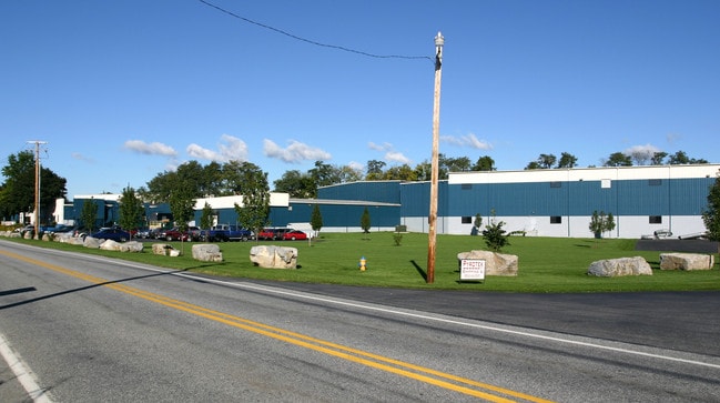
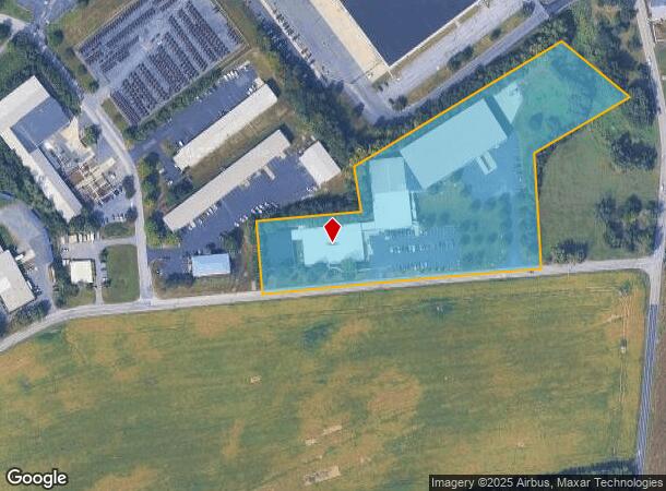
Property Record
1285 Claremont Rd, Carlisle, PA 17015
NEARBY LISTINGS FOR SALE OR LEASE
Property Detail
1285 Claremont Rd
Harrisburg-Carlisle, PA
LOTS 31 & 32A PB 83 PG 46
21-07-0465-031
Cumberland
Processingplant
Pennsylvania
X
31,32a
42041C0232F
6.66 AC
2025
Harrisburg Area West
2025
Philadelphia
011803
DEMOGRAPHICS near 1285 Claremont Rd
1 Mile
3 Mile
5 Mile
2024 Total Population
505
14,916
57,278
2029 Population
538
15,938
61,457
Pop Growth 2024-2029
+ 6.53%
+ 6.85%
+ 7.30%
Average Age
44
42
41
2024 Total Households
184
5,856
22,905
HH Growth 2024-2029
+ 6.52%
+ 7.10%
+ 7.47%
Median Household Inc
$75,595
$73,249
$74,499
Avg Household Size
2.50
2.40
2.30
2024 Avg HH Vehicles
2.00
2.00
2.00
Median Home Value
$409,091
$205,963
$236,528
Median Year Built
1988
1980
1975
Nearby Places
Map Layers
Map Styles
 Street
 Aerial
- Restaurants
- Banks
- Shops
- Fitness
- Groceries
PUBLIC TRANSPORTATION
AIRPORT
Harrisburg International
DRIVE
WALK
Distance
Harrisburg International
38 min
28.0 mi
Freight Ports
Port of Baltimore
DRIVE
WALK
Distance
Port of Baltimore
125 min
87.5 mi
Nearby Properties
Address
Land Use
TOTAL SIZE
Lot Size
Zoning
Address
Land Use
TOTAL SIZE
Lot Size
Zoning
213.18 AC
Address
Land Use
TOTAL SIZE
Lot Size
Zoning
61.58 AC
Address
Land Use
TOTAL SIZE
Lot Size
Zoning
56.28 AC
Address
Land Use
TOTAL SIZE
Lot Size
Zoning
67.20 AC
Address
Land Use
TOTAL SIZE
Lot Size
Zoning
35.80 AC
Address
Land Use
TOTAL SIZE
Lot Size
Zoning
55.72 AC
Address
Land Use
TOTAL SIZE
Lot Size
Zoning
36.15 AC
Address
Land Use
TOTAL SIZE
Lot Size
Zoning
36.54 AC
Address
Land Use
TOTAL SIZE
Lot Size
Zoning
48.31 AC
Address
Land Use
TOTAL SIZE
Lot Size
Zoning
33.84 AC
Address
Land Use
TOTAL SIZE
Lot Size
Zoning
38.73 AC
Address
Land Use
TOTAL SIZE
Lot Size
Zoning
18.01 AC
Address
Land Use
TOTAL SIZE
Lot Size
Zoning
113.58 AC
Address
Land Use
TOTAL SIZE
Lot Size
Zoning
9.99 AC
Address
Land Use
TOTAL SIZE
Lot Size
Zoning
Address
Land Use
TOTAL SIZE
Lot Size
Zoning
Address
Land Use
TOTAL SIZE
Lot Size
Zoning
58.56 AC
Address
Land Use
TOTAL SIZE
Lot Size
Zoning
120.28 AC
Address
Land Use
TOTAL SIZE
Lot Size
Zoning
40.39 AC
Address
Land Use
TOTAL SIZE
Lot Size
Zoning
7.67 AC
Address
Land Use
TOTAL SIZE
Lot Size
Zoning
Address
Land Use
TOTAL SIZE
Lot Size
Zoning
15.20 AC
Address
Land Use
TOTAL SIZE
Lot Size
Zoning
26.53 AC
Address
Land Use
TOTAL SIZE
Lot Size
Zoning
17.24 AC
Address
Land Use
TOTAL SIZE
Lot Size
Zoning
13.88 AC
Address
Land Use
TOTAL SIZE
Lot Size
Zoning
10.17 AC
Address
Land Use
TOTAL SIZE
Lot Size
Zoning
7.39 AC
Address
Land Use
TOTAL SIZE
Lot Size
Zoning
24.97 AC
Address
Land Use
TOTAL SIZE
Lot Size
Zoning
3.25 AC
Address
Land Use
TOTAL SIZE
Lot Size
Zoning
10.33 AC
The World's #1 Commercial Real Estate Marketplace
Connect with us
© 2025 CoStar Group
The information above has been obtained from sources believed reliable. While we do not doubt its accuracy we have not verified it and make no guarantee, warranty or representation about it. It is your responsibility to independently confirm its accuracy and completeness. Any projections, opinions, assumptions, or estimates used are for example only and do not represent the current or future performance of the property. The value of this transaction to you depends on tax and other factors which should be evaluated by your tax, financial, and legal advisors. You and your advisors should conduct a careful, independent investigation of the property to determine to your satisfaction the suitability of the property for your needs.