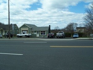
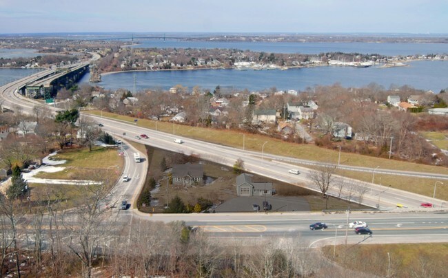
Property Record
1285 Main Rd, Tiverton, RI 02878

NEARBY LISTINGS FOR SALE OR LEASE
-
-
View all Tiverton listings for sale on LoopNet.com
Property Detail
1285 Main Rd
TIVE-000302-000000-000275
Newport
Commercialofficeresidentialmixeduse
Rhode Island
X
0.84 AC
44005C0039J
Newport County
2025
Providence
2025
Providence-Warwick, RI-MA
041602
DEMOGRAPHICS near 1285 Main Rd
1 mile
3 mile
5 mile
2024 Total Population
3,026
19,472
93,205
2029 Population
2,982
19,071
92,095
Pop Growth 2024-2029
(1.45%)
(2.06%)
(1.19%)
Average Age
50
46
42
2024 Total Households
1,291
8,295
39,337
HH Growth 2024-2029
(1.70%)
(2.27%)
(1.24%)
Median Household Inc
$96,100
$86,456
$62,917
Avg Household Size
2.20
2.30
2.20
2024 Avg HH Vehicles
2.00
2.00
2.00
Median Home Value
$498,597
$377,333
$378,464
Median Year Built
1961
1961
1954
Nearby Places
Map Layers
Map Styles
 Street
 Aerial
Transit
 Traffic
 Biking
Places
Listings with unknown addresses are not visible on the map
- Restaurants
- Banks
- Shops
- Fitness
- Groceries
PUBLIC TRANSPORTATION
AIRPORT
Rhode Island Tf Green International
Drive
Walk
Distance
Rhode Island Tf Green International
43 min
28.7 mi
Freight Ports
Port of Davisville, RI
Drive
Walk
Distance
Port of Davisville, RI
53 min
28.8 mi
SALE & LEASE HISTORY
LISTING DATE
SALE/LEASE

Mar 22, 2017
For Sale
Nearby Properties
Address
Land Use
TOTAL SIZE
Lot Size
Zoning
Address
Land Use
TOTAL SIZE
Lot Size
Zoning
11.26 AC
IND
Address
Land Use
TOTAL SIZE
Lot Size
Zoning
27.66 AC
I
Address
Land Use
TOTAL SIZE
Lot Size
Zoning
73,957 SF
46.62 AC
CO
Address
Land Use
TOTAL SIZE
Lot Size
Zoning
17,500 SF
7.12 AC
EI
Address
Land Use
TOTAL SIZE
Lot Size
Zoning
42 AC
R20
Address
Land Use
TOTAL SIZE
Lot Size
Zoning
132,666 SF
18.97 AC
IND
Address
Land Use
TOTAL SIZE
Lot Size
Zoning
150,156 SF
8.77 AC
R40
Address
Land Use
TOTAL SIZE
Lot Size
Zoning
9.44 AC
A-2
Address
Land Use
TOTAL SIZE
Lot Size
Zoning
3,512 SF
30.88 AC
EI
Address
Land Use
TOTAL SIZE
Lot Size
Zoning
194,181 SF
3.40 AC
Address
Land Use
TOTAL SIZE
Lot Size
Zoning
124,038 SF
74.50 AC
R60
Address
Land Use
TOTAL SIZE
Lot Size
Zoning
178,538 SF
17.27 AC
I
Address
Land Use
TOTAL SIZE
Lot Size
Zoning
144,773 SF
10.50 AC
R60
Address
Land Use
TOTAL SIZE
Lot Size
Zoning
10 AC
HC
Address
Land Use
TOTAL SIZE
Lot Size
Zoning
44.10 AC
R-40
Address
Land Use
TOTAL SIZE
Lot Size
Zoning
84,000 SF
3.31 AC
I
Address
Land Use
TOTAL SIZE
Lot Size
Zoning
48,351 SF
10.75 AC
R20
Address
Land Use
TOTAL SIZE
Lot Size
Zoning
35.50 AC
R-40
Address
Land Use
TOTAL SIZE
Lot Size
Zoning
49.31 AC
R-40
Address
Land Use
TOTAL SIZE
Lot Size
Zoning
78,182 SF
10 AC
R10
Address
Land Use
TOTAL SIZE
Lot Size
Zoning
57,616 SF
0.43 AC
Address
Land Use
TOTAL SIZE
Lot Size
Zoning
2.79 AC
R10
Address
Land Use
TOTAL SIZE
Lot Size
Zoning
37,719 SF
11.40 AC
R30
Address
Land Use
TOTAL SIZE
Lot Size
Zoning
3.34 AC
GC
Address
Land Use
TOTAL SIZE
Lot Size
Zoning
4,850 SF
26.29 AC
W
Address
Land Use
TOTAL SIZE
Lot Size
Zoning
7,938 SF
4.91 AC
R80
Address
Land Use
TOTAL SIZE
Lot Size
Zoning
58,418 SF
4.20 AC
IND
Address
Land Use
TOTAL SIZE
Lot Size
Zoning
35,250 SF
R30
Address
Land Use
TOTAL SIZE
Lot Size
Zoning
24,697 SF
8.78 AC
R-8
Address
Land Use
TOTAL SIZE
Lot Size
Zoning
107.70 AC
R10
The World's #1 Commercial Real Estate Marketplace
Connect with us
© 2026 CoStar Group
The information above has been obtained from sources believed reliable. While we do not doubt its accuracy we have not verified it and make no guarantee, warranty or representation about it. It is your responsibility to independently confirm its accuracy and completeness. Any projections, opinions, assumptions, or estimates used are for example only and do not represent the current or future performance of the property. The value of this transaction to you depends on tax and other factors which should be evaluated by your tax, financial, and legal advisors. You and your advisors should conduct a careful, independent investigation of the property to determine to your satisfaction the suitability of the property for your needs.