Property Record
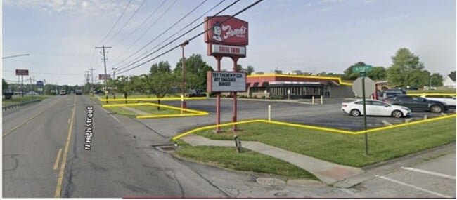
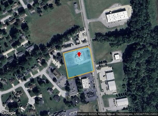
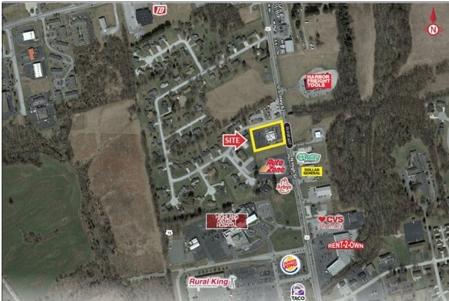
1285 N High St, Hillsboro, OH 45133
This Property Is For Sale
NEARBY LISTINGS FOR SALE OR LEASE
Property Detail
1285 N High St
Restaurantdrivein
2.41 ACRES
X
Highland
39071C0255E
Ohio
2024
2.41 AC
2024
Ohio South Area
954800
Other Market Areas
5,574 SF
25-08-001-007.00
DEMOGRAPHICS near 1285 N High St
1 Mile
3 Mile
5 Mile
2024 Total Population
1,933
8,727
11,616
2029 Population
1,961
8,854
11,749
Pop Growth 2024-2029
+ 1.45%
+ 1.46%
+ 1.14%
Average Age
43
42
42
2024 Total Households
875
3,725
4,794
HH Growth 2024-2029
+ 1.49%
+ 1.37%
+ 1.11%
Median Household Inc
$39,959
$44,720
$48,433
Avg Household Size
2.10
2.20
2.30
2024 Avg HH Vehicles
2.00
2.00
2.00
Median Home Value
$139,072
$148,002
$156,208
Median Year Built
1980
1973
1975
Nearby Places
Map Layers
Map Styles
 Street
 Aerial
- Restaurants
- Banks
- Shops
- Fitness
- Groceries
Nearby Properties
Address
Land Use
TOTAL SIZE
Lot Size
Zoning
Address
Land Use
TOTAL SIZE
Lot Size
Zoning
99,182 SF
5 AC
Address
Land Use
TOTAL SIZE
Lot Size
Zoning
203,044 SF
80.77 AC
Address
Land Use
TOTAL SIZE
Lot Size
Zoning
51,482 SF
58.60 AC
Address
Land Use
TOTAL SIZE
Lot Size
Zoning
70,874 SF
14.63 AC
Address
Land Use
TOTAL SIZE
Lot Size
Zoning
179,189 SF
21.61 AC
Address
Land Use
TOTAL SIZE
Lot Size
Zoning
43,850 SF
3.53 AC
Address
Land Use
TOTAL SIZE
Lot Size
Zoning
109,242 SF
17.83 AC
Address
Land Use
TOTAL SIZE
Lot Size
Zoning
41,144 SF
8.54 AC
Address
Land Use
TOTAL SIZE
Lot Size
Zoning
25,036 SF
4.61 AC
Address
Land Use
TOTAL SIZE
Lot Size
Zoning
143,518 SF
17.57 AC
Address
Land Use
TOTAL SIZE
Lot Size
Zoning
2.02 AC
Address
Land Use
TOTAL SIZE
Lot Size
Zoning
31,332 SF
19.49 AC
Address
Land Use
TOTAL SIZE
Lot Size
Zoning
Address
Land Use
TOTAL SIZE
Lot Size
Zoning
66,362 SF
11.42 AC
Address
Land Use
TOTAL SIZE
Lot Size
Zoning
4,412 SF
5 AC
Address
Land Use
TOTAL SIZE
Lot Size
Zoning
68,946 SF
15.01 AC
Address
Land Use
TOTAL SIZE
Lot Size
Zoning
68.30 AC
Address
Land Use
TOTAL SIZE
Lot Size
Zoning
9,450 SF
9.31 AC
Address
Land Use
TOTAL SIZE
Lot Size
Zoning
14,560 SF
3 AC
Address
Land Use
TOTAL SIZE
Lot Size
Zoning
23,578 SF
0.20 AC
Address
Land Use
TOTAL SIZE
Lot Size
Zoning
26,956 SF
3.18 AC
Address
Land Use
TOTAL SIZE
Lot Size
Zoning
10,956 SF
3.69 AC
Address
Land Use
TOTAL SIZE
Lot Size
Zoning
Address
Land Use
TOTAL SIZE
Lot Size
Zoning
14,613 SF
1.55 AC
Address
Land Use
TOTAL SIZE
Lot Size
Zoning
25,373 SF
0.98 AC
Address
Land Use
TOTAL SIZE
Lot Size
Zoning
24,341 SF
11 AC
Address
Land Use
TOTAL SIZE
Lot Size
Zoning
46,778 SF
3.45 AC
Address
Land Use
TOTAL SIZE
Lot Size
Zoning
24,304 SF
1.45 AC
Address
Land Use
TOTAL SIZE
Lot Size
Zoning
27,808 SF
5.61 AC
Address
Land Use
TOTAL SIZE
Lot Size
Zoning
12,324 SF
10.03 AC
The World's #1 Commercial Real Estate Marketplace
Connect with us
© 2025 CoStar Group
The information above has been obtained from sources believed reliable. While we do not doubt its accuracy we have not verified it and make no guarantee, warranty or representation about it. It is your responsibility to independently confirm its accuracy and completeness. Any projections, opinions, assumptions, or estimates used are for example only and do not represent the current or future performance of the property. The value of this transaction to you depends on tax and other factors which should be evaluated by your tax, financial, and legal advisors. You and your advisors should conduct a careful, independent investigation of the property to determine to your satisfaction the suitability of the property for your needs.