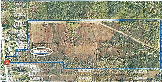
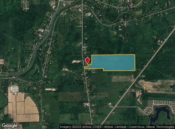
Property Record
1285 New Rd, Buffalo, NY 14228
NEARBY LISTINGS FOR SALE OR LEASE
Property Detail
1285 New Rd
Buffalo-Cheektowaga-Niagara Falls, NY
Holland Land Companys Survey
142289-016-020-0001-007-000
Erie
Agriculturalland
New York
X
7.000
36029C0079H
101.30 AC
2025
North
2024
Buffalo/Niagara Falls
009009
DEMOGRAPHICS near 1285 New Rd
1 Mile
3 Mile
5 Mile
2024 Total Population
1,234
15,173
62,081
2029 Population
1,228
15,050
61,756
Pop Growth 2024-2029
(0.49%)
(0.81%)
(0.52%)
Average Age
43
43
42
2024 Total Households
543
6,146
24,289
HH Growth 2024-2029
(0.74%)
(0.98%)
(0.63%)
Median Household Inc
$95,993
$99,312
$100,476
Avg Household Size
2.20
2.40
2.50
2024 Avg HH Vehicles
2.00
2.00
2.00
Median Home Value
$302,174
$279,147
$311,237
Median Year Built
1993
1987
1986
Nearby Places
- Restaurants
- Banks
- Shops
- Fitness
- Groceries
PUBLIC TRANSPORTATION
AIRPORT
Buffalo Niagara International
DRIVE
WALK
Distance
Buffalo Niagara International
20 min
11.2 mi
Niagara Falls International
DRIVE
WALK
Distance
Niagara Falls International
26 min
15.2 mi
Freight Ports
Albany, NY Port
DRIVE
WALK
Distance
Albany, NY Port
340 min
287.4 mi
Nearby Properties
Address
Land Use
TOTAL SIZE
Lot Size
Zoning
Address
Land Use
TOTAL SIZE
Lot Size
Zoning
5,364 SF
56.45 AC
Address
Land Use
TOTAL SIZE
Lot Size
Zoning
7,080 SF
21.40 AC
MFR-5
Address
Land Use
TOTAL SIZE
Lot Size
Zoning
4,436 SF
18.51 AC
Address
Land Use
TOTAL SIZE
Lot Size
Zoning
253,920 SF
22.83 AC
RD
Address
Land Use
TOTAL SIZE
Lot Size
Zoning
154,296 SF
7.90 AC
RD
Address
Land Use
TOTAL SIZE
Lot Size
Zoning
12,132 SF
12.30 AC
Address
Land Use
TOTAL SIZE
Lot Size
Zoning
87,718 SF
1.26 AC
RD
Address
Land Use
TOTAL SIZE
Lot Size
Zoning
9,338 SF
6.20 AC
Address
Land Use
TOTAL SIZE
Lot Size
Zoning
106,676 SF
8.90 AC
RD
Address
Land Use
TOTAL SIZE
Lot Size
Zoning
131,200 SF
16.90 AC
Address
Land Use
TOTAL SIZE
Lot Size
Zoning
131,128 SF
15.48 AC
RD
Address
Land Use
TOTAL SIZE
Lot Size
Zoning
92,368 SF
0.75 AC
RD
Address
Land Use
TOTAL SIZE
Lot Size
Zoning
86,640 SF
10.30 AC
RD
Address
Land Use
TOTAL SIZE
Lot Size
Zoning
91,035 SF
20.40 AC
Address
Land Use
TOTAL SIZE
Lot Size
Zoning
44,085 SF
7.34 AC
RD
Address
Land Use
TOTAL SIZE
Lot Size
Zoning
33,236 SF
3.44 AC
RD
Address
Land Use
TOTAL SIZE
Lot Size
Zoning
101,742 SF
11.20 AC
SA
Address
Land Use
TOTAL SIZE
Lot Size
Zoning
37,183 SF
62.32 AC
RC
Address
Land Use
TOTAL SIZE
Lot Size
Zoning
8,453 SF
2.46 AC
MFR-4A
Address
Land Use
TOTAL SIZE
Lot Size
Zoning
51,125 SF
12.20 AC
Address
Land Use
TOTAL SIZE
Lot Size
Zoning
11,858 SF
5.30 AC
Address
Land Use
TOTAL SIZE
Lot Size
Zoning
15,969 SF
2.86 AC
Address
Land Use
TOTAL SIZE
Lot Size
Zoning
40,516 SF
4.85 AC
Address
Land Use
TOTAL SIZE
Lot Size
Zoning
6,072 SF
6.46 AC
TND
Address
Land Use
TOTAL SIZE
Lot Size
Zoning
30,208 SF
9.20 AC
RD
Address
Land Use
TOTAL SIZE
Lot Size
Zoning
16.08 AC
RD
Address
Land Use
TOTAL SIZE
Lot Size
Zoning
26,080 SF
16.71 AC
RD
Address
Land Use
TOTAL SIZE
Lot Size
Zoning
21,216 SF
3.90 AC
Address
Land Use
TOTAL SIZE
Lot Size
Zoning
5,000 SF
2.60 AC
Address
Land Use
TOTAL SIZE
Lot Size
Zoning
43,739 SF
2.62 AC
RD
The World's #1 Commercial Real Estate Marketplace
Connect with us
© 2025 CoStar Group
The information above has been obtained from sources believed reliable. While we do not doubt its accuracy we have not verified it and make no guarantee, warranty or representation about it. It is your responsibility to independently confirm its accuracy and completeness. Any projections, opinions, assumptions, or estimates used are for example only and do not represent the current or future performance of the property. The value of this transaction to you depends on tax and other factors which should be evaluated by your tax, financial, and legal advisors. You and your advisors should conduct a careful, independent investigation of the property to determine to your satisfaction the suitability of the property for your needs.