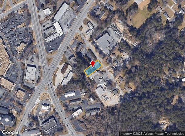
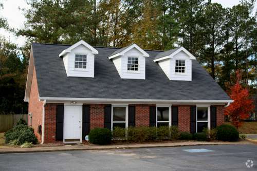
Property Record
1285 Turner Rd Sw, Lilburn, GA 30047

NEARBY LISTINGS FOR SALE OR LEASE
Property Detail
1285 Turner Rd Sw
Atlanta-Sandy Springs-Roswell, GA
Turner Rd
6-079-198
TURNER RD
Officebuilding
Gwinnett
X
Georgia
13089C0084K
79
2025
0.32 AC
2025
Lawrenceville/Lilburn
050430
Atlanta
1,296 SF
DEMOGRAPHICS near 1285 Turner Rd Sw
1 mile
3 mile
5 mile
2024 Total Population
6,601
45,848
183,561
2029 Population
6,848
47,417
188,034
Pop Growth 2024-2029
+ 3.74%
+ 3.42%
+ 2.44%
Average Age
41
41
38
2024 Total Households
2,204
15,742
62,557
HH Growth 2024-2029
+ 3.77%
+ 3.34%
+ 2.30%
Median Household Inc
$101,289
$90,213
$69,271
Avg Household Size
3.00
2.90
2.90
2024 Avg HH Vehicles
2.00
2.00
2.00
Median Home Value
$356,407
$324,745
$279,749
Median Year Built
1980
1981
1984
Nearby Places
Map Layers
Map Styles
 Street
 Aerial
Transit
 Traffic
 Biking
Places
Listings with unknown addresses are not visible on the map
- Restaurants
- Banks
- Shops
- Fitness
- Groceries
PUBLIC TRANSPORTATION
AIRPORT
Hartsfield - Jackson Atlanta International
Drive
Walk
Distance
Hartsfield - Jackson Atlanta International
41 min
26.9 mi
Nearby Properties
Address
Land Use
TOTAL SIZE
Lot Size
Zoning
Address
Land Use
TOTAL SIZE
Lot Size
Zoning
Address
Land Use
TOTAL SIZE
Lot Size
Zoning
2,682,168 SF
80.24 AC
M1
Address
Land Use
TOTAL SIZE
Lot Size
Zoning
301,646 SF
23.90 AC
RM13
Address
Land Use
TOTAL SIZE
Lot Size
Zoning
232,617 SF
19.61 AC
RM
Address
Land Use
TOTAL SIZE
Lot Size
Zoning
307,313 SF
15.60 AC
RM24
Address
Land Use
TOTAL SIZE
Lot Size
Zoning
388,696 SF
13.89 AC
RM100
Address
Land Use
TOTAL SIZE
Lot Size
Zoning
339,612 SF
38.64 AC
C2
Address
Land Use
TOTAL SIZE
Lot Size
Zoning
526,306 SF
77.45 AC
R100
Address
Land Use
TOTAL SIZE
Lot Size
Zoning
335,605 SF
20.22 AC
RM100
Address
Land Use
TOTAL SIZE
Lot Size
Zoning
292,996 SF
15.84 AC
RM100
Address
Land Use
TOTAL SIZE
Lot Size
Zoning
331,031 SF
27.34 AC
RM100
Address
Land Use
TOTAL SIZE
Lot Size
Zoning
180,940 SF
11.78 AC
M1
Address
Land Use
TOTAL SIZE
Lot Size
Zoning
179,784 SF
6.57 AC
C2
Address
Land Use
TOTAL SIZE
Lot Size
Zoning
208,590 SF
26.01 AC
C2
Address
Land Use
TOTAL SIZE
Lot Size
Zoning
111,729 SF
6.67 AC
C2
Address
Land Use
TOTAL SIZE
Lot Size
Zoning
80,014 SF
9.73 AC
R100
Address
Land Use
TOTAL SIZE
Lot Size
Zoning
33,876 SF
22.75 AC
M
Address
Land Use
TOTAL SIZE
Lot Size
Zoning
106,114 SF
16.59 AC
C2
Address
Land Use
TOTAL SIZE
Lot Size
Zoning
89,686 SF
18.29 AC
C2
Address
Land Use
TOTAL SIZE
Lot Size
Zoning
110,588 SF
8.89 AC
C2
Address
Land Use
TOTAL SIZE
Lot Size
Zoning
135,406 SF
14.10 AC
C2
Address
Land Use
TOTAL SIZE
Lot Size
Zoning
123,980 SF
11.50 AC
M1
Address
Land Use
TOTAL SIZE
Lot Size
Zoning
88,892 SF
7.50 AC
M1
Address
Land Use
TOTAL SIZE
Lot Size
Zoning
80,310 SF
4.92 AC
C2
Address
Land Use
TOTAL SIZE
Lot Size
Zoning
52,262 SF
6.02 AC
C3
Address
Land Use
TOTAL SIZE
Lot Size
Zoning
87,415 SF
8.14 AC
M
Address
Land Use
TOTAL SIZE
Lot Size
Zoning
98,336 SF
6.98 AC
C2
Address
Land Use
TOTAL SIZE
Lot Size
Zoning
140,226 SF
17.12 AC
C2
Address
Land Use
TOTAL SIZE
Lot Size
Zoning
78,382 SF
14.53 AC
RM100
Address
Land Use
TOTAL SIZE
Lot Size
Zoning
63,136 SF
4.65 AC
M1
The World's #1 Commercial Real Estate Marketplace
Connect with us
© 2026 CoStar Group
The information above has been obtained from sources believed reliable. While we do not doubt its accuracy we have not verified it and make no guarantee, warranty or representation about it. It is your responsibility to independently confirm its accuracy and completeness. Any projections, opinions, assumptions, or estimates used are for example only and do not represent the current or future performance of the property. The value of this transaction to you depends on tax and other factors which should be evaluated by your tax, financial, and legal advisors. You and your advisors should conduct a careful, independent investigation of the property to determine to your satisfaction the suitability of the property for your needs.